Fews Lower
| Fews Lower Na Feá Íochtaracha[1](Irish) | |
|---|---|
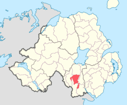 Location of Fews Lower, County Armagh, Northern Ireland. | |
| Sovereign state | United Kingdom |
| Country | Northern Ireland |
| County | Armagh |
Fews Lower (from Irish: na Feá/Feadha, meaning "the woods")[2][3][4] is a barony in County Armagh, Northern Ireland.[5] Its lies in the center of the county, with an enclave lying just to the south-east. The main portion is bordered by four other baronies: Armagh to the west; Oneilland West to the north; Orior Lower to the east; and Fews Upper to the south. Fews Upper and Orior Lower also border the enclave to its north and west, with Orior Upper to its south-west.[5] The Fews Mountains run through both Fews Lower and Upper, the highest peak of which in Fews Lower is, Deadman's Hill, which stands at 1,178 ft.[6]
List of settlements
Below is a list of settlements in Fews Lower:[1]
Towns
Villages and population centres
- Cladymore
- Glenanne
- Hamiltonsbawn
- Loughgilly (also part in the baronies of Orior Lower and Upper)
- Mowhan
List of civil parishes
Below is a list of civil parishes in Fews Lower:[7][8]
- Kilclooney (split with barony Orior Lower)
- Kildarton (split with Oneilland West)
- Lisnadill (split with the baronies of Armagh and Fews Upper)
- Loughgilly (split with barony of Orior Lower and Orior Upper, it also contains the enclave)
- Mullaghbrack (split with barony of Oneilland West)
References
- 1 2 "Fews Lower". Placenames Database of Ireland. Department of Community, Rural and Gaeltacht Affairs. Retrieved 8 June 2011.
- ↑ Placenames Database of Ireland
- ↑ Anthony David Mihttps://books.google.com/books?id=ngc0osGk8FsC&pg=PA139&lpg=PA139&dq=na+Feadha&source=bl&ots=MKE-TElls. "A Dictionary of British Place-names". Oxford University Press. Retrieved 24 July 2012.
- ↑ A Dictionary of Celtic Mythology. Oxford Reference.
- 1 2 PRONI Baronies of Northern Ireland
- ↑ "Atlas and Cyclopedia of Ireland (1900)". Library Ireland. Retrieved 8 June 2011.
- ↑ PRONI Civil Parishes of County Armagh
- ↑ Baronies and civil parishes of County Armagh
Geography of County Armagh | ||
|---|---|---|
| Cities and towns |  | |
| Villages and townlands |
| |
| Landforms | ||
| Baronies | ||
| ||
This article is issued from Wikipedia - version of the 11/7/2016. The text is available under the Creative Commons Attribution/Share Alike but additional terms may apply for the media files.