Fat Tong Chau
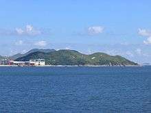

Fat Tong Chau (佛堂洲, Junk Island) is a former island of Hong Kong. It is now part of Tseung Kwan O (also called Junk Bay) and Clear Water Bay Peninsula, Sai Kung as a result of land reclamation. It is located in the southeastern part of Junk Bay.
Location
Fat Tong Chau is located south of the Tseung Kwan O Industrial Estate and directly west of TVB City. The South East New Territories Landfill (SENT) is located south of Fat Tong Chau. Before land reclamation, Fat Tong Chau formed the northern boundary of Tathong Channel.
Chinese Customs Station
The site of Chinese Customs Station, a declared monument of Hong Kong, is located in the northwestern part of Fat Tong Chau. Archaeological finds from the site are being exhibited at Hong Kong Museum of History,[1] including the "Foster benevolence over Indo-China; tributes and taxes circulate from afar" stone tablet.[2]
References
External links
- Map of Tseung Kwan O Industrial Estate, showing Fat Tong Chau and the site of Chinese Customs Station
| Wikimedia Commons has media related to Fat Tong Chau. |
Coordinates: 22°17′N 114°16′E / 22.283°N 114.267°E