Farmington, Washington County, Wisconsin
| Farmington, Wisconsin | |
|---|---|
| Town | |
|
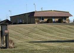
Town hall along WIS 28 | |
 Location of Farmington, Washington County, Wisconsin | |
| Coordinates: 43°30′20″N 88°5′45″W / 43.50556°N 88.09583°WCoordinates: 43°30′20″N 88°5′45″W / 43.50556°N 88.09583°W | |
| Country | United States |
| State | Wisconsin |
| County | Washington |
| Area | |
| • Total | 36.7 sq mi (95.0 km2) |
| • Land | 36.4 sq mi (94.2 km2) |
| • Water | 0.3 sq mi (0.8 km2) |
| Elevation[1] | 896 ft (273 m) |
| Population (2000) | |
| • Total | 3,239 |
| • Density | 89.0/sq mi (34.4/km2) |
| Time zone | Central (CST) (UTC-6) |
| • Summer (DST) | CDT (UTC-5) |
| Area code(s) | 262 |
| FIPS code | 55-25375[2] |
| GNIS feature ID | 1583193[1] |
| Website |
town |
Farmington is a town in Washington County, Wisconsin, United States. The population was 3,239 at the 2000 census. The unincorporated communities of Boltonville, Cheeseville, Fillmore, and Orchard Grove are located in the town. The unincorporated community of Saint Michaels is also located partially in the town.
Parks
Farmington is home to Lizard Mound County Park, a collection of earthen mounds in animal, bird, and geometric shapes built around 10,000 years ago by an unknown tribe of mound-building Native Americans.
Geography
Farmington is located in the Kettle Moraine region of Wisconsin, home to unique geographical features formed by the many glaciers that shaped the area. Kames, eskers, drumlins, kettle lakes, rivers, and streams were the result.
According to the United States Census Bureau, the town has a total area of 36.7 square miles (95.0 km²), of which, 36.4 square miles (94.2 km²) of it is land and 0.3 square miles (0.8 km²) of it (0.82%) is water.
Demographics
As of the census[2] of 2000, there were 3,239 people, 1,116 households, and 945 families residing in the town. The population density was 89.0 people per square mile (34.4/km²). There were 1,183 housing units at an average density of 32.5 per square mile (12.6/km²). The racial makeup of the town was 99.17% White, 0.09% African American, 0.22% Native American, 0.09% Asian, 0.03% Pacific Islander, and 0.40% from two or more races. Hispanic or Latino of any race were 0.90% of the population.
There were 1,116 households out of which 38.6% had children under the age of 18 living with them, 77.8% were married couples living together, 3.9% had a female householder with no husband present, and 15.3% were non-families. 11.4% of all households were made up of individuals and 3.9% had someone living alone who was 65 years of age or older. The average household size was 2.90 and the average family size was 3.14.
In the town the population was spread out with 27.4% under the age of 18, 6.4% from 18 to 24, 31.9% from 25 to 44, 25.8% from 45 to 64, and 8.5% who were 65 years of age or older. The median age was 38 years. For every 100 females there were 104.5 males. For every 100 females age 18 and over, there were 106.6 males.
The median income for a household in the town was $61,667, and the median income for a family was $63,508. Males had a median income of $41,953 versus $25,595 for females. The per capita income for the town was $23,082. About 1.9% of families and 3.5% of the population were below the poverty line, including 7.3% of those under age 18 and 1.2% of those age 65 or over.
References
- 1 2 "US Board on Geographic Names". United States Geological Survey. 2007-10-25. Retrieved 2008-01-31.
- 1 2 "American FactFinder". United States Census Bureau. Retrieved 2008-01-31.
External links
Municipalities and communities of Washington County, Wisconsin, United States | ||
|---|---|---|
| Cities |  | |
| Villages | ||
| Towns | ||
| CDP | ||
| Unincorporated communities |
| |
| Footnotes | ‡This populated place also has portions in an adjacent county or counties | |