False Cape State Park
| False Cape State Park | |
|---|---|
|
IUCN category V (protected landscape/seascape) | |
|
False Cape State Park is bounded on the west by Back Bay of the Currituck Sound | |
  Location of False Cape State Park | |
| Location | Virginia, United States |
| Nearest city | Virginia Beach, VA |
| Coordinates | 36°35′16″N 75°53′3″W / 36.58778°N 75.88417°WCoordinates: 36°35′16″N 75°53′3″W / 36.58778°N 75.88417°W |
| Area | 4,321 acres (17.49 km2) |
| Governing body | Virginia Department of Conservation and Recreation |
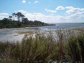
False Cape State Park is a Virginia state park located on the Currituck Banks Peninsula, a mile-wide barrier spit between the Back Bay of the Currituck Sound and the Atlantic Ocean and within the city of Virginia Beach.
Adjoining the state border with North Carolina and lying just north of Mackay Island National Wildlife Refuge, False Cape park features primitive camping, hiking and biking trails, a visitors' center and extensive environmental educational programs.
The Park can be accessed from the north through Back Bay National Wildlife Refuge on foot, bicycle, or a seasonally available tram — or from the south on foot or bicycle — or from any of its shorelines by boat. Limited vehicular (i.e., car/truck) access remains for grand-fathered permit holders.
History
False Cape was so named because from the ocean it could be easily mistaken for Cape Henry, which lies about 20 miles (30 km) to the north at the mouth of the Chesapeake Bay.[1] This false impression lured ships and boats looking for Cape Henry into the shallow waters, where they could easily run aground.
The community of Wash Woods, now abandoned, was developed by survivors of such a shipwreck in the 16th or early 17th century.[2] The village’s church and other structures were built using cypress wood that washed ashore from a wreck. In the early 20th century, False Cape was a haven for a number of hunt clubs taking advantage of the area's abundant waterfowl. The park's Wash Woods Environmental Education Center is a converted hunt clubhouse.[3]
Undeveloped portions of the park were rededicated as the False Cape Natural Area Preserve in 2002.


At the south end of False Cape is a monument with "Va." on one side and "N Ca" on the other. Although it reads "A.D. 1728" on the top, it was more likely erected in 1887 when the boundary was surveyed again, since the original marker was a simple cedar post. "A.D. 1728" refers to the year the current boundary was first surveyed.[4]
In 2004, The Virginian-Pilot reported poor conditions at a trash dump area in the park which were subsequently resolved by a cleanup project park employees, volunteers and private firms.
See also
- Wash Woods
- Virginia Beach, Virginia
- Back Bay National Wildlife Refuge
- Former counties, cities, and towns of Virginia
References
- ↑ "False Cape State Park". StateParks.com. statepark.com. Retrieved 13 April 2016.
- ↑ "Wash Woods - Yahoo! Voices". voices.yahoo.com. Retrieved 2012-02-03.
- ↑ "Orbitz Travel: Vacations, Cheap Flights, Airline Tickets & Airfares". Retrieved 26 May 2016.
- ↑ "Virginia-North Carolina Boundary". Retrieved 26 May 2016.
External links
| Wikimedia Commons has media related to False Cape State Park. |
- False Cape State Park
- False Cape State Park in World Database on Protected Areas
- Waterland Farm website with photos of remains of Wash Woods
- Museumsusa.org, False Cape State Park webpage
- VirginiaBeach.com
| Topics |  | |
|---|---|---|
| Parks | ||
| Military | ||
| Attractions |
| |
| Neighborhoods | ||