Falcon Dam
| Falcon Dam | |
|---|---|
 Falcon Dam | |
 Location of Falcon Dam in Mexico | |
| Location | Starr County, Texas, USA / Guerrero Municipality, Tamaulipas, Mexico |
| Coordinates | 26°33′32″N 99°09′53″W / 26.55889°N 99.16472°WCoordinates: 26°33′32″N 99°09′53″W / 26.55889°N 99.16472°W |
| Construction began | 1950 |
| Opening date | 1954 |
| Construction cost | $35 million (U.S. Share) |
| Dam and spillways | |
| Impounds | Rio Grande |
| Height | 150 ft (46 m) |
| Length | 26,294 ft (8,014 m) |
| Width (base) | 35 ft (11 m) (Crest) |
| Reservoir | |
| Creates | Falcon International Reservoir |
| Total capacity | 2,645,646 acre·ft (3.263356×10⁹ m3) |
| Surface area | 87,400 acres (354 km2) |
| Power station | |
| Turbines | 6 x 10.5 MW Francis |
| Installed capacity | 63 MW[1] |
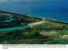
Falcon Dam is an earthen embankment dam on the Rio Grande between Starr County in the U.S. state of Texas and the city of Nueva Ciudad Guerrero in the Mexican state of Tamaulipas. The dam was built for water conservation, irrigation, hydroelectric power generation, flood control, and recreational purposes and as an international border crossing between Zapata and Starr Counties and Tamaulipas. Construction on the dam began in December 1950 and ended in April 1954 but it was dedicated by presidents Adolfo Ruiz Cortines and Dwight D. Eisenhower in October 1953.[2]
Construction
The Falcon Dam was authorized by the Treaty for the Utilization of Waters of the Colorado and Tijuana Rivers and of the Rio Grande or Water Treaty of 1944 between Mexico and the United States. Construction on the dam began on 15 December 1950 and the reservoir began to fill on 25 August 1953. The dam was dedicated on 19 October 1953 and work was officially complete on 8 April 1954. By October 1954, the dam's hydroelectric power station began to produce electricity.[1]
Characteristics

The Falcon Dam is a 150 ft (46 m) high and 26,294 ft (8,014 m) long earthen embankment dam. The dam is made of 12,600,000 cu yd (9,633,391 m3) of earth-fill, 282,000 cu yd (215,604 m3) of concrete and 10,300 short tons (9,344 t) of reinforced steel. The center of the dam is over-topped with a 1,300 ft (396 m) long spillway with widths ranging from 350 ft (107 m) at the top and 600 ft (183 m) at the bottom. The spillway is controlled by six 50 ft × 50 ft (15 m × 15 m) fixed wheel gates and can release up to 456,000 cu ft/s (12,912 m3/s) downstream.[1]
The Falcon Dam supplies water to two different hydroelectric power plants, one on the Mexican side and another on the U.S. side. Each power plant contains 3 x 10.5 MW Francis turbine generators for a combined total of 63 MW. Each power plant also receives water from the reservoir via 4 x 13 ft (4 m) diameter penstocks. The two extra penstocks are for an additional generator if needed.[1]
The Falcon Dam created the Falcon International Reservoir that has a volume of 2,645,646 acre·ft (3.263356×10⁹ m3) and a surface area of 87,400 acres (354 km2).[1]
2010 plot to destroy the dam
In June 2010, U.S. authorities revealed that the Los Zetas drug cartel had planned to destroy the Falcon Dam in order to terrorize the rival Gulf Cartel which smuggles drugs in the area. Small amounts of dynamite discovered near the dam and a copy of a warning helped alert authorities. A larger U.S. and Mexican security presence in the area may have thwarted the attack that Los Zetas had reportedly warned civilians about on the Mexican-side of the border.[3]
References
- 1 2 3 4 5 "Falcon Dam and Power Station Brochure" (PDF).
- ↑ International Boundary and Water Commission; Falcon Dam
- ↑ Schiller, Dane; James Pinkerton (2010-06-02). "Agents feared Mexican drug cartel attack on border dam". Houston Chronicle.
External links
- Falcon Dam & Power Plant - U.S. State Dept Website
- "Falcon Dam". Geographic Names Information System. United States Geological Survey.