Fairholme Range
| Fairholme Range | |
|---|---|
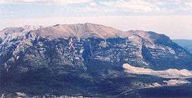 Grotto Mountain in 2005 | |
| Highest point | |
| Peak | Mount Girouard |
| Elevation | 2,995 m (9,826 ft) |
| Coordinates | 51°14′15″N 115°24′05″W / 51.23750°N 115.40139°W |
| Geography | |
 | |
| Country | Canada |
| Province | Alberta |
| Range coordinates | 51°10′N 115°18′W / 51.17°N 115.3°WCoordinates: 51°10′N 115°18′W / 51.17°N 115.3°W |
| Parent range | Canadian Rockies |
The Fairholme Range is a mountain range east of the Bow River valley in the Canadian Rockies. The range is bounded by the Trans-Canada Highway on the west side while the northern section of the range extends into Banff National Park to the southern shores of Lake Minnewanka. John Palliser named the range in 1859 after his sister Grace Fairholme, who had married William Fairholme.[1]
Peaks of this range include:
| Mountain/Peak | metres | feet |
|---|---|---|
| Mount Girouard | 2,995 | 9,827 |
| Mount Inglismaldie | 2,964 | 9,725 |
| Mount Peechee | 2,935 | 9,630 |
| Mount Charles Stewart | 2,809 | 9,216 |
| Grotto Mountain | 2,706 | 8,878 |
| Mount Lady Macdonald | 2,606 | 8,550 |
| Princess Margaret Mountain | 2,515 | 8,252 |
| Squaw's Tit | 2,514 | 8,250 |
In the spring and summer of 2003, Parks Canada performed a prescribed burn in selected areas of the range in order to reduce fire hazard, manage pine beetle population and increase sheep habitat. In total, 5300 hectares of land were affected.[2]
References
- ↑ "Fairholme Range". PeakFinder. Retrieved 2004-06-15.
- ↑ "2003 Prescribed burn in the Fairholme Range". Parks Canada. Archived from the original on 2011-07-06. Retrieved 2005-10-16.
This article is issued from Wikipedia - version of the 9/3/2016. The text is available under the Creative Commons Attribution/Share Alike but additional terms may apply for the media files.