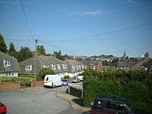
Exwick

Coordinates: 50°44′16″N 3°32′50″W / 50.73786°N 3.54732°W
Exwick is a suburb of Exeter, England, in the north-west of the City. Its name is derived from the River Exe, which forms its eastern boundary. It is also an Ecclesiastical parish and an electoral ward.
Population
In 2006 the population of Exwick Ward was approximately 9400 . Over a third of the population are aged 0–25 with less than 10% aged over 65. The percentage of lone parent households with dependent children is 8.2% which is above the city, county and national average. The percentage of lone pensioner households is 7.7% which is below the city, county and national average.
Housing
The majority of properties in Exwick are owner occupied. Of the 3708 properties in Exwick ward, 68.7% are owner occupied, 5.2% Local Authority rented, 16.6% Housing Association rented and 7.3% privately rented. House prices in the ward are below the county and national average.
Early history
When the Domesday Book was compiled for William the Conqueror in 1086 Exwick was called 'Essoic' and was reported as being held by Eureuuacus. It contained 8 ploughs, 9 villeins, 5 serfs, 40 sheep, a mill, 3 acres (12,000 m2) of meadow, 3 acres (12,000 m2) of coppice and 50 acres (200,000 m2) of pasture.
One of William the Conqueror's knights was Baldwin FitzGilbert (Baldwin de Brionne), a nephew by marriage. He was to become a very powerful man in the West Country, was made Governor of Exeter, Sheriff of Devon and built Okehampton Castle and Exeter's Rougemont Castle. Duke William granted Baldwin manors and these included Exwick.
On Baldwin's death his son William FitzBaldwin inherited the title and family land and he made a gift of the manors of Cowick and Exwick to the French Benedictine abbey of Bec-Hellouin. A cell of the abbey was set up in Cowick with a Priory Church of Saint Andrew. Cowick Priory managed the tithes and income from Exwick and other nearby manors.
During the reign of Henry V, in the 15th century, when England was at war with France, Cowick Priory was suppressed and the monks moved back to Normandy. It was refounded by his successor Henry VI in 1440 but was granted to Eton College in 1451 or 1452 and then given to Tavistock Abbey in 1463 or 1464 by Edward IV.[1] In 1467 it was restored to Eton, but Tavistock maintained that the priory had held conventual status and ought to be served by 'religious men yf eny coude be founde' and in 1478 secured confirmation of the king's earlier grant.
With the dissolution of the monasteries by Henry VIII in 1537/38, Tavistock Abbey was surrendered to the King and the monastery estate (which included the manors of Cowick and Exwick) was granted to John Russell, 1st Earl of Bedford in 1539.
Exwick Parish

Exwick Parish is an Ecclesiastical Parish, which was created from the parish of St Thomas the Apostle in 1872, and is part of the Diocese of Exeter. The parish church is called St Andrew's Church, which was built during 1841-1842, to a design by the architect John Hayward and consecrated on September 26, 1842. Money to build the church was raised by subscription, aided with a grant of £500 from the Church Building Society. James Wentworth Buller (Member of Parliament for Crediton and Lord of the Manor) donated £100 and the site. The Ecclesiologist in July 1842, described it as the “best specimen of modern church we have yet seen."[2]
Exwick Ward
Exwick Ward is an electoral ward of England. Its ward code is 18UCFY. (The 18 signifies Devon, UC is Exeter and FY is Exwick). The northern boundary generally follows the boundary of the old parish of St Thomas the Apostle, just north of Exwick Wood and Exwick Barton. The eastern boundary runs down the centre of the River Exe as far as Blackaller Weir, which is the weir underneath the new Millers Crossing bridge near the 'Mill on the Exe' pub. The southern boundary runs across the Flowerpot playing fields and up Isleworth Road to Nadderbrook. The western boundary goes up Nadderbrook, cuts east at Whitestone Cross and then goes north to the western edge of Exwick Wood.
Exeter City Council has three Councillors representing Exwick Ward; At 2012, all of them were from the Labour Party.
Public transport
Public Transport in Exwick is limited to buses, operated by Stagecoach Devon, and taxis. The bus services are the E, F1 and F2.
Railway services are provided at Exeter St Davids station, which is a short walk away from Exwick on the eastern side of the river.
References
- ↑ "Detailed Result: COLWICK PRIORY". Pastscape. Retrieved 2010-04-07.
- ↑ Stanton, Phoebe B. (1997-05-08). The Gothic revival & American church architecture: an episode in taste. ISBN 9780801856228. Retrieved 8 May 2010. quoting The Ecclesiologist, July 1842
- Devon County Council. "Facts and Figures". Retrieved 2007-03-16.