Exminster
Exminster is a village situated on the southern edge of the City of Exeter on the western side of the Exeter ship canal and River Exe in the county of Devon, England. It is around 6 km (3.7 mi) south of the centre of Exeter, and has a population of 3,084 (census 2001), increasing to 3,368 at the 2011 census.[1] Exminster is an ancient village associated with a Saxon minster or religious community, founded here in the 8th century.[2] In the 14th century, it was the seat of the Courtenay family, the Earls of Devon. William Courtenay, who was the Archbishop of Canterbury from 1381 to 1396, was born here.[3] Exminster is a major part of the electoral ward of Kenn Valley. Its population at the above census was 5,906[4] Exminster Marshes, to the east of the village, are a major site for birds, especially migratory ones[5] including the rare cirl bunting.[6]
Landmarks
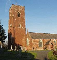
The present parish church of Saint Martin of Tours is a Grade I listed building and was built in the late 14th and 15th centuries in the Perpendicular style. It was heavily restored in 1841 and again in 1852. It has a large three-storied tower with a polygonal stair turret. Inside, the Peamore chapel has a plaster ceiling dated 1633, depicting the Twelve Apostles and the Four Evangelists, scenes of the Nativity, Christ carrying the cross and the Resurrection. There is also a notable monument to Otho Petre of Bowhay who died in 1607.[7] The churchyard contains the war graves of eight British service personnel of World War I - the first and highest ranking being Major General Robert Kekewich[8] - and three of World War II.[9]
The football club of Exminster is Exminster St Martins AFC

On a hill overlooking the Exe estuary at the north-west side of the village is the former Devon County Asylum (a "lunatic asylum") which was designed by Charles Fowler and opened in July 1845. It featured a central administration block with six radiating arms and had a capacity of around 800 beds. The hospital closed in the mid-1980s when it was known as Exminster Hospital.[10] After years of neglect, the surrounding land was built upon for housing and the grade II listed hospital was converted to apartments and town houses; it is now known as Devington Park.[11]

Exminster railway station was opened by George Hennet on behalf of the South Devon Railway in 1852. It closed to passenger traffic on 30 March 1964 and to goods on 4 December 1967, but its distinctive building still stands next to the railway line. The signal box remained standing on the site until September 2006 but has now been removed for preservation to Broadway, Worcestershire.[12]
Economy
Exminster's amenities include a surgery, pharmacy, a village shop, a convenience store, several estate agents, a golf course, a hairdresser, as well as a community facility (The Westbank) which incorporates a gym, an IT suite with web access, and daytime family and toddlers' groups. Exminster also has a primary school; several parks for children including a skate park; and three pubs – The Stowey Arms, The Royal Oak and The Swan's Nest. The Topsham and Exminster Brewery, which produces Ferryman Ale, is located at a former RAF GCI (Ground Controlled Interception) radar station in the midst of the Exminster Marshes RSPB reserve.
The Exeter Canal cycle path leads from Exminster into the centre of Exeter, giving commuters in the village a traffic-free route into the city.[13]
Historic estates
- Peamore, Exminster
- Bowhay, a seat of the Petre family,[14] later the seat of Aaron Baker (1620–1683) the first President of the Madras Presidency (1652-1655).[15]
References
- ↑ "Exminster population 2011". Retrieved 18 February 2015.
- ↑ http://www.devon.gov.uk/historicexminster
- ↑ http://www.british-history.ac.uk/report.aspx?compid=50577
- ↑ "Kenn Valley ward population 2011". Retrieved 18 February 2015.
- ↑ BBC Devon article. Retrieved on 18 May 2007
- ↑ BBC Devon article. Retrieved on 18 May 2007.
- ↑ http://www.britishlistedbuildings.co.uk/en-85452-church-of-st-martin-exminster
- ↑ CWGC Casualty Record.
- ↑ CWGC Cemetery Report, details obtained from casualty record.
- ↑ Index of English and Welsh Lunatic Asylums and Mental Hospitals. Retrieved on 18 May 2007
- ↑ "Transformation at former hospital", Western Morning News, Plymouth., 27 March 2001(Subscription required.)
- ↑ Broadway signal box website. Retrieved on 18 May 2007
- ↑ Local map of cycling route between Exminster and Exeter
- ↑ Hoskins, W.G., A New Survey of England: Devon, London, 1959 (first published 1954), p.395
- ↑ Per inscription on his mural monument in nearby Dunchideock Church
External links
| Wikimedia Commons has media related to Exminster. |
- Exminster's Community Website
- Devington Park - the alternative Website
- Exminster at DMOZ
- Exminster in the Domesday Book
Coordinates: 50°40′39″N 3°29′40″W / 50.677568°N 3.494527°W