Evaro, Montana
| Evaro, Montana | |
|---|---|
| CDP | |
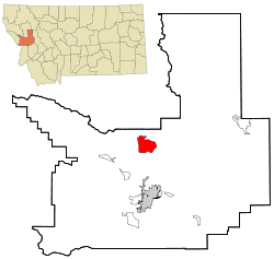 Location of Evaro, Montana | |
| Coordinates: 47°4′36″N 114°3′1″W / 47.07667°N 114.05028°WCoordinates: 47°4′36″N 114°3′1″W / 47.07667°N 114.05028°W | |
| Country | United States |
| State | Montana |
| County | Missoula |
| Area | |
| • Total | 17.0 sq mi (44.1 km2) |
| • Land | 17.0 sq mi (44.1 km2) |
| • Water | 0.0 sq mi (0.0 km2) |
| Elevation | 3,960 ft (1,207 m) |
| Population (2010) | |
| • Total | 322 |
| • Density | 19.3/sq mi (7.5/km2) |
| Time zone | Mountain (MST) (UTC-7) |
| • Summer (DST) | MDT (UTC-6) |
| ZIP code | 59801 |
| Area code(s) | 406 |
| FIPS code | 30-25000 |
| GNIS feature ID | 0783256 |
Evaro is a census-designated place (CDP) in Missoula County, Montana, United States. It is part of the Missoula, Montana Metropolitan Statistical Area. The population was 322 at the 2010 census, a decrease from its population of 329 in 2000.
Geography
Evaro is located at 47°04′36″N 114°03′01″W / 47.076573°N 114.050225°W (47.076573, -114.050225).[1]
According to the United States Census Bureau, the CDP has a total area of 17.0 square miles (44 km2), all of it land.
Evaro Hill, south of Evaro, is known as snɫp̓upƛ̓m or snɫp̓u ("small clearing on the hillop") in Salish.[2]
Demographics
As of the census[3] of 2000, there were 329 people, 110 households, and 84 families residing in the CDP. The population density was 19.3 people per square mile (7.5/km2). There were 117 housing units at an average density of 6.9/sq mi (2.7/km2). The racial makeup of the CDP was 47.72% White, 44.68% Native American, 0.30% Pacific Islander, and 7.29% from two or more races. Hispanic or Latino of any race were 10.03% of the population.
There were 110 households out of which 42.7% had children under the age of 18 living with them, 60.9% were married couples living together, 10.0% had a female householder with no husband present, and 23.6% were non-families. 18.2% of all households were made up of individuals and 7.3% had someone living alone who was 65 years of age or older. The average household size was 2.99 and the average family size was 3.43.
In the CDP the population was spread out with 32.8% under the age of 18, 9.4% from 18 to 24, 28.6% from 25 to 44, 24.6% from 45 to 64, and 4.6% who were 65 years of age or older. The median age was 31 years. For every 100 females there were 103.1 males. For every 100 females age 18 and over, there were 102.8 males.
The median income for a household in the CDP was $36,250, and the median income for a family was $39,583. Males had a median income of $41,458 versus $21,875 for females. The per capita income for the CDP was $15,465. About 4.3% of families and 6.8% of the population were below the poverty line, including none of those under age 18 and 33.3% of those age 65 or over.
References
| Wikimedia Commons has media related to Evaro, Montana. |
- ↑ "US Gazetteer files: 2010, 2000, and 1990". United States Census Bureau. 2011-02-12. Retrieved 2011-04-23.
- ↑ Tachini, Pete (2010). Seliš nyoʻnuntn, Medicine for the Salish language : English to Salish translation dictionary (2nd ed.). Pablo, MT: Salish Kootenai College Press. p. 374. ISBN 9781934594063.
- ↑ "American FactFinder". United States Census Bureau. Archived from the original on September 11, 2013. Retrieved 2008-01-31.
Municipalities and communities of Missoula County, Montana, United States | ||
|---|---|---|
| City | 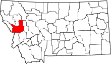 | |
| CDPs | ||
| Unincorporated communities | ||
| Ghost towns | ||
| Indian reservation | ||
| Footnotes | ‡This populated place also has portions in an adjacent county or counties | |