Etwall railway station
| Etwall | |
|---|---|
|
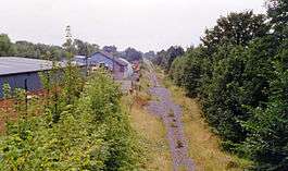
Site of the station (1993) | |
| Location | |
| Place | Etwall |
| Area | South Derbyshire |
| Operations | |
| Original company | Great Northern Railway |
| Post-grouping |
London and North Eastern Railway London Midland Region of British Railways |
| Platforms | 2 |
| History | |
| 1 April 1878[1] | Opened |
| 4 December 1939 | Closed to passengers |
| 4 March 1968[2] | Goods facilities withdrawn |
| Disused railway stations in the United Kingdom | |
|
Closed railway stations in Britain A B C D–F G H–J K–L M–O P–R S T–V W–Z | |
|
| |
Etwall railway station was a former railway station in Etwall, Derbyshire. It was opened by the Great Northern Railway (Great Britain) on its Derbyshire Extension in 1878.
History
From Mickleover the line dropped at about 1 in 110 towards Etwall.
The station was very close to the village, being adjacent to the Uttoxeter road which crossed the line by a steeply sloped bridge. It was provided with substantial brick buildings similar to others on the line; a two-storey station master's house and the usual single storey offices on one platform, with a small timber waiting room on the other.
Regular passenger traffic finished in 1939, although it saw excursions until 1963, and it closed in the following year.
The line from Friargate remained open for some years, being used as a test track by the British Rail Research Division. After public services finished, the stationmaster continued to live in the house.
| Preceding station | Disused railways | Following station | ||
|---|---|---|---|---|
| Mickleover | Great Northern Railway (Derby) Friargate Line |
Egginton Junction | ||
Present day
The goods yard was sold to an agricultural engineering company who later bought the house and demolished it 1987-8.[3] In the early 2000s, a small housing development was constructed on the site; the road leading into the site being called 'Old Station Close'. The footpath constructed on the old trackbed can be reached from this estate.
References
- ↑ Butt, R.V.J. (1995). The Directory of Railway Stations, Patrick Stephens Ltd, Sparkford, ISBN 1-85260-508-1, p. 92.
- ↑ Clinker, C.R. (October 1978). Clinker's Register of Closed Passenger Stations and Goods Depots in England, Scotland and Wales 1830-1977. Bristol: Avon-AngliA Publications & Services. p. 46. ISBN 0-905466-19-5.
- ↑ Higginson, M., (1989) The Friargate Line:Derby and the Great Northern Railway, Derby: Golden Pingle Publishing
Coordinates: 52°52′54″N 1°36′29″W / 52.8817°N 1.6081°W