Etawah
| Etawah इटावा | |
|---|---|
| city | |
 Etawah | |
| Coordinates: 26°46′N 79°02′E / 26.77°N 79.03°ECoordinates: 26°46′N 79°02′E / 26.77°N 79.03°E | |
| Country | India |
| State | Uttar Pradesh |
| District | Etawah |
| Elevation | 197 m (646 ft) |
| Population (2014) | |
| • Total | 257,838 |
| • Density | 684/km2 (1,770/sq mi) |
| Languages | |
| • Official | Hindi |
| Time zone | IST (UTC+5:30) |
| PIN | 206001 |
| Telephone code | 05688 |
| Vehicle registration | UP75 |
| Website |
www |
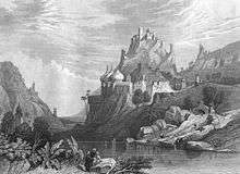
Etawah is a city on the banks of Yamuna River in the state of Uttar Pradesh in India. It is the administrative headquarters of Etawah District. The city was an important center for the Revolt of 1857 (Allan Octavian Hume, the founder of Indian National Congress was district collector then). Also is the place of sangam or confluence between Yamuna and Chambal. It is also the site of the remains of the Great Hedge of India. The noted Hindi writer Gulabrai was a native of Etawah.
Demographics
As per 2011 census, Etawah city had a population of 257,838 - an increase of 22% from 211,460 in 2001 census. (The entire Etawah district had a population of 1,581,810 in 2011.) The literacy rate was 82.89 per cent.[1]
History
Ancient era
This region is believed to have existed even in the Bronze Age.The earliest Aryans who lived here were the Panchalas.They are said to have had close connections with Kurus.
Tradition holds the history of the town started with its foundation by a successor of King Bharat. The region also finds mention in the Mahabharata and Ramayana epics.
The Guptas, Kanvas, Kanishka, Naga kings ruled over this area. In the fourth century A.D., it was part of united India under the Guptas.
During the ninth and tenth centuries, this region was governed by Gurjara Pratihara rulers. The conquest of Kannauj by Nagabhata II handed Pratiharas control over this region. During the reign of Gurjara Pratihara monarch Mihir Bhoj, the region is mentioned as prosperous, safe from thieves and rich in natural resources.[2]
In 1244, Ghiyas ud din Balban attacked the region.[3]
Revolt of 1857
During the First War of Independence in 1857, major disturbances occurred in Etawah and the district was occupied by the freedom fighters from June to December. British rule was not completely restored till the end of 1858.
Modern history and economy
Etawah has experienced modernization and development under British Raj and in the post-independence period.
The district is partly watered by branches of the Ganges canal.
It is traversed by the main line of the Indian railway (northern zone) from Delhi to Howrah (Calcutta).
Cotton, oilseeds, ghee and other agricultural produce are grown and exported. Special breed of goat Jamunapaari and special breed of buffalo Bhadawari are raised and exported.
The region has a 652 MW natural gas-based power generation plant. However it lacks manufacturing industries.
Etawah was known for its handloom products; most of them are converted into powerlooms thanks to the advent of better technology. 'Etawah' is derived from the burner of bricks (where bricks are made); it has thousands of brick centre between its boundaries.
Notable People
- Rahul dwivedi- STAR PLUS
- Piaa Bajpai
- Wahid Khan
- George Adamson
Transport
Rail
| Mainpuri-Etawah Branch Railway Line | |||||||||||||||||||||||||||||||||||||||||||
|---|---|---|---|---|---|---|---|---|---|---|---|---|---|---|---|---|---|---|---|---|---|---|---|---|---|---|---|---|---|---|---|---|---|---|---|---|---|---|---|---|---|---|---|
| |||||||||||||||||||||||||||||||||||||||||||
Etawah railway station lies on Kanpur-Delhi section of Howrah-Delhi main line. Shatabdi Express and many other superfast trains have a scheduled halt in Etawah.
Also CNB Shatabdi halts at etawah.
Now it is connected to Bhind district of Madhya Pradesh by train. The distance between bhind and etawah is 35.6 km.
Road
Etawah is well-connected by roads with the rest of Uttar Pradesh state. National Highway 2 passes through Etawah, connecting it to important cities like Delhi, Agra, Kanpur, Allahabad, Varanasi, Mughalsarai, Dhanbad and Kolkata. There are three big cities namely Gwalior, Agra and Kanpur, are nearby to Etawah with well connected roads.
Within the city, auto-rickshaw and cycle rickshaw are the major form of transport. Bus services run at high frequencies.
Education
Universities
- Faculty of Agricultural Engineering and Technology, Chandra Shekhar Azad University of Agriculture and Technology or Baba Saheb Dr. B.R.A. College of Agriculture Engineering & Technology, Etawah is a faculty of Technology of Kanpur's Chandra Shekhar Azad University of Agriculture and Technology, established during the year 1994-95.
- Uttar Pradesh University of Medical Sciences (formerly U.P. Rural Institute of Medical Sciences and Research) Saifai, Etawah is a medical research public university, established by Government of Uttar Pradesh under Act,15 of 2016. The University is running full-fledged Medical College, Paramedical College, Nursing College, Pharmacy College, Multi Specialty 850 bedded hospital and 150 bedded trauma and burn centre. 500 bedded super specialty hospital is being established in the University by Government of Uttar Pradesh with budget of Rs. 650 crores.[4][5][6]
Schools & Colleges
- Karm Kshetra Post Graduate College or K.K. P.G. College, Etawah is a college offering under-graduate and post-graduate courses in Science, Arts, Commerce faculties. The college is affiliated to Chhatrapati Shahu Ji Maharaj University (formerly Kanpur University).
- District Institute of Education and Training, Etawah is a B.T.C. training college. It offers 2 year B.T.C. which is also known as Diploma in Elementary Education (D.El.Ed.) outside of Uttar Pradesh.
- St. Mary's Inter College, Etawah is an English medium School in Etawah. The school is affiliated to CBSE, New Delhi and NCERT published books are introduced form class VI and onwards.
See also
References
- ↑ "Urban Agglomerations/Cities having population 1 lakh and above" (PDF). Provisional Population Totals, Census of India 2011. Retrieved 2012-07-07.
- ↑ District Gazetteer Etawah (Uttar Pradesh). "History".
- ↑ The Delhi Sultanate: A Political and Military History, Cambridge Studies in Islamic Civilization, Peter Jackson, Cambridge University Press, 2003 p. 135
- ↑ "रिम्स सैफई बना आयुर्विज्ञान विश्वविद्यालय". अमर उजाला (in हिन्दी). 6 June 2016.
- ↑ "UP govt to establish medical science university in Saifai". Business Standard. 13 March 2015.
- ↑ "सैफई मेडिकल यूनिवर्सिटी को गवर्नर का ओके". NBT (in Hindi). 3 May 2016.
![]() This article incorporates text from a publication now in the public domain: Chisholm, Hugh, ed. (1911). "article name needed". Encyclopædia Britannica (11th ed.). Cambridge University Press.
This article incorporates text from a publication now in the public domain: Chisholm, Hugh, ed. (1911). "article name needed". Encyclopædia Britannica (11th ed.). Cambridge University Press.
External links
| Wikimedia Commons has media related to Etawah. |
- Website of Etawah District
- Official Website of Live TV on Mobile in Etawah
- Local Directory of Etawah District
- A zoomable driving map
- Bus From Etawah to Other Cities