Erythraean Sea
"Erythrean Sea" redirects here. For the ancient name of the Red Sea, see Red Sea.
| Erythraean Sea بحر اريترا | |
|---|---|
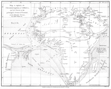 Map showing the Erythraean Sea off the Horn of Africa. Drawn by James Rennell, 1799. | |
| Location | Northwestern Indian Ocean |
| Coordinates | 12°0′N 55°0′E / 12.000°N 55.000°ECoordinates: 12°0′N 55°0′E / 12.000°N 55.000°E |
| Type | Sea |
| Basin countries | Yemen, Somalia |
The Erythraean Sea (Greek: Ἐρυθρὰ Θάλασσα, Erythra Thalassa, "Red Sea") is the name in ancient cartography for a body of water located between the Horn of Africa and the Arabian peninsula. The name is now obsolete.
Etymology
This appellation may have derived from the seasonal blooms of the red-coloured Trichodesmium erythraeum near the water's surface.[1]
In the third century, Flavius Philostratus made this comment: "And they say that the sea called Erythra or "red" is of a deep blue colour, but that it was so named, as I said before, from a King Erythras, who gave his own name to the sea in question." [2]
Use of the name
The name "Erythraean Sea" has been or is still used for the following places:
- In the opening sentences of Herodotus's history, written in the 5th century BC, he refers to the Phoenicians having come originally from the Erythraean Sea.
- In the Periplus of the Erythraean Sea, written in the 1st century AD, as well as in some ancient maps, the name of the sea refers to the whole area of the northwestern Indian Ocean, including the Arabian Sea.[3]
- In centuries past, the name "Erythraean Sea" was applied by cartographers to the NW part of the Indian Ocean, mainly the area around Socotra, between Cape Guardafui and the coast of Hadhramaut. This appellation has now become obsolete and the name Gulf of Aden is used, although for a smaller area. In maps where the NW Indian Ocean is named thus, the Red Sea appears as "Arabian Gulf".
- The name "Erythraean Sea" was used as well to refer to some gulfs attached to the Indian Ocean, specifically, the Persian Gulf.
- As a name for the Red Sea, especially after the 19th century. The modern country of Eritrea was named after this ancient Greek name.
- Since 1895, the name has also been applied to a large dusky region on the surface of planet Mars, known as Mare Erythraeum.
 Names, routes and locations of the Periplus of the Erythraean Sea. |
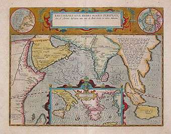 17th-century map depicting the locations of the Periplus of the Erythraean Sea. |
See also
References
- ↑ "Red Sea". Encyclopædia Britannica Online Library Edition. Encyclopædia Britannica. Retrieved 2008-01-14.
- ↑ Life of Apollonius of Tyana, Book III, chapter L, Loeb Classical Library
- ↑ 1794, Orbis Veteribus Notus by Jean Baptiste Bourguignon d'Anville
External links
- The Periplus of the Erythrean sea, containing an account of the navigation of the ancients, from the sea of Suez to the coast of Zanguebar, William Vincent (ed.), 2 voll., London, 1800, vol. 1, vol. 2.
- William H. Schoff, The Periplus of the Erythraean Sea: Travel and Trade in the Indian Ocean by a Merchant of the First Century (New York: Longmans, Green, and Co., 1912), with additional commentary including alternate spellings or translations from Lionel Casson's more recent edition.
This article is issued from Wikipedia - version of the 11/13/2016. The text is available under the Creative Commons Attribution/Share Alike but additional terms may apply for the media files.