Ermelo
| Ermelo | |||
|---|---|---|---|
| Municipality | |||
|
Ermelo town hall | |||
| |||
.svg.png) Location in Gelderland | |||
| Coordinates: 52°18′N 5°37′E / 52.300°N 5.617°ECoordinates: 52°18′N 5°37′E / 52.300°N 5.617°E | |||
| Country | Netherlands | ||
| Province | Gelderland | ||
| Government[1] | |||
| • Body | Municipal council | ||
| • Mayor | Andre Baars (CDA) | ||
| Area[2] | |||
| • Total | 87.33 km2 (33.72 sq mi) | ||
| • Land | 85.62 km2 (33.06 sq mi) | ||
| • Water | 1.71 km2 (0.66 sq mi) | ||
| Elevation[3] | 13 m (43 ft) | ||
| Population (May 2014)[4] | |||
| • Total | 26,121 | ||
| • Density | 305/km2 (790/sq mi) | ||
| Demonym(s) | Ermeloër | ||
| Time zone | CET (UTC+1) | ||
| • Summer (DST) | CEST (UTC+2) | ||
| Postcode | 3850–3853 | ||
| Area code | 0341 | ||
| Website |
www | ||


Ermelo (![]() pronunciation , Dutch Low Saxon: Armelo or Armel) is a municipality and a town in the Netherlands, in the province of Gelderland in the Veluwe area with a population of 26,121 in 2014.
pronunciation , Dutch Low Saxon: Armelo or Armel) is a municipality and a town in the Netherlands, in the province of Gelderland in the Veluwe area with a population of 26,121 in 2014.
Etymology
Ermelo comes from lo, meaning "woods"[5] and irmin for which several explanations are given. Some of those are "great",[5] "divine"[6] or it refers to an old Germanic god called Irmin.[7]
History
The town has been known to exist since at least 855, when the name Irminlo first appeared in a legal document. Human presence in the area goes back further however, with many archaeological finds of the Bell-Beaker culture having been made in the area.
For a long time the town most likely consisted of little more than a few farms and some other buildings like a windmill and a church and it didn't really grow much until the 19th century; in the year 1830 a road was made to make this part of the Veluwe more accessible and at the end of the 19th century the town got a railway station. Because the railway station was some distance away from what was then the town centre a road was constructed, the Stationsstraat, which is now considered to be the centre of the town. After the second world war a shortage of houses resulted in a rapid growth of Ermelo. In 1973 Nunspeet became its own separate municipality after having been part of Ermelo before. In 2005, Ermelo celebrated its 1150-year-long existence. Various artists from across the country performed during the festivities. A classic windmill dating from 1863 located in the town centre, named De Koe (The Cow), partially burned down in 1990 after having been hit by lightning, but was restored to working order in late 2008. A nightclub moved out due to the complete renovation.
Recreation
There are many campsites in the forests surrounding Ermelo which are popular place to stay for mainly Dutch and German tourists. Cycling through the forests and heaths is a popular activity, especially during the summer. The nearby Veluwemeer allows for recreation on the water or beach. The town centre is home to various bars and restaurants and a tourist information centre.
Ermelo hosts various music festivals, such as the Fête de la Musique, Multipop and the International Boogie Woogie Festival. In 2010 the latter featured amongst others pianist Little Willie Littlefield and saxophonist Big Jay McNeely.[8]
Transport
The town's railway station is located near the town centre, with a train normally leaving every 30 minutes during the day both north towards Zwolle and south towards Amersfoort and Utrecht. By car, it can be easily reached from highway A28 which passes west of the town and provincial road N303 which passes through the town. There are also various bus routes passing through the town. Horst, Gelderland is easily accessible from the A28. A pedestrian and cyclist only ferry operates between Horst beach and Zeewolde, crossing the Veluwemeer.
Sports
Ermelo is home to various sports clubs. At the time of UEFA Euro 2000, the Portuguese national team stayed in Ermelo and played against one of the local clubs, DVS'33. This club organizes an annual international tournament for young players.[9] Spanish La Liga football team Valencia CF has regularly used Ermelo as a base for their preseason training, and have played a number of matches at the local ground against other visiting clubs from Europe, such as Lokomotiv Sofia in 2007 and Fenerbahçe in 2006.[10] In May 2009 it became clear that plans for a merge of DVS'33, EFC '58 and KC Ermelo were cancelled.[11]
Population centres


Notable residents
- Eva and Abraham Beem, Dutch Jewish siblings; gassed to death in Auschwitz concentration camp
- Bas Jan van Bochove (born 1950), politician
- Evert ten Napel (born 1944), football commentator
- Martin van der Spoel (born 1971), swimmer
- Aart Vierhouten (born 1970), cyclist
Gallery
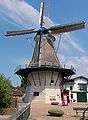 Windmill De Koe (Ermelo)
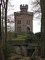 Ermelo water tower
 "Het Boshuis" in Drie (Gelderland)
References
- ↑ "College van B&W" [Board of mayor and aldermen] (in Dutch). Gemeente Ermelo. Retrieved 30 June 2014.
- ↑ "Kerncijfers wijken en buurten" [Key figures for neighbourhoods]. CBS Statline (in Dutch). CBS. 2 July 2013. Retrieved 12 March 2014.
- ↑ "Postcodetool for 3851NT". Actueel Hoogtebestand Nederland (in Dutch). Het Waterschapshuis. Retrieved 30 June 2014.
- ↑ "Bevolkingsontwikkeling; regio per maand" [Population growth; regions per month]. CBS Statline (in Dutch). CBS. 26 June 2014. Retrieved 24 July 2014.
- 1 2 M. Gysseling (1960), Toponymisch Woordenboek van België, Nederland, Luxemburg, Noord-Frankrijk en West-Duitsland (vóór 1226), blz. 327, George Michiels N.V., Tongeren
- ↑ G. van Berkel en K. Samplonius (3de druk 2006), Nederlandse plaatsnamen, herkomst en historie, blz. 130, Het Spectrum, ISBN 978-90-274-2097-8
- ↑ Block, Dirk Peter (1979). De Franken in Nederland (3 ed.). Haarlem: Fibula-Van Dishoeck. p. 67. ISBN 90-228-3739-4.
- ↑ "International Boogie Woogie Festival". Boogiepromotionsholland.nl. Retrieved 2013-08-30.
- ↑ "DVS De Jeugd - Wedstrijden - Toernooien - International Youth tournament". Dvs33.nl. Retrieved 2013-08-30.
- ↑ "Valencia CF, once more in Ermelo, the ideal setting for the élite's training" Valenciacf.es 12 July 2006 Link accessed 28.05.08
- ↑ http://www.ermelo.nl/documenten/internet/overig/nieuwsbrief%20ermelo%20project/Nieuwsbrief%20projecten%20nr%201.pdf
External links
 Media related to Ermelo at Wikimedia Commons
- Official website (Dutch)
 |
Zeewolde (FL) / Nuldernauw | Harderwijk | Nunspeet | |
| |
||||
| ||||
| | ||||
| Putten | Barneveld | Apeldoorn |
