North Epping, New South Wales
| North Epping Sydney, New South Wales | |||||||||||||
|---|---|---|---|---|---|---|---|---|---|---|---|---|---|
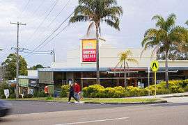 North Epping retail area | |||||||||||||
| Population | 4,393 (2011 census)[1] | ||||||||||||
| • Density | 1,910/km2 (4,950/sq mi) | ||||||||||||
| Established | 1899 | ||||||||||||
| Postcode(s) | 2121 | ||||||||||||
| Area | 2.3 km2 (0.9 sq mi) | ||||||||||||
| Location | 19 km (12 mi) from Sydney CBD | ||||||||||||
| LGA(s) | Hornsby Shire | ||||||||||||
| State electorate(s) | Epping | ||||||||||||
| Federal Division(s) | Bennelong | ||||||||||||
| |||||||||||||

North Epping is a suburb of Sydney, in the state of New South Wales, Australia 19 kilometres north-west of the Sydney central business district in the local government area of Hornsby Shire. North Epping is in the Northern Suburbs region. Epping is a separate suburb to the south, which shares the postcode of 2121.
North Epping is a leafy suburb, surrounded by bushland of the upper section of Lane Cove National Park. There are many walking trails, including the Great North Walk. One of the well known landmarks is Whale Rock.
History
Aboriginal culture
The Wallumedegal Aboriginal tribe lived in the area between the Lane Cove River and Parramatta River, which was known as Walumetta.[2]
European settlement
In 1792 Governor Phillip began the granting of parcels of lands to marines, and the area was referred to on Phillip's maps as the Field of Mars, named after the Roman Field of Mars probably because of the military link. It contained the area of what is now Epping and North Epping. The name Epping is derived from Epping Forest in Essex, England.[3]
Lin family murder
In the early hours of 18 July 2009, the Lin family, consisting of Min Lin, Yun Li Lin, her sister Yun Lin, and the parents' two children Henry and Terry Lin, were all murdered at their home on Boundary Road, North Epping. Robert Xie was arrested at his home in North Epping on 5 May 2011 at 9.00am for killing the family. He is currently on trial. Brenda Lin, the last living member of the family, lived with the alleged killer and his wife for 22 months. A funeral was held for the family at Sydney Olympic Park, New South Wales on 8 August 2009.
Becoming a separate suburb
North Epping was split off from Epping as a separate suburb on 1 December 1995.[4]
Commercial area
North Epping has a small shopping centre located on the corner of Roma Street and Malton Road. It features a number of specialty shops, cafes and restaurants. North Epping also has a small school - Epping North Public School. North Epping has many parks, many community areas and gatherings.
Transport
The M2 Hills Motorway runs along the southern border to the Sydney CBD. North Epping is connected to adjacent Epping by a single road, Norfolk Road. Norfolk Road runs south towards Epping Road, a major arterial road in the area that runs east to the Pacific Highway. Almost all areas of the suburb are serviced by Sydney Buses route 295 (Macquarie Centre to North Epping). The route is a loop and only goes clockwise around the edge of the suburb- the only place where it runs in both directions is Norfolk road south of Grayson street, towards Epping railway station.
At the 2011 census, 22.1% of employed people travelled to work on public transport and 56.1% by car (either as driver or as passenger).
Demographics
At the 2011 census, North Epping recorded a population of 4,393. Of these:[1]
- Age distribution
- The distribution of ages in North Epping shows slightly more young families than the country as a whole. North Epping residents' median age was 41 years, compared to the national median of 37. Children aged 0–14 years made up 21.2% of the population (national average is 19.3%) and people aged 65 years and over made up 15.8% of the population (national average is 14.0%).
- Ethnic diversity
- Just over two-thirds (67.1%) of residents were born in Australia; the next most common countries of birth were China 4.6%, England 3.6%, India 3.3%, Hong Kong 2.5% and South Korea 2.2%. Almost three-quarters (73.4%) spoke only English at home; other languages spoken at home included Cantonese 5.6%, Mandarin 4.3%, Korean 2.7%, Hindi 1.7% and Italian 0.8%.
- Income
- The average weekly household income was $2,038, well above the national average of $1,234.
- Housing
- The majority of dwellings (92.9%) were separate houses, 6.7% were semi-detached, and just 0.3% were flats, units or apartments. 83.2% were family households, and the average household size was 3.0 people.
Politics
North Epping is under the municipal authority of Ward C in the Hornsby Shire Council, is part of the federal electorate of Bennelong and State electorate of Epping.
References
- 1 2 Australian Bureau of Statistics (31 October 2012). "North Epping (State Suburb)". 2011 Census QuickStats. Retrieved 7 November 2012.
- ↑ Smith, Keith Vincent (2005). Wallumedegal : an Aboriginal history of Ryde. North Ryde, N.S.W.: Community Services Unit, City of Ryde. ISBN 9780959941999.
- ↑ The Book of Sydney Suburbs, Compiled by Frances Pollon, Angus & Robertson Publishers, 1990, Published in Australia ISBN 0-207-14495-8
- ↑ "GEOGRAPHICAL NAMES REGISTER EXTRACT". Reference: 74057, GNB File: GNB3707: Geographical Names Board of New South Wales. Retrieved 21 April 2014.
External links
| Wikimedia Commons has media related to North Epping, New South Wales. |
- Niall Clugston - Hornsby Shire Library (2008). "North Epping". Dictionary of Sydney. Retrieved 28 September 2015. [CC-By-SA]
Coordinates: 33°45′44″S 151°06′04″E / 33.7623°S 151.1010°E