Ephrata, Pennsylvania
| Ephrata | |
|---|---|
| Borough | |
|
Main Street during the Ephrata Fair | |
| Etymology: Ephrath | |
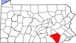
 Location of Ephrata in Lancaster County | |
 Ephrata Location of Ephrata in Pennsylvania | |
| Coordinates: 40°10′51″N 76°10′57″W / 40.18083°N 76.18250°WCoordinates: 40°10′51″N 76°10′57″W / 40.18083°N 76.18250°W | |
| Country | United States |
| State | Pennsylvania |
| County | Lancaster |
| Incorporated | 22 August 1891 |
| Government | |
| • Mayor | Ralph Mowen |
| Area | |
| • Total | 1.9 sq mi (5 km2) |
| • Land | 1.5 sq mi (4 km2) |
| • Water | 0.0 sq mi (0 km2) |
| Elevation | 358 ft (109 m) |
| Population (2010) | |
| • Total | 13,394 |
| • Density | 7,000/sq mi (2,700/km2) |
| Time zone | EST (UTC-5) |
| • Summer (DST) | EDT (UTC-4) |
| ZIP code | 17522 |
| Area code(s) | 717 Exchanges: 721, 733, 738 |
| Website | http://ephrataboro.org |

Ephrata (English: /ˈɛfrətə/ EF-rə-tə, Pennsylvania German: Effridaa) is a borough in Lancaster County, Pennsylvania, United States, 38 miles (61 km) south east of Harrisburg and about 57 miles (92 km) west by north of Philadelphia. It is named after Ephrath, a biblical town in what is now Israel.[1] Ephrata's sister city is Eberbach, Germany, the city where its founders originated. In its early history, Ephrata was a pleasure resort and an agricultural community.
Ephrata's population has steadily grown over the last century. In 1900, 2,452 people lived there, in 1910, 3,192, and by 1940, the population had increased to 6,199. The population was 13,394 at the 2010 census. Ephrata is the most populous borough in Lancaster County.
History

Ephrata is noteworthy for having been the former seat of the Mystic Order of the Solitary, a semimonastic order of Seventh-Day Dunkers. The community, which contained both men and women, was founded by Johann Conrad Beissel in 1732.
Many of the members were well-educated; Peter Miller, second prior of the monastery, translated the Declaration of Independence into seven languages, at the request of Congress. At the period of its greatest prosperity the community contained nearly 300 persons.[2][3]
The Ephrata Commercial Historic District, Ephrata Cloister, Eby Shoe Corporation buildings, Connell Mansion, Mentzer Building, and Mountain Springs Hotel are listed on the National Register of Historic Places.[4]
Geography
Ephrata is located at 40°10′51″N 76°10′57″W / 40.18083°N 76.18250°W (40.17870, -76.17744).[5]
Like the rest of the county, it is mostly flat land suitable for farming.
According to the United States Census Bureau, the borough has a total area of 3.6 square miles (9.3 km2), of which, 3.6 square miles (9.3 km2) of it is land and 0.28% is water.
Demographics
| Historical population | |||
|---|---|---|---|
| Census | Pop. | %± | |
| 1880 | 392 | — | |
| 1900 | 2,451 | — | |
| 1910 | 3,192 | 30.2% | |
| 1920 | 3,735 | 17.0% | |
| 1930 | 4,988 | 33.5% | |
| 1940 | 6,199 | 24.3% | |
| 1950 | 7,027 | 13.4% | |
| 1960 | 7,688 | 9.4% | |
| 1970 | 3,532 | −54.1% | |
| 1980 | 4,789 | 35.6% | |
| 1990 | 7,116 | 48.6% | |
| 2000 | 13,213 | 85.7% | |
| 2010 | 13,394 | 1.4% | |
| Est. 2015 | 13,861 | [6] | 3.5% |
| Sources:[7][8][9] | |||
As of the census[8] of 2000, there were 13,213 people, 5,477 households, and 3,565 families residing in the borough. The population density was 3,672.7 people per square mile (1,417.1/km²). There were 5,672 housing units at an average density of 1,576.6 per square mile (608.3/km²). The racial makeup of the borough was 96.10% White, 0.64% Black or African American, 0.26% Native American, 1.06% Asian, 0.14% Pacific Islander, 0.82% from other races, and 0.98% from two or more races. 2.75% of the population were Hispanic or Latino of any race.
There were 5,477 households, out of which 30.1% had children under the age of 18 living with them, 52.6% were married couples living together, 8.6% had a female householder with no husband present, and 34.9% were non-families. 28.6% of all households were made up of individuals, and 11.1% had someone living alone who was 65 years of age or older. The average household size was 2.38 and the average family size was 2.94.
In the borough the population was spread out, with 24.0% under the age of 18, 8.5% from 18 to 24, 32.1% from 25 to 44, 21.6% from 45 to 64, and 13.9% who were 65 years of age or older. The median age was 36 years. For every 100 females there were 95.6 males. For every 100 females age 18 and over, there were 92.7 males.
The median income for a household in the borough was $41,550, and the median income for a family was $48,213. Males had a median income of $35,095 versus $22,782 for females. The per capita income for the borough was $19,659. About 3.7% of families and 6.2% of the population were below the poverty line, including 5.5% of those under age 18 and 7.4% of those age 65 or over.
Community Pool
The Borough of Ephrata own and operate the Ephrata Community Pool which is located at 418 Vine Street. Currently, the pool is the oldest continuously operated swimming pool in Lancaster County, finishing its 84th year of operation in September 2015. A newly remodeled pool opened on May 26, 2012. This pool contains zero-depth entries, flume slides, and climbing walls among other things.
Schools
Schools in Ephrata are part of Ephrata Area School District also known as E.A.S.D P.A
Elementary
Middle
High
Economy

In August 2011 a luxury rehab opened adding over 175 new jobs
Ephrata has a mix of large and small businesses of many types.
Religion
Ephrata has a diverse mix of churches and faith groups, primarily Christian.
Public services


The Ephrata Public Library,[10] located on South Reading Road, is a member of the Library System of Lancaster County.
Law and government
Ephrata is a borough. The current mayor of Ephrata is Mayor Ralph Mowen. His term expires in December 2017.
The name 'Ephrata' is also used to refer to the surrounding Ephrata Township, Pennsylvania.
Elected officials representing Ephrata
- Pennsylvania Governor Tom Wolf (D)
- Senior United States Senator Bob Casey, Jr. (D)
- Junior United States Senator Patrick Toomey (R)
- United States Congressman Joseph R. Pitts (R)
- Pennsylvania State Senator David Zimmerman (R)
- Pennsylvania State Representative Ryan Aument (R)
- Ephrata Borough Council: Susan Rowe, President; Thomas Reinhold, Vice-President; Victor Richard, Melvin Weiler, Tim Barr, Linda Martin, Ricky Ressler, Gregory Zimmerman
- Ephrata Mayor Ralph Mowen (R)
Notable people
- Richard D. Winters, Major, "E" Company, 2nd Battalion, 506th Parachute Infantry Regiment, 101st Airborne Division
- Evelyn Margaret Ay, Miss America 1954
- Mike Mentzer, professional bodybuilder and 1979 Mr. Olympia heavyweight champion[11]
- Murray Merle Schwartz, United States District Court judge
- Texas In July, Metalcore band
- Charles B. McVay III, Rear Admiral & Commanding Officer, USS Indianapolis (CA-35) at time of sinking in 1945.
Sites of interest
Museums and historic sites
- Eicher Arts Center – Occupies Conrad Beissel's historic Eicher House. It also contains an Indian (Native American) museum and shop.
- Ephrata Cloister
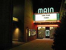
- Main Theater – The Main Theater, built by the Stiefel brothers, held its grand opening Christmas Day in 1938. The first film to show was Just Around the Corner starring Shirley Temple. In 1990, the Denver and Ephrata Telephone Company purchased the theater to restore the building and once again provide movies and live productions to the area, with many original fixtures incorporated into the renovated venue.[12] The theater reopened 12 November 1993.
- Mountain Springs Hotel – The site of the former hotel stands at the corner of Main Street (U.S. Route 322) and Spring Garden Street. Unoccupied for a long period of time, it was torn down in 2004, except for a small portion of the original building, which was preserved and renovated to be used as a conference center and, possibly, as a museum. A Hampton Inn was constructed at the site in September 2005. An Applebee's restaurant was also built, and there are plans for an office building.
- Ephrata Performing Arts Center – The Ephrata Performing Arts Center (known as EPAC), started as the Legion Star Playhouse in 1953 under the direction of John Cameron. In 1972, following Cameron's departure, volunteers took over the production of regular shows, and eventually incorporated as a non-profit in 1979, the first season under the name of EPAC came in 1980. Following a 2.4 million dollar renovation, the community theater was able to and still produces year round theater, including plays, musicals, a children's series, regular educational opportunities (including a summer theater camp), and special performances.
Area attractions
- The Ephrata Fair – is the largest street fair in Pennsylvania, the fair dates back to October 1919, when local businessmen organized a one-day festivity to commemorate World War I veterans. Over the following years, the fair grew to include farmers celebrating the harvest; and it also grew in duration by several days. The popular parade was added in 1932. Today, the fair is held for five days during every September and attracts tens of thousands of visitors every year.[13]
Sister city
Ephrata has one sister city, as designated by Sister Cities International:
-
 Eberbach, Baden-Württemberg, Germany
Tornado
On Sunday, 29 March 2009, a strong storm briefly swept through Ephrata. On 31 March, the National Weather Service confirmed that it was an EF1 tornado. Strong hail came with it. Although there were no fatalities, 30 homes were damaged and 8 mobile homes were destroyed. Many vehicles could be seen on their side afterwards, and holes were put in houses from the hail.[14]
References
- ↑ Gannett, Henry (1905). The Origin of Certain Place Names in the United States. Govt. Print. Off. p. 120.
- ↑ Gibbons, Phebe Earle (1872). Pennsylvania Dutch and Other Essays. Philadelphia: J.B. Lippincott. OCLC 128259577.
- ↑ Sachse, Julius Friedrich (1899–1900). The German Sectarians of Pennsylvania: A Critical and Legendary History of the Ephrata Cloister and the Dunkers. Philadelphia: Printed for the author. OCLC 2030149.
- ↑ National Park Service (2010-07-09). "National Register Information System". National Register of Historic Places. National Park Service.
- ↑ "US Gazetteer files: 2010, 2000, and 1990". United States Census Bureau. 2011-02-12. Retrieved 2011-04-23.
- ↑ "Annual Estimates of the Resident Population for Incorporated Places: April 1, 2010 to July 1, 2015". Retrieved July 2, 2016.
- ↑ "Census of Population and Housing". U.S. Census Bureau. Retrieved 11 December 2013.
- 1 2 "American FactFinder". United States Census Bureau. Retrieved 2008-01-31.
- ↑ "Incorporated Places and Minor Civil Divisions Datasets: Subcounty Resident Population Estimates: April 1, 2010 to July 1, 2012". Population Estimates. U.S. Census Bureau. Retrieved 11 December 2013.
- ↑ Ephratapubliclibrary.org
- ↑ Mike Mentzer
- ↑ "The Main Theater". Borough of Ephrata. 19 December 2008. Retrieved 2009-12-06.
- ↑ "About Us". Ephrata Fair.
- ↑ "National and Local Weather Forecast, Hurricane, Radar and Report" (Flash video). Weather.com. 31 March 2009.
External links
![]() Media related to Ephrata, Pennsylvania at Wikimedia Commons
Media related to Ephrata, Pennsylvania at Wikimedia Commons