Entrance Road
| ||||
|---|---|---|---|---|
| Entrance Road | ||||
| Route information | ||||
| Maintained by WYDOT & NPS | ||||
| Length: | 0.585 mi[1] (0.941 km) | |||
| Existed: | 1917 – present | |||
| Major junctions | ||||
| East end: |
| |||
| West end: | Devils Tower National Monument Entrance | |||
| Location | ||||
| Counties: | Crook | |||
| Highway system | ||||
| ||||
|
Entrance Road--Devils Tower National Monument | ||||
| Location | Devils Tower National Monument, Devils Tower, Wyoming | |||
| Area | 3 miles (4.8 km) | |||
| Built | 1934 | |||
| Architect | NPS Branch of Plans and Design | |||
| Architectural style | Other | |||
| MPS | Devils Tower National Monument MPS | |||
| NRHP Reference # | 00000854 | |||
| Added to NRHP | July 24, 2000[2][3] | |||

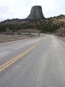
The Entrance Road at Devils Tower National Monument, officially known as Wyoming Highway 110, is a scenic road that provides the approach to the Devil's Tower eminence, affording planned views to arriving visitors.
Route description
The Wyoming Highway 110 designation is a short 0.59-mile-long (950 m) roadway that starts its at Wyoming Highway 24 and travels west to the Devils Tower National Monument Entrance. Mileposts along WYO 110 increase from east to west.
The entrance road is a 3-mile (4.8 km) long, two-lane, asphalt paved road that spans the distance between the Entrance Station and the visitor parking area located just west of Devil's Tower. The road provides access to the monument's primary developed areas, such as headquarters and visitor center.
History
The road was originally constructed in 1917 with an eight percent grade and a ford at the Belle Fourche River. A bridge was built in 1928, and the road was extensively altered in the 1930s with labor from the Civilian Conservation Corps, improving grades and alignments.[3] CCC camp NM-1 remained at Devil's Tower from 1935 to 1938.[4] A complete loop was planned by the National Park Service Engineering Division in 1927, but was never carried out. The entrance road at Devils Tower is listed on the National Register of Historic Places as an example of close integration with the natural surroundings.[5][6]
Much of the CCC work involved realignment of the existing road and the careful obliteration of the old alignment, using young trees and sod stockpiled during construction of the new alignment.[6]
Major intersections
The entire route is in Crook County.
| Location | mi[1] | km | Destinations | Notes | |
|---|---|---|---|---|---|
| Devils Tower | 0.000 | 0.000 | Eastern terminus of WYO 110 | ||
| Devils Tower National Monument | 0.585 | 0.941 | Devils Tower National Monument boundary | Western terminus of WYO 110 | |
| 1.000 mi = 1.609 km; 1.000 km = 0.621 mi | |||||
See also
- Entrance Station-Devils Tower National Monument
- Old Headquarters Area Historic District
- Tower Ladder-Devils Tower National Monument
References
- 1 2 Maintenance Staff (February 2013). "Maintenance Section Reference Book" (PDF). Wyoming Department of Transportation. Retrieved December 18, 2013.
- ↑ National Park Service (July 9, 2010). "National Register Information System". National Register of Historic Places. National Park Service.
- 1 2 "Entrance Road". List of Classified Structures. National Park Service. November 9, 2008.
- ↑ "First Fifty Years: The 1930s". Devils Tower National Monument. National Park Service. November 8, 2008.
- ↑ "Devils Tower Entrance Road". National Register of Historic Places. Wyoming State Preservation Office. November 8, 2008.
- 1 2 McKoy, Kathy (January 31, 1996). "National Register of Historic Places Inventory-Nomination: Entrance Road" (PDF). National Park Service.
External links
 Media related to National Register of Historic Places in Devils Tower National Monument at Wikimedia Commons
- National Park Service Devils Tower First Fifty Years: The Early Years
- Devils Tower Entrance Road at Wyoming State Historic Preservation Office