Ensenada Partido
| Ensenada Partido de Ensenada | |
|---|---|
| Department | |
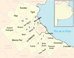
 location of Ensenada Partido in Gran Buenos Aires | |
| Country | Argentina |
| Seat | Ensenada |
| Government | |
| • Mayor | Mario Carlos Secco, Partido Vecinal |
| Area | |
| • Total | 135 km2 (52 sq mi) |
| Population | |
| • Total | 51,448 |
| • Density | 380/km2 (990/sq mi) |
| Demonym(s) | ensenadense |
| Postal Code | B1925 |
| IFAM | BUE035 |
| Area Code | 02221 |
| Coordinates | 34°52′S 57°54′W / 34.867°S 57.900°W |
| Website | http://www.ensenada.gov.ar |
Ensenada Partido (Spanish pronunciation: [enseˈnaða]) is a district (a "partido") of Buenos Aires Province, Argentina, belonging to the Greater La Plata area, just south of the Gran Buenos Aires urban conglomerate.
The provincial district has a population of about 51,448 inhabitants in an area of only 135 km2 (52 sq mi); its capital city is Ensenada, located 27 km (17 mi) from Buenos Aires and 5 km from La Plata.
History
The district spans the area historically known as Ensenada de Barragán (Barragán's Cove). The old coastal site forms part of what is today Santiago Island. A military battery and defensive wall was built there in the early 18th century, known as Fuerte Barragán (Fort Barragán). On 5 May 1801 Viceroy Marqués de Avilés founded the village of Ensenada. In 1882, the government of Dardo Rocha declared it as temporary provincial capital while the new city of La Plata was being built.
Settlements
- Ensenada
- Punta Lara
- Villa Catella
- Dique Nº 1
- Isla Santiago
External links
- (Spanish) Information about Ensenada