Enneüs Heerma Bridge
| Enneüs Heerma Bridge | |
|---|---|
 | |
| Coordinates | 52°21′54″N 4°58′36″E / 52.36500°N 4.97667°ECoordinates: 52°21′54″N 4°58′36″E / 52.36500°N 4.97667°E |
| Carries | Road traffic and light rail |
| Locale | Amsterdam, Netherlands |
| Characteristics | |
| Material | Steel |
| Total length | 230 metres (750 ft) |
| Width | 38 metres (125 ft) |
| Height | 26 metres (85 ft) |
| History | |
| Designer | Grimshaw Architects |
| Opened | 2001 |
The Enneüs Heerma Bridge (Dutch: Enneüs Heermabrug) is a bridge in the Netherlands which connects the new urban district of IJburg, built on seven artificial islands in IJ Lake, with the isle of Zeeburg, a borough on the eastern edge of Amsterdam, the capital of the Netherlands.
The bridge is named after Enneüs Heerma, the late Christian Democrat, alderman and Secretary of State of the Netherlands.
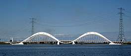
Made of steel, with a length of 230 metres (750 ft), a width of 38 metres (125 ft), and a height of 26 metres (85 ft), the suspended deck of the bridge serves to carry a traffic road and a light rail (tram) line. It is the main connection between IJburg and the A10 and can be reached by tram 26 from Amsterdam Centraal Station.
Completed in 2001, the bridge was designed by Grimshaw Architects. The classic gables of Amsterdam’s canal houses inspired the arches and lateral gables and the wavy patterns refer to water. The segmented appearance is based on the skeleton of a crab. The shallowness of the water at the bridge site made it impossible to use floating cranes to lift the pre-assembled arches of the bridge into position during construction. The problem was solved by using pontoons and crawler cranes.
See also
- The Nescio Bridge cycle and footbridge connecting IJburg to East Amsterdam
- List of bridges
External links
- Picture from the architectural firm's website
- www.ijburg.nu, Who is Enneus Heerma? Discussion about the bridge (in Dutch)
- Enneüs Heerma Bridge at Structurae
| Wikimedia Commons has media related to Enneüs Heerma Bridge. |