Enkhuizen
| Enkhuizen | |||
|---|---|---|---|
| Municipality | |||
|
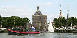
Harbour of Enkhuizen | |||
| |||
.svg.png) Location in North Holland | |||
| Coordinates: 52°42′N 5°18′E / 52.700°N 5.300°ECoordinates: 52°42′N 5°18′E / 52.700°N 5.300°E | |||
| Country | Netherlands | ||
| Province | North Holland | ||
| Government[1] | |||
| • Body | Municipal council | ||
| • Mayor | Jan Baas (PvdA) | ||
| Area[2] | |||
| • Total | 116.25 km2 (44.88 sq mi) | ||
| • Land | 12.42 km2 (4.80 sq mi) | ||
| • Water | 103.83 km2 (40.09 sq mi) | ||
| Elevation[3] | 3 m (10 ft) | ||
| Population (May 2014)[4] | |||
| • Total | 18,383 | ||
| • Density | 1,480/km2 (3,800/sq mi) | ||
| Demonym(s) | Enkhuizer | ||
| Time zone | CET (UTC+1) | ||
| • Summer (DST) | CEST (UTC+2) | ||
| Postcode | 1600–1602 | ||
| Area code | 0228 | ||
| Website |
www | ||

Enkhuizen [ɛŋkˈɦœy̯zə(n)] is a municipality and a city in the Netherlands, in the province of North Holland and the region of West-Frisia.
History
| Historical population | ||
|---|---|---|
| Year | Pop. | ±% p.a. |
| 1398 | 1,900 | — |
| 1477 | 3,500 | +0.78% |
| 1494 | 3,175 | −0.57% |
| 1514 | 3,600 | +0.63% |
| 1553 | 4,450 | +0.54% |
| 1557 | 5,500 | +5.44% |
| 1561 | 7,750 | +8.95% |
| 1622 | 21,878 | +1.72% |
| 1632 | 19,150 | −1.32% |
| 1732 | 10,420 | −0.61% |
| 1795 | 6,803 | −0.67% |
| Source: Lourens & Lucassen 1997, pp. 59–60 | ||
Enkhuizen was one of the harbour-towns of the VOC, just like Hoorn and Amsterdam, from where overseas trade with the East Indies was conducted. It received city rights in 1355. In the mid-17th century, Enkhuizen was at the peak of its power and was one of the most important harbour cities in the Netherlands. However, due to a variety of reasons, notably the silting up of the harbours, Enkhuizen lost its position to Amsterdam.
Tourism
Enkhuizen has one of the largest marinas in the Netherlands. Zuiderzeemuseum is located in Enkhuizen. Architecturally, the Drommedaris is the oldest building in Enkhuizen, from 1540. Tourists take boat trips to and from the port to Medemblik.[5]
Industry
Industrially, Enkhuizen is home to a number of seed production companies, as well as a plastics factory. Tourism is a large part of the economy, too.
Population centres
The municipality of Enkhuizen consists of the following cities, towns, villages and/or districts: Enkhuizen, Oosterdijk, Westeinde.
Local government
The municipal council of Enkhuizen consists of 17 seats, which are divided as follows:
- SP - 3 seats
- VVD/D66 - 3 seats
- PvdA - 3 seats
- Nieuw Enkhuizen - 3 seats
- CDA - 2 seats
- ChristenUnie/SGP - 1 seat
- Lijst Quasten - 1 seat
- GroenLinks - 1 seat
Gallery
 Enkhuizen, railway station
 Enkhuizen, gate: de Koepoort
 Enkhuizen, town gate: de Drommedaris
 Enkhuizen in winter
 Historic map of Enkhuizen
Transport
Enkhuizen station offers direct rail service to Hoorn, Amsterdam and Amersfoort, with the journey to Amsterdam Centraal of around an hour.
Furthermore, during summer ferries for pedestrians and cyclists operate between Enkhuizen and Stavoren; between Enkhuizen and Medemblik; and between Enkhuizen and Urk.
It is also possible to drive or cycle across the Houtribdijk to Lelystad, passing under naviduct near the Krabbersgat lock.
Notable residents
- Gerbrand Bakker (1771–1828), physician, professor at the University of Groningen
- Lucas Janszoon Waghenaer (1533/34–1606), chief officer, cartographer
- Paulus Potter (1625–1654), painter
- Gerrit Zalm (born 1952), banker, former minister of finance
- Wijda Mazereeuw (born 1953), swimmer
References
- ↑ "De burgemeester" [The mayor] (in Dutch). Gemeente Enkhuizen. Retrieved 3 March 2014.
- ↑ "Kerncijfers wijken en buurten" [Key figures for neighbourhoods]. CBS Statline (in Dutch). CBS. 2 July 2013. Retrieved 12 March 2014.
- ↑ "Postcodetool for 1601KA". Actueel Hoogtebestand Nederland (in Dutch). Het Waterschapshuis. Retrieved 3 March 2014.
- ↑ "Bevolkingsontwikkeling; regio per maand" [Population growth; regions per month]. CBS Statline (in Dutch). CBS. 26 June 2014. Retrieved 24 July 2014.
- ↑ DK Eyewitness Travel Guide: The Netherlands: The Netherlands. DK Publishing. 1 August 2011. p. 178. ISBN 978-0-7566-8476-1.
Literature
- Lourens, Piet; Lucassen, Jan (1997). Inwonertallen van Nederlandse steden ca. 1300–1800. Amsterdam: NEHA. ISBN 9057420082.
External links
-
 Media related to Enkhuizen at Wikimedia Commons
 -
 Enkhuizen travel guide from Wikivoyage
 - Official website
 |
IJsselmeer | | ||
| Medemblik Stede Broec |
|
IJsselmeer | ||
| ||||
| | ||||
| Markermeer |
