Engelthal
| Engelthal | ||
|---|---|---|
|
Gate in Engelthal | ||
| ||
 Engelthal | ||
Location of Engelthal within Nürnberger Land district 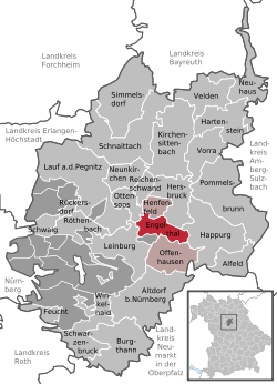 | ||
| Coordinates: 49°28′N 11°24′E / 49.467°N 11.400°ECoordinates: 49°28′N 11°24′E / 49.467°N 11.400°E | ||
| Country | Germany | |
| State | Bavaria | |
| Admin. region | Mittelfranken | |
| District | Nürnberger Land | |
| Municipal assoc. | Henfenfeld | |
| Government | ||
| • Mayor | Günther Rögner (CSU) | |
| Area | ||
| • Total | 13.63 km2 (5.26 sq mi) | |
| Population (2015-12-31)[1] | ||
| • Total | 1,124 | |
| • Density | 82/km2 (210/sq mi) | |
| Time zone | CET/CEST (UTC+1/+2) | |
| Postal codes | 91238 | |
| Dialling codes | 09158 | |
| Vehicle registration | LAU, ESB, HEB, N, PEG | |
| Website | www.engelthal.de | |
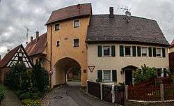

Engelthal is a municipality near Nürnberg (Nuremberg) in the Frankenalb (Frankish Alb). The municipality has a population of approximately 1100 people. It was established as a cloister around 1250 AD and has retained many of the original cloister buildings. In recent years, residents have remodeled and restored sections of the cloister and cloister wall.
Cultural references
- Engelthal is mentioned in chapter XXIII of Henry James's 1875 novel Roderick Hudson, '[...] the eggs of Engelthal were almost as fresh and the cream almost as thick as those of the Connecticut Valley.'.
- Engelthal is one of the settings in The Gargoyle by Andrew Davidson, where one of the main characters, Marianne Engel, is raised as a nun.
References
- ↑ "Fortschreibung des Bevölkerungsstandes". Bayerisches Landesamt für Statistik und Datenverarbeitung (in German). June 2016.
External links
This article is issued from Wikipedia - version of the 3/22/2016. The text is available under the Creative Commons Attribution/Share Alike but additional terms may apply for the media files.