Empurany
| Empurany | |
|---|---|
|
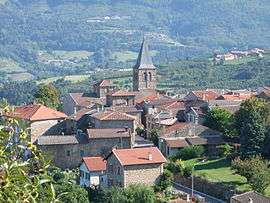
The church and surroundings in Empurany | |
 Empurany | |
|
Location within Auvergne-Rhône-Alpes region  Empurany | |
| Coordinates: 45°01′31″N 4°36′34″E / 45.0253°N 4.6094°ECoordinates: 45°01′31″N 4°36′34″E / 45.0253°N 4.6094°E | |
| Country | France |
| Region | Auvergne-Rhône-Alpes |
| Department | Ardèche |
| Arrondissement | Tournon-sur-Rhône |
| Canton | Lamastre |
| Government | |
| • Mayor (2008–2014) | Michel Lassara |
| Area1 | 18.94 km2 (7.31 sq mi) |
| Population (2008)2 | 543 |
| • Density | 29/km2 (74/sq mi) |
| Time zone | CET (UTC+1) |
| • Summer (DST) | CEST (UTC+2) |
| INSEE/Postal code | 07085 / 07270 |
| Elevation |
310–1,028 m (1,017–3,373 ft) (avg. 500 m or 1,600 ft) |
|
1 French Land Register data, which excludes lakes, ponds, glaciers > 1 km² (0.386 sq mi or 247 acres) and river estuaries. 2 Population without double counting: residents of multiple communes (e.g., students and military personnel) only counted once. | |
Empurany is a commune in the Ardèche department in southern France.
Population
| Historical population | ||
|---|---|---|
| Year | Pop. | ±% |
| 1962 | 685 | — |
| 1968 | 770 | +12.4% |
| 1975 | 696 | −9.6% |
| 1982 | 631 | −9.3% |
| 1990 | 546 | −13.5% |
| 1999 | 492 | −9.9% |
| 2008 | 543 | +10.4% |
See also
References
| Wikimedia Commons has media related to Empurany. |
This article is issued from Wikipedia - version of the 2/12/2016. The text is available under the Creative Commons Attribution/Share Alike but additional terms may apply for the media files.