Coos Bay, Oregon
| Coos Bay, Oregon | |
|---|---|
| City | |
|
Tioga Building | |
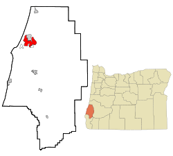 Location in Oregon | |
| Coordinates: 43°22′35″N 124°14′14″W / 43.37639°N 124.23722°WCoordinates: 43°22′35″N 124°14′14″W / 43.37639°N 124.23722°W | |
| Country | United States |
| State | Oregon |
| County | Coos |
| Government | |
| • Mayor | Joe Benetti [1] |
| Area[2] | |
| • Total | 15.90 sq mi (41.18 km2) |
| • Land | 10.60 sq mi (27.45 km2) |
| • Water | 5.30 sq mi (13.73 km2) |
| Elevation | 23 ft (7 m) |
| Population (2010)[3] | |
| • Total | 15,967 |
| • Estimate (2012[4]) | 15,857 |
| • Density | 1,506.3/sq mi (581.6/km2) |
| Time zone | Pacific (UTC-8) |
| • Summer (DST) | Pacific (UTC-7) |
| ZIP code | 97420 |
| Area code(s) | 458 and 541 |
| FIPS code | 41-15250[3] |
| GNIS feature ID | 1166633[5] |
| Website | www.coosbay.org |
_(cooDA0004).jpg)
_(cooD0088).jpg)
Coos Bay (Coos language: Atsixiis[6]) is a city located in Coos County, Oregon, United States, where the Coos River enters Coos Bay on the Pacific Ocean. The city borders the city of North Bend, and together they are often referred to as one entity called either Coos Bay-North Bend or the Bay Area. Coos Bay's population as of the 2010 census was 15,967 residents, making it the largest city on the Oregon Coast.[7][8]
History
Prior to Europeans first visiting the Oregon coast, Native American tribes claimed the Coos Bay region as their homeland for thousands of years.[9] Members of the Coos, Lower Umpqua, Siuslaw and Coquille tribes lived, fished, hunted and gathered along Coos Bay and its estuaries, along rivers, and in meadows and forests.[9] Approximately 400 years ago, British and Spanish explorers first approached the South Coast.[9] In 1579 Sir Francis Drake is purported to have sought shelter for his ship, the Golden Hinde, around Cape Arago.[10][11] Trader and explorer Jedediah Smith was in the region seeking furs and the Hudson's Bay Company sent Alexander McLeod to search for an inland passage.[9]
19th century

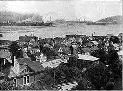
The earliest settlement of European Americans in the area was in January 1852 when survivors of the Captain Lincoln shipwreck established Camp Castaway until they and their cargo could be fully rescued.[12][13] There has been a permanent settlement on Coos Bay since 1853, when the town of Marshfield was founded there and named after the Massachusetts hometown of its founder, J. C. Tolman.[11] The first Methodist church in the area was established in 1857.[14] By 1866 the inhabitants, who were reliant on the sea for their income, had built the Cape Arago Light. The setting up of a post office in 1871 and the arrival of the Coos Bay Wagon Road in the town a year later connected Coos County with the Umpqua River valley in neighbouring Douglas County, on the other side of the Coast Range of mountains. This wagon road, although long gone in its original form, is still partially in existence since the route of Oregon Route 42 roughly follows the original right of way.
1869 saw Coos Bay set up its first, and the state's 48th, chartered Masonic Lodge.[15] Named Blanco Lodge, this brotherhood was set up by several of the town's founding fathers. With this development, the incorporation of Marshfield came in 1874. One of the nation's oldest still-operating machine shops, the Nelson Machine Works-Coos Bay Iron Works, was founded in 1888.
20th century
In 1902 the only lynching ever to be documented in Oregon occurred in Coos Bay, of Alonzo Tucker, an African American man. He was accused of raping a white woman and escaping from jail. However, there is no record of his escape from jail. The only account is that he was caught by a mob of 200 to 300 people, shot twice and hung from the 7th Street bridge, which spanned present day Golden Field, where high school soccer games are now held. No charges were ever brought against the mob. The newspaper at that time reported the mob was "quiet and orderly." Alonzo Tucker's cause of death was asphyxiation.[16][17]
Prior to around 1915, The Coos region was largely isolated from the rest of Oregon due to difficulties in crossing the Coast Range and fording rivers, and the Pacific Ocean was used to link people to other areas, including San Francisco, which was an easier two-day trip compared to traveling inland over rugged terrain.[9] In 1916 a rail line was completed that linked the region to other interior settlements and towns, which increased commercial trade and tourism[9] Significant urban growth occurred in the 1920s, and during the 1930s to 1950s large-scale growth occurred.[9] Per the Oregon Bay Area Chamber of Commerce, during the 1930s to 1950s:
Shipyards contracted with the U.S. Government to build minesweepers and rescue tugs for World War II defense purposes. Large national lumber companies set up operations and expanded significantly for the next two decades. Jetty improvements, commercial fishing and crabbing shaped the development of Charleston. The completion of the North Bend Bridge (now McCullough Memorial Bridge) in 1936 and the Roosevelt Highway significantly improved modern transportation connections and provided the final link in opening the Coos region to the outside world. The formerly remote district known as the Coos Bay country had come of age.[9]
What now makes up the central district of Coos Bay was called Marshfield until 1944 when residents voted to change the name to Coos Bay to match the name of the Bay itself. The City of Marshfield was named after the Massachusetts home town of the Cityʼs founder, J.C. Tolman, and incorporated in 1874.[18]
On February 4, 1999, a Japanese ship named the New Carissa ran aground on a beach 2.7 miles (4.3 km) north of the entrance to Coos Bay, drawing international attention to the area. The New Carissa was empty of cargo at the time, heading for the Port of Coos Bay to pick up wood chips. When the captain was told that the weather was too severe for the ship to enter port, he anchored his ship close by. The crew put out only one anchor, and it appears that this was probably on too short a chain to be effective. The subsequent US Coast Guard investigation found several other aspects of the ship's company's handling of the situation to have been poor, leading to the conclusion that human error caused the grounding. 70,000 US gallons (260 m3) of fuel oil were spilt by the vessel, with a further 165,000 to 255,000 gallons (625 to 965 m3) being deliberately set alight and burnt off later. The stern of the ship remained on the beach; the bow was towed out to sea and sunk after structural damage caused by the fire split the ship in two. In 2008, the stern of the New Carissa was cut into pieces and removed from the beach.
21st century
The worst loss of life for a fire department in modern Oregon history occurred in Coos Bay on November 25, 2002, when three firefighters were killed by a structural failure of the roof in an auto body shop. The accidental blaze paralyzed the city for several hours, with fire departments from several neighboring towns helping to try and stop the blaze. Captain Randy Carpenter, Firefighter/Engineer Robert "Chuck" Hanners and Firefighter/Engineer Jeff Common, all from Coos Bay, died when an explosion caused the roof of the building to cave in - they were inside the structure when the roof collapsed, killing the three firefighters.[19]
Geography
According to the United States Census Bureau, the city has a total area of 15.90 square miles (41.18 km2), of which, 10.60 square miles (27.45 km2) is land and 5.30 square miles (13.73 km2) is water.[2] The city is quite hilly, with elevations ranging from between sea level to over 500 feet (150 m).[20] Bodies of water within the city limits include Upper Pony Creek Reservoir, Lake Merritt, Empire Lakes and numerous streams.
Districts
_(cooDA0013a).jpg)
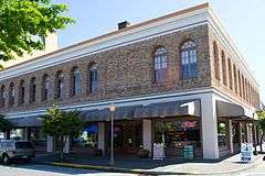
The Marshfield District of Coos Bay is the historic central downtown and business district of the city. Old Marshfield and its surrounding neighborhoods were what comprised the original Coos Bay before the annexations of Empire and Eastside during the 20th century. The Marshfield District contains many buildings listed on the National Register of Historic Places, such as the Carnegie Library, Chandler Hotel, Egyptian Theatre and Tioga Hotel.[21] The waterfront area of the Marshfield District has a boardwalk with a city dock, bicycling trail and pavilions featuring historical and interpretive displays.[22]
The Milner Crest district is a residential neighborhood developed in the mid-20th century, located at the crest of a hill overlooking the bay, north of Mingus Park and the Marshfield District. The majority of the Coos Bay area's medical facilities are located in this district.[23]
The Eastside district of Coos Bay was originally called East Marshfield for its situation on the east side of the bay. East Marshfield post office was established in 1891, and it operated intermittently until 1908, when the name was changed to Eastside. The community of Eastside merged with the city of Coos Bay in 1983.[24] Eastside is primarily a residential neighborhood and is home to Millicoma Middle School, walking trails at Millicoma Marsh[25] and a public boat launch.[26]
The Empire district (Coos language: Hanisich[6]) was founded as Empire City in 1853 by members of the Coos Bay Company from Jacksonville, Oregon, and at the time it was assumed that the area would be center of the region. The company was formed after the discovery of gold in northern California and southwestern Oregon. For a time Empire City was the county seat of Coos County. The first post office in the location was called Elkhorn, which ran from 1853 until 1854. It was the first post office in what is now Coos County, though at the time it was part of Umpqua County. Empire City post office was established in 1858 and ran until 1894, when it was renamed Empire. In 1965, the city of Empire voted to consolidate with Coos Bay.[24] Today, Empire is the location of Madison Elementary School, Sunset Intermediate School and a business district along Cape Arago Highway.[27][28]
Climate
This region experiences warm (but not hot) and dry summers, with no average monthly temperatures above 71.6 °F (22.0 °C) which means more mild weather usually in the lower 40s to upper 60s. According to the Köppen Climate Classification system, Coos Bay has a warm-summer Mediterranean climate, abbreviated "Csb" on climate maps.[29] The record high temperature of 102 °F was recorded on September 22, 2009,[30] and the record low of 0 °F was recorded December 19, 1990.
| Climate data for Coos Bay, Oregon | |||||||||||||
|---|---|---|---|---|---|---|---|---|---|---|---|---|---|
| Month | Jan | Feb | Mar | Apr | May | Jun | Jul | Aug | Sep | Oct | Nov | Dec | Year |
| Record high °F (°C) | 74 (23) |
82 (28) |
88 (31) |
88 (31) |
94 (34) |
92 (33) |
96 (36) |
91 (33) |
96 (36) |
95 (35) |
76 (24) |
70 (21) |
96 (36) |
| Average high °F (°C) | 53 (12) |
55 (13) |
55 (13) |
57 (14) |
61 (16) |
64 (18) |
67 (19) |
68 (20) |
68 (20) |
63 (17) |
57 (14) |
53 (12) |
60 (16) |
| Average low °F (°C) | 39 (4) |
41 (5) |
41 (5) |
43 (6) |
47 (8) |
50 (10) |
53 (12) |
53 (12) |
50 (10) |
46 (8) |
43 (6) |
39 (4) |
45 (7) |
| Record low °F (°C) | 17 (−8) |
14 (−10) |
27 (−3) |
28 (−2) |
33 (1) |
22 (−6) |
39 (4) |
34 (1) |
34 (1) |
28 (−2) |
20 (−7) |
0 (−18) |
0 (−18) |
| Average precipitation inches (mm) | 9.54 (242.3) |
8.12 (206.2) |
7.94 (201.7) |
5.19 (131.8) |
3.40 (86.4) |
1.72 (43.7) |
0.51 (13) |
0.88 (22.4) |
1.73 (43.9) |
4.62 (117.3) |
10.36 (263.1) |
10.42 (264.7) |
64.43 (1,636.5) |
| Average snowfall inches (cm) | 0.20 (0.51) |
0.20 (0.51) |
0.10 (0.25) |
0 (0) |
0 (0) |
0 (0) |
0 (0) |
0 (0) |
0 (0) |
0 (0) |
0.10 (0.25) |
0.20 (0.51) |
0.80 (2.03) |
| Source: http://www.intellicast.com/Local/History.aspx?location=USOR0072 | |||||||||||||
Demographics
| Historical population | |||
|---|---|---|---|
| Census | Pop. | %± | |
| 1870 | 250 | — | |
| 1880 | 642 | 156.8% | |
| 1890 | 1,461 | 127.6% | |
| 1900 | 1,391 | −4.8% | |
| 1910 | 2,930 | 110.6% | |
| 1920 | 4,034 | 37.7% | |
| 1930 | 5,287 | 31.1% | |
| 1940 | 5,259 | −0.5% | |
| 1950 | 6,223 | 18.3% | |
| 1960 | 7,084 | 13.8% | |
| 1970 | 13,466 | 90.1% | |
| 1980 | 14,424 | 7.1% | |
| 1990 | 15,076 | 4.5% | |
| 2000 | 15,374 | 2.0% | |
| 2010 | 15,967 | 3.9% | |
| Est. 2015 | 16,182 | [31] | 1.3% |
| source:[32][33] | |||
2010 census
As of the census of 2010, there were 15,967 people, 6,950 households, and 3,991 families residing in the city. The population density is 1,451.9 people per square mile (560.5/km²). There are 7,542 housing units at an average density of 669.9 per square mile (258.6/km²). The racial makeup of the city is 87.1% White, 0.6% African American, 2.6% Native American, 1.4% Asian, 0.3% Pacific Islander, 2.8% from other races, and 5.2% from two or more races. 4.49% of the population are Hispanic or Latino of any race.[3]
There are 6,950 households of which 25.9% have children under the age of 18 living with them, 40.2% are married couples living together, 12.1% had a female householder with no husband present, and 42.6% are non-families. The percentage of male householders with no wife present is 5.1%. 33.6% of all households are made up of individuals and 14.8% have someone living alone who is 65 years of age or older. The average household size is 2.27 and the average family size is 2.82.[3]
In the city the population dispersal was 20.3% under the age of 18, 7.1% from 15 to 19, 19.2% from 25 to 44, 27.3% from 45 to 64, and 19.1% who are 65 years of age or older. The median age is 41.6 years. The median income for a household in the city is $37,985, and the median income for a family is $47,998. Males have a median income of $41,069 versus $26,648 for females. The per capita income for the city is $21,481. 18.1% of the population and 11.6% of families are below the poverty line. Out of the total population, 21.6% of those under the age of 18 and 7.9% of those 65 and older are living below the poverty line.[3]
2000 census
As of the census of 2000, there were 15,374 people, 6,497 households, and 4,028 families residing in the city. The population density is 1,451.9 people per square mile (560.5/km²). There are 7,094 housing units at an average density of 669.9 per square mile (258.6/km²). The racial makeup of the city is 90.75% White, 0.37% African American, 2.27% Native American, 1.44% Asian, 0.31% Pacific Islander, 1.35% from other races, and 3.51% from two or more races. 4.49% of the population are Hispanic or Latino of any race.[3]
There are 6,497 households out of which 27.1% have children under the age of 18 living with them, 46.3% are married couples living together, 11.6% had a female householder with no husband present, and 38.0% are non-families. The percentage of male householders with no wife present is unknown. 30.7% of all households are made up of individuals and 12.9% have someone living alone who is 65 years of age or older. The average household size is 2.29 and the average family size is 2.83.[3]
In the city the population dispersal was 22.6% under the age of 18, 9.2% from 18 to 24, 25.2% from 25 to 44, 23.8% from 45 to 64, and 19.2% who are 65 years of age or older. The median age is 40 years. For every 100 females there are 94.4 males. For every 100 females age 18 and over, there are 90.8 males. The median income for a household in the city is $31,212, and the median income for a family is $38,721. Males have a median income of $32,324 versus $22,192 for females. The per capita income for the city is $18,158. 16.5% of the population and 12.7% of families are below the poverty line. Out of the total population, 21.0% of those under the age of 18 and 9.9% of those 65 and older are living below the poverty line.[3]
Arts and culture
Museums and other attractions
_(cooDA0010).jpg)
- Coos Art Museum, a museum in Downtown Coos Bay, has operated since 1950. Located in a historic former US Post Office, it offers tour exhibits, art classes, lectures, and community events. The museum holds 477 permanent collections and rotates its displays throughout the year.
- Coos Historical & Maritime Center is a proposed 11,000-square-foot (1,000 m2) museum to be built on a 3-acre (1.2 ha) site on Coos Bay's historic waterfront. The museum is expected to open in Spring 2015.[34]
- Coos Bay Iron Works, a producer of logging equipment, opened in 1882 and is still in business on Front Street, using a variety of antique tools dating to the Industrial Revolution.[35]
- The Egyptian Theatre was part of a popular architectural movement and is the only Oregon movie house that still has its original theatre organ installation. Built in 1925, the theatre was closed in 2005, but it was reopened shortly after by a nonprofit agency. Closed again in 2011, the Egyptian Theater Preservation Association and the Coos Bay Urban Renewal Agency are raising money to correct several structural issues that will allow the theater to reopen in early 2014.
- Oregon Coast Music Festival is an annual festival held the last two weeks of July, founded in 1978. Local, national and International artists perform diverse genres such as Native American, Celtic, Jazz and Chamber as well as an 80 piece orchestra.[36]
- Blackberry Arts Festival is an annual festival that began in 1982, held in August, that showcases local arts, crafts, food and entertainment in the historic Marshfield District.[37]
Parks and recreation
_(cooDA0031).jpg)

Mingus Park, near downtown Coos Bay, features a 1-mile (1.6 km)[38] walking path that encircles a large pond with a resident population of duck and geese. An outdoor swimming pool is available during the summer months, as well as an outdoor amphitheater. An 18-hole disc golf course is in the forest on the north side of the park. A skatepark and tennis courts are in the southeast portion. In addition, there are playgrounds for children in the southwest, and a softball field in the east.
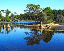
John Topits Park, in the northwestern section of Coos Bay, is a 120-acre (49 ha) natural area encompassing the Empire Lakes and protected coastal dune and forest land. No motor boats are permitted on the lakes. However, there is a launch for canoes, kayaks and other non-motorized boats. There are 5.5 miles (8.9 km) of pedestrian and cycling trails. The Empire Lakes are home to a variety of fish (bass, blugill, perch, catfish), waterfowl and birds.[39]
The greater Coos Bay area has a variety of outdoor recreation opportunities, including the Oregon Dunes National Recreation Area, which brings approximately 1.5 million visitors each year.[40] The ocean beaches near Coos Bay are devoid of the level of development seen on other areas of the Oregon Coast, due to much of the coastline being designated state and county parks. Across the entrance bar to Coos Bay from the Oregon Dunes National Recreation Area lie the rugged cliffs and pocket beaches of Bastendorf Beach County Park, Yoakam Point State Park, Sunset Bay State Park, Shore Acres State Park and Cape Arago State Park. Approximately 11 miles (18 km) southwest of Coos Bay is the South Slough National Estuarine Research Reserve and approximately 25 miles (40 km) east in the Coast Range is Golden and Silver Falls State Natural Area.


Government
The City of Coos Bay operates under a council-manager form of government. The Coos Bay City Council is composed of a mayor and six councilors who are elected citywide to serve four-year terms. The council is responsible for setting policy decisions and they in turn hire a city manager to oversee the day-to-day administrative functions of the city. Coos Bay operates its own library, fire department, public works and police department. The fire department has two fire stations that are staffed 24 hours a day. There is a third station that is used to house additional apparatus.
The federally recognized Confederated Tribes of Coos, Lower Umpqua and Siuslaw Indians are headquartered in Coos Bay.[41]
Politics
Coos Bay is historically a Democratic stronghold. Every precinct within the city voted for Democrat Barack Obama in the 2008 and 2012 presidential elections.[42][43]
Coos Bay is represented in the United States House by Peter Defazio (D-Springfield) and in the Oregon Legislature by State Senator Arnie Roblan (D-Coos Bay) and State Representative Caddy McKeown (D-Coos Bay).
Education

- Public education
Coos Bay K–12 public education is served by the Coos Bay School District.
- Higher education
Southwestern Oregon Community College (or SWOCC) offers certificates and associate degrees, and has a dual admissions programs in partnership with Oregon public universities.
Oregon Institute of Marine Biology (or OIMB) is the marine station of the University of Oregon. It is in Charleston, at the mouth of Coos Bay. This 100-acre (0.40 km2) marine station was first deeded to the University of Oregon in 1931.
Health care
Coos Bay has the largest concentration of health care facilities on the Oregon Coast and serves as a regional hub for the Central and Southern Coasts, as well as inland areas.[23] Bay Area Hospital, the largest hospital on the coast has 172 beds and is undergoing a 97,000-square-foot (9,000 m2) expansion.[44] Other facilities in the city include North Bend Medical Center, Oregon Coast Spine Institute, Bay Clinic, South Coast Center for Cosmetic Surgery, South Coast Orthopedic Associates and Southwest Physical Therapy.[23]
Renewable energy
Ocean Power Technologies, a renewable energy company, based in Pennington, New Jersey, is proposing to develop a utility-scale, commercial wave park in North America at Coos Bay. The planned size of this park is up to 100 megawatts, and it will be the largest wave energy project in the world when it is completed.[45]
Transportation
Coos Bay is located along U.S. Highway 101.
- Air
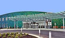
The Southwest Oregon Regional Airport (ICAO: KOTH, IATA: OTH) is a public airport located in adjacent North Bend and is the 5th busiest airport in Oregon, as well as the largest airport on the Oregon Coast. Currently (2014) the airport hosts general aviation and charter services, as well as offering daily commercial flights to/from both San Francisco and Portland.[46]
- Intercity Bus
Porter Stage Lines provides bus service from Coos Bay with several stops, including Eugene, which has connections with Amtrak rail services and the Greyhound bus network. Porter Stage Lines then extends to Bend and ends at Ontario in eastern Oregon, and then reverses the trip.
- Intracity Bus
Coos County Area Transit or CCAT provides daily loop service to 54 stops around Coos Bay and North Bend.[47]
- Port and rail
The Port of Coos Bay provides freight shipping services. The Central Oregon and Pacific Railroad operated the Coos Bay Rail Link linking the port to the national rail network. The line is now operated by Coos Bay Rail Link.
Media
- Radio
- Television
- Newspaper
Notable people
- Sheila Bleck - IFBB professional bodybuilder
- Mel Counts, professional basketball player, 1964 Olympic gold medalist
- Claire Falkenstein, sculptor renowned for large scale abstract metal and glass public sculptures
- Buddy Hayes, musician from Lawrence Welk
- Mark Helfrich, University of Oregon Football Head Coach from 2013-2016
- Princess Irina of Romania, daughter of King Michael of Romania
- Armin D. Lehmann, survivor of last days of Nazi Germany in Hitler's Bunker
- Steve Neal, historian and journalist
- Steve Prefontaine, Olympic distance runner; born in Coos Bay and attended Marshfield High School
- George Whitty, three time Grammy Award winning musician, brother of playwright, Jeff Whitty
- Jeff Whitty, Tony Award winning playwright
Sister city
Coos Bay has one sister city:[48]
See also
References
- ↑ "Joe Benetti". KCBY 11. Retrieved 27 November 2016.
- 1 2 "US Gazetteer files 2010". United States Census Bureau. Archived from the original on 2012-07-14. Retrieved 2012-12-21.
- 1 2 3 4 5 6 7 8 "American FactFinder". United States Census Bureau. Retrieved 2012-12-21.
- ↑ "Population Estimates". United States Census Bureau. Archived from the original on 2013-06-17. Retrieved 2013-06-02.
- ↑ "US Board on Geographic Names". United States Geological Survey. 2007-10-25. Retrieved 2008-01-31.
- 1 2 "Hanis for Beginners" (PDF). Confederated Tribes of Coos, Lower Umpqua and Siuslaw Indians. 2001. Retrieved April 6, 2014.
- ↑ Coos Bay
- ↑ City of Coos Bay, OREGON :: coosbayonline.com ::
- 1 2 3 4 5 6 7 8 "Bay Area History". Oregon Bay Area Chamber of Commerce. Accessed September 2010.
- ↑ Samuel Bawlf (2003). The Secret Voyage of Sir Francis Drake: 1577-1580. New York: Walker & Company; 1st Edition (May 1, 2003). p. 363. ISBN 0-8027-1405-6.
- 1 2 "History of Coos Bay". City of Coos Bay. Accessed September 2010.
- ↑ Wells, Gwen. "Contact and Settlement: Settlement Begins". The Oregon History Project. Oregon Historical Society. Retrieved April 15, 2012.
- ↑ Dodge, Orvil (1898). Pioneer History of Coos and Curry Counties, Oregon. Salem, Oregon: Capital Printing Company. pp. 115–125.
- ↑ "Our History". Coos Bay United Methodist Church. Retrieved 2014-04-06.
- ↑ Oregon Masons
- ↑ McLagan, Elizabeth. A Peculiar Paradise: A History of Blacks in Oregon.
- ↑ Honore, Chris (June 22, 2005). "Oregon's dark hour". Ashland Daily Tidings.
- ↑ "Historic Walking Tour of Coos Bay". Oregon's Adventure Coast.
- ↑ 11-25-2002. "Roof Collapse Takes Three Oregon Firefighters". Northwest NewsChannel 8 (report). Accessed September 2010.
- ↑ "Coos Bay Topographic Map". Trails.com. Retrieved 17 October 2012.
- ↑ "Historic Building Preservation Information" (PDF). City of Coos Bay. Retrieved 17 October 2012.
- ↑ "Coos Bay- About the Harbor" (PDF). Oregon.gov.
- 1 2 3 "Medical Facilities". Oregon Bay Area Chamber of Commerece. Retrieved 17 October 2012.
- 1 2 McArthur, Lewis A.; Lewis L. McArthur (2003) [1928]. Oregon Geographic Names (Seventh ed.). Portland, Oregon: Oregon Historical Society Press. ISBN 0-87595-277-1.
- ↑ "Millicoma Marsh". Coos Trails. Retrieved 17 October 2012.
- ↑ "Marine Board Approves Grant for City of Coos Bay". Oregon State Marine Board. Retrieved 17 October 2012.
- ↑ "Assessment & Recommended Actions for the Empire District" (PDF). City of Coos Bay. Retrieved 17 October 2012.
- ↑ "American Fact Finder". United States Census Bureau. Retrieved 17 October 2012.
- ↑ Climate Summary for Coos Bay, Oregon
- ↑ http://m.theworldlink.com/news/local/heat-wave-hits-coast/article_cdc31ae7-2acb-5c1a-b586-d4568a417e11.html?mobile_touch=true
- ↑ "Annual Estimates of the Resident Population for Incorporated Places: April 1, 2010 to July 1, 2015". Retrieved July 2, 2016.
- ↑ Moffatt, Riley. Population History of Western U.S. Cities & Towns, 1850-1990. Lanham: Scarecrow, 1996, 208.
- ↑ "Subcounty population estimates: Oregon 2000-2007" (CSV). United States Census Bureau, Population Division. 2009-03-18. Retrieved 2009-05-09.
- ↑ "New History Museum Details". Coos Historical & Maritime Museum. Retrieved 19 October 2014.
- ↑ Coos Bay Iron Works
- ↑ "About OCMA". Oregon Coast Music Association.
- ↑ "Blackberry Arts Festival". Coos Bay Downtown Association. Retrieved 17 October 2012.
- ↑ Mingus Park
- ↑ "Empire Lakes (John Topits Park)". Coostrails.com. Retrieved 17 October 2012.
- ↑ Siuslaw National Forest
- ↑ "Tribal Directory." National Congress of American Indians. Retrieved 8 Sept 2013.
- ↑ "Final Official Totals Report" (PDF). Coos County Elections Office. Retrieved 17 October 2012.
- ↑ "Oregon Voter Registration By County". Northwest News Network.
- ↑ "About Us: History". Bay Area Hospital. Retrieved 17 October 2012.
- ↑ Wave power planned for Coos Bay
- ↑ "FlyOTH, Southwest Oregon Regional Airport". Retrieved 18 February 2014.
- ↑ "Transit Schedule". Coos County Area Transit. Retrieved 27 November 2016.
- ↑ State of Oregon Economic & Community Development Department: Oregon Sister Relationships Archived March 13, 2005, at the Wayback Machine.
External links
| Wikivoyage has a travel guide for Coos Bay. |
| Wikimedia Commons has media related to Coos Bay, Oregon. |
- Entry for Coos Bay in the Oregon Blue Book
- "Coos Bay". The Oregon Encyclopedia.
- The Coos Bay-North Bend Visitor & Convention Bureau
Municipalities and communities of Coos County, Oregon, United States | ||
|---|---|---|
| Cities |  | |
| CDPs | ||
| Unincorporated communities | ||
| Ghost town | ||