Elugelab

Elugelab (or Elugelap; Marshallese: Āllokļap, [æ̯ælʲlʲe͡oɡʷ(ɔ͡ʌ)ɫɑ͡æpʲ][1]) was an island, part of the Enewetak atoll in the Marshall Islands. It was increased in size,[2] and then destroyed by the world's first true hydrogen bomb test on 1 November 1952, a test which was codenamed shot "Mike" of Operation Ivy. Prior to being enlarged, and destroyed, the island was described as "just another small naked island of the atoll".[3]
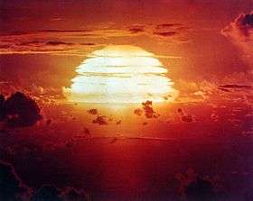
The fireball created by Ivy Mike had a maximum radius of 2.9 to 3.28 km (1.80 to 2.04 mi).[4][5][6] This maximum is reached a number of seconds after the detonation and during this time the hot fireball invariably rises due to buoyancy. While still relatively close to the ground, the fireball had yet to reach its maximum dimensions and was thus approximately "three and one quarter" miles (5.2 km) wide.[7]
The detonation produced a crater 6,240 feet (1.90 km) in diameter and 164 feet (50 m) deep where Elugelab had once been;[8] the blast and water waves from the explosion (some waves up to twenty feet high) stripped the test islands clean of vegetation, as observed by a helicopter survey within 60 minutes after the test, by which time the mushroom cloud had blown away. The island "became dust and ash, pulled upward to form a mushroom cloud that rose about twenty-seven miles into the sky. According to Eric Schlosser, all that remained of Elugelab was a circular crater filled with seawater, more than a mile in diameter and "fifteen stories deep".[9] The blast yielded 10.4 megatons of explosive energy, 700 times the energy that leveled central Hiroshima.[10]
Aerial footage of Elugelab and adjacent islands well before Mike shot at a time prior to the connecting causeway being created is available,[11] as is footage after the causeway was finished that supported the diagnostic Krause-Ogle box light pipe system,[12] with numerous trees removed in preparation of the shot also plainly evident,[13] along with footage of the aforementioned helicopter survey of the Mike crater soon after the detonation,[14] and finally, high altitude footage of the crater accompanied with details of its depth - "175 feet deep" - equivalent to the height of a "17 storey building" and with an area large enough to accommodate about "14 pentagon buildings".[15]
The detonation also collapsed some natural crevices in the reef, some distance away from the rim of the crater.[16]
Full radioecology recovery surveys were documented before and after each test series. For a brief online introduction into some of these studies - with specific reference to the ecological effects of the 1.69 megatons Operation Castle Nectar shot, detonated in 1954 on a barge just north east of the crater of the 10.4 megatons Ivy Mike thermonuclear test - see a report by the University of Washington's Laboratory of Radiation Biology and .
Gallery
-
Ivy Mike test of 1952, this video contains a misleading post production explosion sound overdubbed on what was a completely silent detonation from the vantage point of the camera, with the sound of the blast wave only arriving a number of seconds later, akin to thunder, with the exact time, depending on its distance.
-
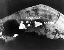
The 1954 test shot Nectar of Operation Castle produced a yield of 1.69 megatons and was detonated just North East of Ivy Mike's Elugelab crater, off the coast of Teiter (Gene) Island. The Island of Bogon/Bokon (Irene), is the spear head shaped object at the bottom right of the screen. The maximum average nuclear fireball radius is approximately 1.4 to 1.6 km (0.87 to 0.99 mi).[1][2]
-
Test shot Seminole of Operation Redwing, yield 13.7 kiloton, conducted on the coast of the island of Bogon/Bokon (Irene) on June 6, 1956.
-
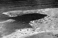
Redwing Seminole crater on Bogon/Bokon (Irene) island.
-
Test shot Apache of Operation Redwing, yield 1.85 megaton,[3] detonated in a barge on July 8, 1956, at "Elugelab (Flora)" 11°39′52″N 162°11′40″E / 11.66451°N 162.19446°E or off the coast of what remained of Teiter Island after the detonation of test shot Nectar of Operation Castle.
-

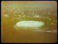
A 2002 True color photograph of Enewetak Atoll, the relatively large Ivy Mike crater can be seen at the top of the atoll in this image with the smaller, adjoining Castle Nectar crater, in close proximity. The much smaller Redwing Seminole crater can faintly be seen on Bogon Island.
-

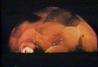
A single high quality frame from test shot Seminole of Operation Redwing

- ^ Walker, John (June 2005). "Nuclear Bomb Effects Computer". Fourmilab. Retrieved 2009-11-22.
- ^ Walker, John (June 2005). "Nuclear Bomb Effects Computer Revised Edition 1962, Based on Data from The Effects of Nuclear Weapons, Revised Edition "The maximum fireball radius presented on the computer is an average between that for air and surface bursts. Thus, the fireball radius for a surface burst is 13 percent larger than that indicated and for an air burst, 13 percent smaller. "". Fourmilab. Retrieved 2009-11-22.
- ^ "DTRA Operation REDWING Fact Sheet" (PDF).
See also
- Nuclear fusion
- Ivy Mike
- Operation Ivy
- Operation Castle
- Operation Redwing
- Nuclear fission
- Barringer crater a deeper crater that formed in a natural impact event with the release of about the same amount of energy - 10 megatons.
- Krakatoa - a larger island that was destroyed by a much more powerful natural volcanic explosion.
- Explosion crater
References
Coordinates: 11°40′0″N 162°11′13″E / 11.66667°N 162.18694°E
- ↑ Marshallese-English Dictionary - Place Name Index
- ↑ "Operation Ivy (1952), see 24:00".
- ↑ "Operation Ivy (1952), see 24:00".
- ↑ Walker, John (June 2005). "Nuclear Bomb Effects Computer". Fourmilab. Retrieved 2009-11-22.
- ↑ Walker, John (June 2005). "Nuclear Bomb Effects Computer Revised Edition 1962, Based on Data from The Effects of Nuclear Weapons, Revised Edition 'he maximum fireball radius presented on the computer is an average between that for air and surface bursts. Thus, the fireball radius for a surface burst is 13 percent larger than that indicated and for an air burst, 13 percent smaller'". Fourmilab. Retrieved 2009-11-22.
- ↑ "Mock up". Remm.nlm.gov. Retrieved 2013-11-30.
- ↑ "Operation Ivy (1952), see 56:50".
- ↑ Nuclear Weapon Archive
- ↑ Schlosser, Eric (2013). Command and Control: Nuclear Weapons, the Damascus Accident, and the Illusion of Safety. Penguin Press. ISBN 978-1-59420-227-8.
- ↑ "Soviets Stole Bomb Idea From U.S., Book Says". The New York Times. 30 December 2008. Retrieved 2008-12-29.
|first1=missing|last1=in Authors list (help) - ↑ "Operation Ivy (1952), see 23:00".
- ↑ "Operation Ivy 1952 - Enewetak Atoll, Marshall Islands "The 9000 foot long causeway linking the islands together is the "Krause-Ogle box", a 9 foot square aluminum-sheathed plywood tunnel filled with helium ballonets. This box allowed gamma and neutron radiation from the blast to travel with little absorption to test instruments on Bogon."".
- ↑ "Operation Ivy (1952), see 30:00".
- ↑ "Operation Ivy (1952), see 47:00".
- ↑ "Operation Ivy (1952), see 58:30".
- ↑ "Operation Ivy (1952), see 58:50 note the black lines drawn on the picture that appear momentarily at 58:55".
External links
- "Mike" Test from PBS