Eltz Manor
| Eltz Manor | |
|---|---|
| Dvorac Eltz | |
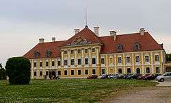 Eltz Manor after renovation (2012) | |
| General information | |
| Architectural style | Baroque |
| Location | Vukovar, Croatia |
| Address |
Županijska 2 32000 Vukovar |
| Current tenants | City Museum Vukovar |
| Construction started | 1749 |
| Completed | 1751 |
| Renovated | 2008–11 |
Eltz Manor (Croatian: Dvorac Eltz, German: Schloss Eltz) is a Baroque castle in Vukovar, Croatia. The 18th century manor is the location of the Vukovar City Museum. The manor, as it previously appeared, is depicted on the reverse of the Croatian 20 kuna banknote, issued in 1993 and 2001.[1] After four years of restorations, it was completely restored to its pre-war appearance in October 2011.[2]
History
In 1736 Philipp Karl von Eltz-Kempenich (1665–1743), the Archchancellor of the Holy Roman Empire and Prince-Archbishop of Mainz, had purchased Vukovar manor in the eastern Kingdom of Slavonia (Syrmia), then part of the Habsburg Monarchy ruled by Emperor Charles VI. The castle was originally built between the period of 1749 to 1751 by the Archchancellor's descendants of the German Catholic noble House of Eltz and was gradually extended over time. The estates near the Military Frontier were however exposed to raids by Ottoman troops but also by local Hajduk paramilitary forces.
After the Yugoslav Partisans had gained control over the country in late World War II, the manor was confiscated by the communist administration of Yugoslavia in 1944, and the family of Jakob Graf zu Eltz was forced to leave Vukovar. In 1990, he returned from Eltville to the newly established state of Croatia and became a member of the Sabor parliament at Zagreb. Eltz Manor, however, suffered a great deal of damage during the Croatian War of Independence, when it was bombarded by the Yugoslav People's Army during the Battle of Vukovar.
Gallery
-

Parts of the manor were nearly destroyed
-

Much of the roof was missing after the war
-

Damaged tower and destroyed building
-
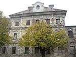
Damaged main facade
-

Statues of angels in a heraldic setting, with ruins in the background
References
- ↑ Croatian National Bank. Features of Kuna Banknotes: 20 kuna (1993 issue) & 20 kuna (2001 issue). – Retrieved on 30 March 2009.
- ↑ "Obnovljeni dvorac Eltz vraća stare vizure Vukovara". Glas Slavonije (in Croatian). 2011-10-29. Retrieved 2011-10-30.
External links
Coordinates: 45°21′27″N 18°59′42″E / 45.3575358481°N 18.9949858189°E
| History |  | |
|---|---|---|
| Districts |
| |
| Buildings and landmarks |
| |
| Places of worship |
| |
| Culture |
| |
| Education | ||
| Transport |
| |
| Manifestations |
| |