Elizabethtown, Ohio
| Elizabethtown, Ohio | |
|---|---|
| Census-designated place | |
 Location in Hamilton County and the state of Ohio. | |
| Coordinates: 39°9′30″N 84°48′16″W / 39.15833°N 84.80444°WCoordinates: 39°9′30″N 84°48′16″W / 39.15833°N 84.80444°W | |
| Country | United States |
| State | Ohio |
| County | Hamilton |
| Area | |
| • Total | 0.9 sq mi (2.3 km2) |
| • Land | 0.9 sq mi (2.3 km2) |
| • Water | 0 sq mi (0 km2) |
| Elevation[1] | 491 ft (150 m) |
| Population (2010) | |
| • Total | 350 |
| • Density | 390/sq mi (150/km2) |
| Time zone | Eastern (EST) (UTC-5) |
| • Summer (DST) | EDT (UTC-4) |
| FIPS code | 39-24850[2] |
| GNIS feature ID | 1056275[1] |
Elizabethtown is a census-designated place (CDP) in Whitewater Township, Hamilton County, Ohio, United States. The population was 350 at the 2010 census.[3]
History
Elizabethtown was platted in 1817 by Isaac Mills, and named for his wife. It was a depot on the Cleveland, Cincinnati, Chicago and St. Louis Railway. In 1894, Elizabethtown was described as having three stores, two churches and a grain elevator.[4]
Geography
Elizabethtown is located at 39°9′30″N 84°48′16″W / 39.15833°N 84.80444°W,[5] in the valley of the Great Miami River, 20 miles (32 km) west of downtown Cincinnati. U.S. Route 50 runs through the center of the community, and Interstate 275 passes it to the northwest but does not provide direct access to it.
According to the United States Census Bureau, the CDP has a total area of 0.89 square miles (2.3 km2), all land.[3]
References
- 1 2 "US Board on Geographic Names". United States Geological Survey. 2007-10-25. Retrieved 2008-01-31.
- ↑ "American FactFinder". United States Census Bureau. Retrieved 2008-01-31.
- 1 2 "Geographic Identifiers: 2010 Demographic Profile Data (G001): Elizabethtown CDP, Ohio". U.S. Census Bureau, American Factfinder. Retrieved November 13, 2012.
- ↑ Nelson, S. B. (1894). History of Cincinnati and Hamilton County, Ohio: Their Past and Present, Including...biographies and Portraits of Pioneers and Representative Citizens, etc., Volume 1. p. 461. Retrieved 11 December 2013.
- ↑ "US Gazetteer files: 2010, 2000, and 1990". United States Census Bureau. 2011-02-12. Retrieved 2011-04-23.
Municipalities and communities of Hamilton County, Ohio, United States | ||
|---|---|---|
| Cities | 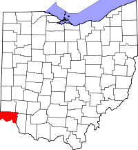 | |
| Villages | ||
| Townships | ||
| CDPs |
| |
| Other unincorporated communities | ||
| Footnotes | ‡This populated place also has portions in an adjacent county or counties | |