El Yunque (Cuba)
For other uses, see El Yunque (disambiguation).
| El Yunque | |
|---|---|
.jpg) El Yunque overseeing the Bay of Baracoa | |
| Highest point | |
| Elevation | 575 m (1,886 ft) [1] |
| Coordinates | 20°21′08″N 74°34′26″W / 20.35222°N 74.57389°WCoordinates: 20°21′08″N 74°34′26″W / 20.35222°N 74.57389°W |
| Naming | |
| Translation | The anvil ((Spanish)) |
| Geography | |
| Location | Cuba |
| Parent range |
Sierra del Purial (Nipe-Sagua-Baracoa) |
| Geology | |
| Mountain type | Table mountain |
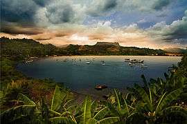
the Bay of Baracoa and El Yunque
El Yunque is a 575-metre-high (1,886 ft) mountain located 7 km (4.3 mi) west of Baracoa and the Baracoa Bay in Cuba's Guantanamo Province. It has a table mountain shape that resembles an anvil ("yunque" in Spanish).
Overview
El Yunque was mentioned by Christopher Columbus in his chronicles about the discovery of the Americas.[2] The Yunque is situated between the banks of the rivers Duaba and Toa, it is 1,125 m (3,691 ft) long and has a total area of 461,000 m2 (4,960,000 sq ft).
El Yunque was declared a National Monument by the Cuban National Commission of Monuments on December 25, 1979.[1]
Gallery
 View from El Yunque
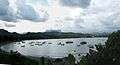 El Yunque from Baracoa bay
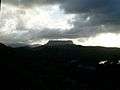 El Yunque in 2006
 View to the west from the foot of El Yunque
References
- 1 2 Baracoa.org. "El Yunque". Retrieved 2006-09-29.
- ↑ Columbus Monuments Pages. "Baracoa". Retrieved 2007-09-29.
External links
![]() Media related to El Yunque at Wikimedia Commons
Media related to El Yunque at Wikimedia Commons
This article is issued from Wikipedia - version of the 4/29/2016. The text is available under the Creative Commons Attribution/Share Alike but additional terms may apply for the media files.