El Jorullo
| El Jorullo | |
|---|---|
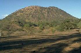 El Jorullo cinder cone | |
| Highest point | |
| Elevation | 1,330 m (4,360 ft) [1] |
| Coordinates | 18°58′24″N 101°42′57″W / 18.97333°N 101.71583°WCoordinates: 18°58′24″N 101°42′57″W / 18.97333°N 101.71583°W[2] |
| Geography | |
| Location | La Huacana, Michoacán, Mexico |
| Geology | |
| Mountain type | cinder cone |
| Last eruption | 1759–1774 |
| Climbing | |
| Easiest route | Hike |
El Jorullo is a cinder cone volcano in Michoacán, central Mexico, on the southwest slope of the central plateau, 33 miles (53 kilometers) southeast of Uruapan in an area known as the Michoacán-Guanajuato volcanic field. It is about 6 miles (10 km) east-northeast of La Huacana. Its current elevation is 4,360 ft (1,329 m). El Jorullo has four smaller cinder cones which have grown from its flanks. The vents of El Jorullo are aligned in a northeast to southwest direction. Lava from these vents cover nine square km around the volcano. Later eruptions produced lavas that had higher silica contents making them thicker than the earlier basalts and basaltic andesite lavas. El Jorullo's crater is about 1,300 by 1,640 feet (400 by 500 m) wide and 490 feet (150 m) deep.
El Jorullo is one of two known volcanoes to have developed in Mexico in recent history. The second, born about 183 years later, was named Parícutin after a nearby village that it eventually destroyed. Parícutin is about 50 miles (80 km) northwest of El Jorullo.
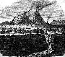
El Jorullo was first erupted on 29 September 1759. Earthquakes occurred prior to this first day of eruption. Once the volcano started erupting, it continued for 15 years...eventually ending in 1774. El Jorullo didn’t develop on a corn field like Parícutin did, but it did destroy what had been a rich agricultural area. It grew approximately 820 feet (250 meters) from the ground in the first six weeks. The eruptions from El Jorullo were primarily phreatic and phreatomagmatic. They covered the area with sticky mud flows, water flows and ash falls. All but the youngest lava flows were covered by this ash fall. Later eruptions from El Jorullo were magmatic with neither mud nor water flows. This 15 year eruption was the longest one El Jorullo has had, and was the longest cinder cone eruption known. Lava flows can still be seen to the north and west of the volcano. The eruption had a VEI of 4.[3]
Parícutin and El Jorullo both rose in an area known for its volcanoes. Called the Trans-Mexican Volcanic Belt, the region stretches about 700 miles (1,120 km) from east to west across southern Mexico. The eruptive activity deposited a layer of volcanic rock some 6,000 feet thick, creating a high and fertile plateau. During summer months, the heights snag moisture-laden breezes from the Pacific Ocean; rich farmland, in turn, has made this belt the most populous region in Mexico. Though the region already boasted three of the country's four largest cities: Mexico City, Puebla, and Guadalajara (the area around Parícutin, some 200 miles west of the capital), it was still a peaceful backwater inhabited by Purépecha in the early 1940s.
See also
References
- ↑ "Michoacán-Guanajuato: Synonyms and Subfeatures". Global Volcanism Program. Smithsonian Institution.
- ↑ "Volcán de Jorullo, Mexico". Peakbagger.com. Retrieved 24 Dec 2014.
- ↑ "Michoacán-Guanajuato: Eruptive History". Global Volcanism Program. Smithsonian Institution.
- "El Jorullo: Credits". Volcano World. Retrieved 16 Apr 2008.
- "Michoacán-Guanajuato". Global Volcanism Program. Smithsonian Institution. Retrieved 16 April 2008.
- "El Jorullo: Credits". Popular Science Monthly. Retrieved 17 Apr 2008.
- "El Jorullo: Credits". Bartleby.com. Retrieved 17 Apr 2008.
External links
| Wikimedia Commons has media related to El Jorullo. |