Al-Fashir
| Al-Fashir الفاشر (Arabic) | |
|---|---|
|
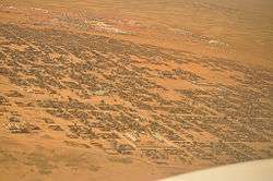
Aerial view of Al-Fashir | |
 Al-Fashir Location in Sudan | |
| Coordinates: 13°37′50″N 25°21′0″E / 13.63056°N 25.35000°ECoordinates: 13°37′50″N 25°21′0″E / 13.63056°N 25.35000°E | |
| Country |
|
| State | North Darfur |
| Population (2012) | |
| • Total | 263,243 |
Al Fashir, Al-Fashir or El Fasher (Arabic: الفاشر) is the capital city of North Darfur, Sudan. It is a large town in the Darfur region of northwestern Sudan, 195 kilometres (121 mi) northeast of Nyala, Sudan. [1] A historical caravan post, Al-Fashir is located at an elevation of about 700 metres (2,300 ft).[1] The town serves as an agricultural marketing point for the cereals and fruits grown in the surrounding region. Al-Fashir is linked by road with both Al-Junaynah and Umm Kaddadah. Al-Fashir had 264,734 residents as of 2006, an increase from 2001, when the population was estimated to be 178,500.[1]
Due to the nearby Abu Shouk[2] and Al Salam[3] IDP camps with the influx of humanitarian aid from the United Nations as a result of the Darfur crisis, the city has experienced a significant economic and population boom. Rents and retail sales increased, including the selling of bottled water and the opening of a pizza parlor to cater to the demand from western aid workers. The number of gas stations has tripled in three years as a result of the increase in the amount of automobiles in the city. Employment opportunities also increased as the United Nations offered jobs to citizens. Economics analyst Adam Ahmed stated that the "people [of Al-Fashir] are beginning to think in a more business-minded way" to make the most of their situation.[4]
Al Fashir University was created in 1990 by decree of President Omar Hassan Ahmed Bashir, and was officially opened in February 1991 in premises west of El Fasher Airport and south of the El Fashir School.[5]
History
Late in the 18th century, Sultan 'Abd al-Rahman al-Rashed of the Darfur moved his itinerant court (fashir) to a site called Rahad Tendelti, which soon took the name Al-Fashir.[6] A town developed around the sultan's palace grounds.[1] It was one of the cities Amelia Earhart visited while attempting to cross the world.[7]
Climate
Classified by Köppen-Geiger system as hot desert climate (BWh).
| Climate data for Al-Fashir | |||||||||||||
|---|---|---|---|---|---|---|---|---|---|---|---|---|---|
| Month | Jan | Feb | Mar | Apr | May | Jun | Jul | Aug | Sep | Oct | Nov | Dec | Year |
| Record high °C (°F) | 37.7 (99.9) |
40.1 (104.2) |
42.2 (108) |
43.0 (109.4) |
43.2 (109.8) |
42.5 (108.5) |
41.7 (107.1) |
39.7 (103.5) |
40.2 (104.4) |
39.8 (103.6) |
38.0 (100.4) |
36.5 (97.7) |
43.2 (109.8) |
| Average high °C (°F) | 29.8 (85.6) |
31.9 (89.4) |
35.6 (96.1) |
37.8 (100) |
38.9 (102) |
38.4 (101.1) |
35.4 (95.7) |
33.9 (93) |
35.7 (96.3) |
36.0 (96.8) |
32.7 (90.9) |
30.0 (86) |
34.7 (94.5) |
| Daily mean °C (°F) | 19.7 (67.5) |
21.7 (71.1) |
25.5 (77.9) |
28.1 (82.6) |
30.1 (86.2) |
30.7 (87.3) |
28.9 (84) |
27.9 (82.2) |
28.5 (83.3) |
27.5 (81.5) |
23.0 (73.4) |
20.1 (68.2) |
26.0 (78.8) |
| Average low °C (°F) | 9.5 (49.1) |
11.4 (52.5) |
15.5 (59.9) |
18.3 (64.9) |
21.3 (70.3) |
23.0 (73.4) |
22.5 (72.5) |
21.8 (71.2) |
21.2 (70.2) |
18.9 (66) |
13.6 (56.5) |
10.3 (50.5) |
17.3 (63.1) |
| Record low °C (°F) | 0.7 (33.3) |
1.4 (34.5) |
6.5 (43.7) |
8.2 (46.8) |
12.8 (55) |
15.7 (60.3) |
15.6 (60.1) |
13.5 (56.3) |
15.5 (59.9) |
7.1 (44.8) |
5.6 (42.1) |
2.0 (35.6) |
0.7 (33.3) |
| Average precipitation mm (inches) | 0.0 (0) |
0.0 (0) |
0.3 (0.012) |
1.9 (0.075) |
7.0 (0.276) |
14.6 (0.575) |
59.1 (2.327) |
87.0 (3.425) |
35.5 (1.398) |
7.1 (0.28) |
0.0 (0) |
0.0 (0) |
212.6 (8.37) |
| Average precipitation days (≥ 0.1 mm) | 0.0 | 0.1 | 0.1 | 0.3 | 1.3 | 2.4 | 8.3 | 9.3 | 4.5 | 1.0 | 0.0 | 0.0 | 27.3 |
| Average relative humidity (%) | 24 | 21 | 18 | 18 | 22 | 33 | 52 | 61 | 46 | 30 | 27 | 26 | 31.5 |
| Mean monthly sunshine hours | 313.1 | 288.4 | 300.7 | 297.0 | 310.0 | 252.0 | 235.6 | 217.0 | 252.0 | 297.6 | 315.0 | 316.2 | 3,394.6 |
| Percent possible sunshine | 89 | 88 | 81 | 80 | 73 | 68 | 59 | 62 | 70 | 82 | 91 | 90 | 78 |
| Source #1: NOAA[8] | |||||||||||||
| Source #2: Climate Charts[9] | |||||||||||||
See also
- Chad – border country near Nyala, Sudan.
- History of Darfur
Notes
- 1 2 3 4 "Al-Fashir" (description), Encyclopædia Britannica, 2007, webpage:
- ↑ Mitchell, Andrea (2007) Talking Back...to Presidents, Dictators, and Assorted Scoundrels (2nd edition) Penguin Books, New York, page xli, ISBN 978-0-14-303873-3
- ↑ "Northern Darfur: Abu Shouk and Al Salam IDP Camps" map, United Nations Office for the Coordination of Humanitarian Affairs (OCHA), Date Created: 1 February 2009
- ↑ Sanders, Edmund. A Darfur capital is a humanitarian boomtown, Los Angeles Times, 2008-04-30.
- ↑ "History of the University". Al Fashir University. Retrieved 15 September 2011.
- ↑ de Waal, Alex (2005). Famine That Kills: Darfur. Cary, NC: Oxford University Press. p. 60.
- ↑ Vizard, Frank (February 1997) "On Earhart's Wings" Popular Science 250(2): pp. 50–52, page 51
- ↑ "El Fasher (Al-Fashir) Climate Normals 1961–1990". National Oceanic and Atmospheric Administration. Retrieved January 17, 2016.
- ↑ "El Fasher, Sudan: Climate, Global Warming, and Daylight Charts and Data". Climate Charts. Retrieved 25 August 2013.