Yekaterinoslav Governorate
| Ekaterinoslav Governorate Екатеринославская губернiя | |||||
| Governorate of Russian Empire, Ukrainian State, Ukrainian Soviet Socialist Republic | |||||
| |||||
|
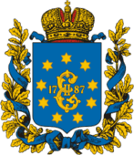
Coat of arms | |||||
 | |||||
| Capital | Ekaterinoslav | ||||
| History | |||||
| • | Established | 27 February 1802 | |||
| • | Disestablished | 1 August 1925 | |||
| Population | |||||
| • | (1897) | 2,113,700 | |||
| Political subdivisions | uezds: 8 (9 1874–85) | ||||
The Ekaterinoslav Governorate; Ekaterinoslav Gubernia[1] (Russian: Екатеринославская губернiя; translit.: Yekaterinoslavskaya guberniya; Ukrainian: Катеринославська губернія) or Government of Ekaterinoslav was a governorate in the Russian Empire. Its capital was the city of Ekaterinoslav. The capital later became Dnipropetrovsk and its territory lies within what is now Ukraine.
Location
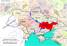
The government was created in 1802 out the Ekaterinoslav Vice-regency. It is located within the former lands of Zaporizhian Sich. The government bordered to the north with the Kharkov Governorate and Poltava Governorate, to the west and southwest with the Kherson Governorate, to the south with the Taurida Governorate and Sea of Azov, and to the east with Don Host Oblast.
Administrative divisions

The governorate was created in place of Novorossiysk Governorate in 1802 and encompassed a huge area of the southern Ukraine. Officially, the new governorate was created as Ekaterinoslav Governorate in 1802 and subdivided into the following uyezds with centres in:
- Ekaterinoslav (Екатеринославъ, Катеринослав) 1802–1923
- Pavlograd (Павлоградъ, Павлоград) 1802–1923
- Bakhmut (Бахмутъ, Бахмут) 1802–1920 transferred to Government of Donetsk
- Novomoskovsk (Новомосковскъ, Новомосковськ) 1802–1923
- Mariupol 1802–1807, 1874–1923 (1807–1874 part of Aleksandrovsk as Greek district)
- Aleksandrovsk (Александровскъ, Олександрівськ) 1805–1920 transferred to Government of Zaporizhia, created from both Mariupol and Pavlohrad
- Slavyanoserbsk (Славяносербскъ, Слав'яносербськ) 1805–1920 created out Bakhmut, transferred to Government of Donetsk
- Verkhnodneprovsk (Верходнѣпровскъ, Верхньодніпровськ) 1805–1923, created out Yekaterinoslav uyezd
- Taganrog 1805–1887, 1918 (1887–1918 part of Don Host Oblast)
- Taganrog city (Таганрог) 1802–1887
- Rostov upon Don city 1802–1887
Changes in Russian Empire
- 1874, the Mariupol (Марiуполь) uyezd was split off the Aleksanrovsk uyezd.
- 1887, Rostov-na-Donu city as well as Taganrog city with its uyezd were transferred back to the Don Host Oblast.
Ukraine
- 1918, Taganrog uyezd was transferred once again, but without the Taganrog city and later again returned to the Don Voisko Province. The Ukrainian People's Republic passed the law for the reformation of the Ukrainian administrative division dividing the governorate into five new lands. The law has failed to be implemented and was canceled due to the nationalist-conservative coup d'état of Pavlo Skoropadsky and establishment of the Ukrainian State. Thus the territory of the governorate was left unchanged and sustained without any major changes until 1919.
South Russia
- 1919 Krivyi Rih uyezd was created partially out of the newly annexed lands of the Kherson Governorate.
Soviet Ukraine
- 1920 Governorate yielded few territories in favor of the newly created Olexandrivsk Governorate and Donetsk Governorate
- 1922 Zaporizhia Governorate was abolished and its territories returned under the subordination of Yekaterinoslav Governorate together with some of Kremenchuk Governorate.
- 1923 All Governorates uyezds were reformed into seven okrugs with two of them (Berdiansk and Oleksandriysk okrugs) liquidated on 3 June 1925.
- On 1 August 1925, the Ekaterinoslav Governorate administration was discontinued.
Okrugs
List of okruhas of Ukraine upon the dissolution of the Governorate:
- Ekaterinoslav
- Zaporizhia
- Kryvyi Rih
- Melitopol
- Pavlohrad
Demographics
The governorate's population, a majority of peasants, was 662,000 in 1811, 902,400 in 1851, 1,204,800 in 1863, and 1,792,800 in 1885. From the second half of the 19th century, with the founding of Yuzovka (Donetsk), the governorate became the coal-mining and metallurgical center of the then Ukraine, incorporating the Dnieper Industrial Region and the Donbass (Donets Basin).
Its population increased to 2,113,674 by 1897. The nationalities within the governorate were: Russians (then divided into archaic categorisation of Little Russian (i.e. Ukrainian) speakers – 68.9% and Great Russian speakers – 17.3%), Jews (4.7%), Germans (3.8%), Greeks (2.3%), and Tatars (0.8%). In 1924, the governorate had 3,424,100 (13.6% urban) inhabitants, living in 5,165 settlements, 36 of them being cities and urban-type settlements. The largest social class was that of workers (about 25%).
Principal cities
The data is taken from demoscope.ru. Here is also the most common language composition.
- Ekaterinoslav – 112,839[2] (1897), (Russian – 47,140, Jewish – 39,979, Ukrainian – 17,787)
- Mariupol – 31,116 (Russian – 19,670, Jewish – 4,710, Ukrainian – 3,125)
- Lugansk – 20,404 (Russian – 13,907, Ukrainian – 3,902, Jewish – 1,449)
- Bakhmut – 19,316 (Ukrainian – 11,928, Russian – 3,659, Jewish – 3,223)
- Aleksandrovsk – 18,849 (Ukrainian – 8,101, Jewish – 5,248, Russian – 4,667)
- Pavlograd 15,775 (Russian – 5,421, Ukrainian – 5,273, Jewish – 4,353)
- Novomoskovsk – 12,883 (Ukrainian – 9,956, Jewish – 1,436, Russian – 1,237)
- Verkhnedneprovsk – 6,501 (Ukrainian – 3,752, Jewish – 2,061, Russian – 739)
- Slavianoserbsk – 3,122 (Russian – 1,607, Ukrainian – 1,342, Jewish – 143)
From the turn of the 19th century until 1887 city of Rostov-na-Donu and all the Taganrog uyezd were part of the governorate, but before the census of 1897 took place they were transferred to the Don oblast. Note that the biggest city of the guberniya was the city of Rostov-na-Donu while Taganrog was not much smaller and the third in size. Here is the data on them:
- Rostov-na-Donu – 119,476 (Russian – 94,673, Jewish – 11,183, Ukrainian – 5,612)
- Taganrog – 51,437 (Russian – 40,899, Ukrainian – 4,676, Jewish – 2,685)
Language
- By the Imperial census of 1897.[3] In bold are languages with more speakers than the state language.
| Language | Number | percentage (%) | males | females |
|---|---|---|---|---|
| Ukrainian | 1,456,369 | 68.90 | ||
| Russian | 364,974 | 17.27 | ||
| Yiddish | 99,152 | 4.69 | ||
| German | 80,979 | 3.83 | ||
| Greek | 48,740 | 2.31 | ||
| Tatar | 17,253 | 0.82 | ||
| Belorussian | 14,052 | 0.66 | ||
| Polish | 12,365 | 0.59 | ||
| Romanian[4] | 9,175 | 0.43 | ||
| Turkish | 5,555 | 0.26 | ||
| Roma | 1,293 | 0.06 | ||
| Other[5] | 3,626 | 0.17 | ||
| Persons, that did not identified their native language |
56 | <0.01 |
Religion
- By the Imperial census of 1897.[6]
| Religion | Number | percentage (%) | males | females |
|---|---|---|---|---|
| Eastern Orthodox | 1,903,264 | 90.05 | ||
| Judaism | 101,088 | 4.78 | ||
| Lutherans | 39 530 | 1.87 | ||
| Roman Catholics | 32 154 | 1.52 | ||
| Menonites | 23 922 | 1.13 | ||
| Other[7] | 13 716 | 0.65 |
Governors
- General-Governors
- 1823–1844 Mikhail Vorontsov
- Governors
- 1802–1803 Sergei Bekleshov
- 1803–1809 Pyotr Berg
- 1809–1817 Kirill Gladkiy
- 1817–1820 Ivan Kalageorgiy
- 1820–1823 Viktor Shemiot
- 1823–1824 Trofim Tsalaban
- 1824–1828 Alexei Svyechin
- 1828–1831 Dmitriy Zakhorzhevskiy
- 1831–1832 Otto Frank
- 1832–1836 Nikanor Longinov
- 1836–1837 Dmitriy Safonov (vice-governor)
Chairmen of Governorate
- Revkoms
- 26 October 1917 – ? Emmanuil Kviring
- November 1919 – 1920 Sergei Minin
- Ispolkom
- February 1919 – 1920 Vasiliy Averin
- 1920 – 1921 Ivan Klymenko
- 1921 Stepan Vlasenko
- ? – 1923 Yakov Kuznetsov
- 1923 – 1924 Samokhvalov
- February 1925 – August 1925 Ivan Gavrilov
Chekists
- Cheka
- 1919 Vasyl Valiavko (transferred to Volyn Cheka)
- 1919–1920 Aleksandr Alpov (transferred to Mykolaiv Cheka)
- Gub-department of GPU
- 24 May 1922 – 16 February 1923 Izrail Leplevskiy (transferred to Podolia Cheka)
- 1923 P. Onishchenko
- 1 September 1924 – 1 September 1925 Semen Dukelsky
References
- ↑ Ekaterinoslav Gubernia
- ↑ Population of Yekaterinoslav
- ↑ Language Statistics of 1897 (Russian)
- ↑ including Moldavian language
- ↑ Languages, number of speakers which in all guberniya were less than 1,000
- ↑ Religion Statistics of 1897 (Russian)
- ↑ Religions, number of believers which in all gubernia were less than 10000
External links
- Yekaterinoslav Guberniya – Historical coat of arms (Ukrainian)/(English)
- Katerinoslav gubernia – Article in the Encyclopedia of Ukraine
Coordinates: 48°27′00″N 34°59′00″E / 48.4500°N 34.9833°E