Eijsden
| Eijsden Èèsjde | |||
|---|---|---|---|
| Village and former municipality | |||
|
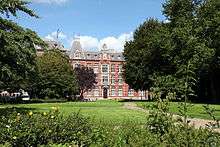
Buildings at the "Vroenhof" central square | |||
| |||
 | |||
| Coordinates: 50°47′N 5°42′E / 50.783°N 5.700°E | |||
| Country | Netherlands | ||
| Province | Limburg (Netherlands) | ||
| Municipality | Eijsden-Margraten | ||
| Area(2006) | |||
| • Total | 20.76 km2 (8.02 sq mi) | ||
| • Land | 19.75 km2 (7.63 sq mi) | ||
| • Water | 1.01 km2 (0.39 sq mi) | ||
| Population (1 January 2007) | |||
| • Total | 7,000 | ||
| • Density | 589/km2 (1,530/sq mi) | ||
| Source: CBS, Statline. | |||
| Time zone | CET (UTC+1) | ||
| • Summer (DST) | CEST (UTC+2) | ||


Eijsden should not be confused with the village of Eisden in the Belgian province of Limburg.
Eijsden (![]() pronunciation ) (Limburgish: Èèsjde) is a place situated in the very south of the European country The Netherlands.
There it is located in the southeastern part of the province of Limburg.
pronunciation ) (Limburgish: Èèsjde) is a place situated in the very south of the European country The Netherlands.
There it is located in the southeastern part of the province of Limburg.
Until January 1, 2011 Eijsden was the main village in a municipality with the same name. On that date this municipality merged with the neighbouring one of Margraten, resulting in nowadays Eijsden-Margraten municipality, in which Eijsden (with about 7.000 inhabitants) again is the biggest place.
This village is one of the most southerly places in the Netherlands, for in its south it is extending up to the most southerly part of the border between the Netherlands and Belgium.
The Meuse river, coming from France and Belgium, here enters its third and final flowing country, the Netherlands. From here on its name in Dutch is (de (= the)) "Maas". Running northward to Eijsden's west it locally forms the westerly frontier of the last mentioned country with Belgium.
A smaller stream, the Voer, coming from Belgium, drains into the Meuse river in this place.
History
Eijsden is one of the older places in the country. Its name is supposed to be derived of the Germanic word for aspen forest. Excavations have revealed a Roman settlement. In the Middle Ages, this settlement developed to a village. After the (feudal) Middle Ages, in the seventeenth century Eijsden gained in economic strength because of its position near the Dutch-Belgian frontier on the Meuse river. Its function as a trading and shipping centre attracted settlement of well-to-do merchants from Holland. This period of prosperity ended in the Napoleonic era when, for a time, the area ceased to be a frontier.
Former municipality
The former Eijsden municipality was composed of several population centres, of which the one named Eijsden was the largest, with 7000 inhabitants. The other population centres (now all part of "Eijsden-Margraten") were:
- Breust
- Hoog- en Laag Caestert
- Gronsveld
- Mariadorp
- Mesch
- Oost-Maarland
- Rijckholt
- Withuis
Constituing quarters
Nowadays the administrative population centre of Eijsden in the municipality of Eijsden-Margraten is formed by several neighbourhoods of which most are more or less separately situated and have their own history:
- Breust, the most northern part of the place, is a former municipality of its own, now forming one quarter with Eijsden itself and including several newbuilt neighbourhoods.
- Eijsden itself.
- Mariadorp, situated to the east of Eijsden itself.
- Laag-Caestert, together with Hoog-Caestert and Withuis forming the southern part of the place.
- Hoog-Caestert, situated to the east of Laag-Caestert.
- Withuis, situated to the east of Hoog-Caestert. In fact this is only the northerly part of the relevant township; the other part is situated across the frontier in Belgium.
Economy
Apart from trading and shipping, the Eijsden economy traditionally has had an agricultural character, with a focus on fruit growing. At one time, in Eijsden the Netherlands' largest local fruit tree area was situated. In the second half of the 20th century, many orchards were replaced by housing, dairy farming and industry.
In 1870, a zinc white factory brought industrial activity to the municipality, along with jobs and air pollution. The number of jobs originally was about 700; by now some 300 are left.
As a result of the relatively vast housing projects in the northern part, Eijsden nowadays is largely residential.
Sights
- The seventeenth century Renaissance style castle of Eijsden (according to the relevant Unesco-list) is one of the top hundred buildings in the country.
- A stylish former monastery.
- The historical "Vroenhof" central square.
- Four monumental water mills on the Voer river.
- Two centuries old church buildings.
Music
In the municipality of Eijsden two military bands are based ('the blue' and 'the red'), of which the first mentioned at contests competes in the second highest international division and the last mentioned to the highest.
In 2013, like in 2009, the last mentioned (the "Koninklijke Harmonie Sainte Cécile)" was the winner in the World Concert Division of the fouryearly World Music Contest, a competition for professional, amateur and military bands, held in Kerkrade.
The first mentioned, (the "Koninklijke Oude Harmonie Sainte Cécile)" ended second in the First Concert Division [1]
Famous natives of Eijsden
- Eugène Dubois- Anatomist/Anthropologist
- Jo Maas, former cyclist, stage winner and seventh in end-classification of 1978 Tour de France.
- Jacques Vriends Dutch writer of children books
Gallery
.JPG) Meuse river enters The Netherlands at Eijsden |
 Eijsden's 17th-century castle at Laag-Caestert |
 View of a historical street, the Diepstraat, that (downwards) leads to the river bank |
References
External links
| Wikimedia Commons has media related to Eijsden. |
Coordinates: 50°47′N 5°42′E / 50.783°N 5.700°E