Effie, Minnesota
| Effie, Minnesota | |
|---|---|
| City | |
|
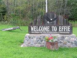
Giant mosquito (and welcome sign) welcomes travelers to Effie | |
 Location of the city of Effie within Itasca County, Minnesota | |
| Coordinates: 47°50′26″N 93°38′17″W / 47.84056°N 93.63806°W | |
| Country | United States |
| State | Minnesota |
| County | Itasca |
| Area[1] | |
| • Total | 3.64 sq mi (9.43 km2) |
| • Land | 3.64 sq mi (9.43 km2) |
| • Water | 0 sq mi (0 km2) |
| Elevation | 1,388 ft (423 m) |
| Population (2010)[2] | |
| • Total | 123 |
| • Estimate (2012[3]) | 123 |
| • Density | 33.8/sq mi (13.1/km2) |
| Time zone | Central (CST) (UTC-6) |
| • Summer (DST) | CDT (UTC-5) |
| ZIP code | 56639 |
| Area code(s) | 218 |
| FIPS code | 27-18260[4] |
| GNIS feature ID | 0656123[5] |
Effie is a city in Itasca County, Minnesota, United States. The population was 123 at the 2010 census.[6]
Minnesota State Highways 1 and 38 are two of the main routes in the community.
History
A post office was established in Effie in 1903.[7] The community was named for Effie Wenaus, the daughter of the first postmaster.[8]
Geography
According to the United States Census Bureau, the city has a total area of 3.64 square miles (9.43 km2), all of it land.[1]
Demographics
| Historical population | |||
|---|---|---|---|
| Census | Pop. | %± | |
| 1950 | 202 | — | |
| 1960 | 195 | −3.5% | |
| 1970 | 165 | −15.4% | |
| 1980 | 141 | −14.5% | |
| 1990 | 130 | −7.8% | |
| 2000 | 91 | −30.0% | |
| 2010 | 123 | 35.2% | |
| Est. 2015 | 123 | [9] | 0.0% |
2010 census
As of the census[2] of 2010, there were 123 people, 48 households, and 29 families residing in the city. The population density was 33.8 inhabitants per square mile (13.1/km2). There were 68 housing units at an average density of 18.7 per square mile (7.2/km2). The racial makeup of the city was 95.9% White, 0.8% African American, 1.6% Asian, and 1.6% from two or more races.
There were 48 households of which 31.3% had children under the age of 18 living with them, 47.9% were married couples living together, 8.3% had a female householder with no husband present, 4.2% had a male householder with no wife present, and 39.6% were non-families. 31.3% of all households were made up of individuals and 12.5% had someone living alone who was 65 years of age or older. The average household size was 2.56 and the average family size was 3.24.
The median age in the city was 32.8 years. 26.8% of residents were under the age of 18; 8.9% were between the ages of 18 and 24; 26.8% were from 25 to 44; 22.7% were from 45 to 64; and 14.6% were 65 years of age or older. The gender makeup of the city was 51.2% male and 48.8% female.
2000 census
As of the census[4] of 2000, there were 91 people, 36 households, and 24 families residing in the city. The population density was 22.8 people per square mile (8.8/km²). There were 56 housing units at an average density of 14.0 per square mile (5.4/km²). The racial makeup of the city was 97.80% White and 2.20% Asian. Hispanic or Latino of any race were 1.10% of the population.
There were 36 households out of which 27.8% had children under the age of 18 living with them, 61.1% were married couples living together, 2.8% had a female householder with no husband present, and 33.3% were non-families. 30.6% of all households were made up of individuals and 13.9% had someone living alone who was 65 years of age or older. The average household size was 2.53 and the average family size was 3.25.
In the city the population was spread out with 28.6% under the age of 18, 7.7% from 18 to 24, 25.3% from 25 to 44, 20.9% from 45 to 64, and 17.6% who were 65 years of age or older. The median age was 37 years. For every 100 females there were 122.0 males. For every 100 females age 18 and over, there were 116.7 males.
The median income for a household in the city was $31,250, and the median income for a family was $29,583. Males had a median income of $21,250 versus $21,875 for females. The per capita income for the city was $14,606. There were 7.4% of families and 5.2% of the population living below the poverty line, including no under eighteens and 18.5% of those over 64.
Events
Effie is home to The Effie North Star Stampede.[11]
References
- 1 2 "US Gazetteer files 2010". United States Census Bureau. Retrieved 2012-11-13.
- 1 2 "American FactFinder". United States Census Bureau. Retrieved 2012-11-13.
- ↑ "Population Estimates". United States Census Bureau. Retrieved 2013-05-28.
- 1 2 "American FactFinder". United States Census Bureau. Retrieved 2008-01-31.
- ↑ "US Board on Geographic Names". United States Geological Survey. 2007-10-25. Retrieved 2008-01-31.
- ↑ "2010 Census Redistricting Data (Public Law 94-171) Summary File". American FactFinder. U.S. Census Bureau, 2010 Census. Retrieved 23 April 2011.
- ↑ "Itasca County". Jim Forte Postal History. Retrieved 12 July 2015.
- ↑ Upham, Warren (1920). Minnesota Geographic Names: Their Origin and Historic Significance. Minnesota Historical Society. p. 254.
- ↑ "Annual Estimates of the Resident Population for Incorporated Places: April 1, 2010 to July 1, 2015". Retrieved July 2, 2016.
- ↑ "Census of Population and Housing". Census.gov. Retrieved June 4, 2015.
- ↑ "North Star Stampede Rodeo". Retrieved 2 October 2012.
Municipalities and communities of Itasca County, Minnesota, United States | ||
|---|---|---|
| Cities | 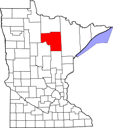 | |
| Townships |
| |
| Unorganized territories | ||
| CDPs | ||
| Unincorporated communities | ||
| Indian reservations | ||
| Footnotes | ‡This populated place also has portions in an adjacent county or counties | |
Coordinates: 47°50′25″N 93°38′35″W / 47.84028°N 93.64306°W