Eclectic, Alabama
| Eclectic, Alabama | |
|---|---|
| Village | |
|
Eclectic, Alabama | |
 Location in Elmore County and the state of Alabama | |
| Coordinates: 32°38′28″N 86°2′18″W / 32.64111°N 86.03833°W | |
| Country | United States |
| State | Alabama |
| County | Elmore |
| Area | |
| • Total | 4.2 sq mi (11.1 km2) |
| • Land | 4.2 sq mi (11 km2) |
| • Water | 0 sq mi (0.1 km2) |
| Elevation | 581 ft (177 m) |
| Population (2013) | |
| • Total | 1,007 |
| • Density | 246.9/sq mi (93.4/km2) |
| Time zone | Central (CST) (UTC-6) |
| • Summer (DST) | CDT (UTC-5) |
| ZIP code | 36024 |
| Area code(s) | 334 |
| FIPS code | 01-22816 |
| GNIS feature ID | 0117848 |
| Website | http://www.townofeclectic.com |

Eclectic is a town in Elmore County, Alabama, United States. It incorporated in 1907.[1] At the 2010 census the population was 1,001. It is part of the Montgomery Metropolitan Statistical Area.
History
Eclectic was founded by Dr. M. L. Fielder, a practitioner of eclectic medicine, hence the name.[2] It has frequently been noted on lists of unusual place names.[3][4]
The first post office in Eclectic was established in 1879.[5]
Geography
Eclectic is located at 32°38′29″N 86°2′19″W / 32.64139°N 86.03861°W (32.641285, -86.038571).[6]
According to the U.S. Census Bureau, the town has a total area of 4.3 square miles (11 km2), of which 4.2 square miles (11 km2) is land and 0.1 square miles (0.26 km2) (1.17%) is water.
Demographics
| Historical population | |||
|---|---|---|---|
| Census | Pop. | %± | |
| 1910 | 315 | — | |
| 1920 | 555 | 76.2% | |
| 1930 | 678 | 22.2% | |
| 1940 | 606 | −10.6% | |
| 1950 | 715 | 18.0% | |
| 1960 | 926 | 29.5% | |
| 1970 | 1,184 | 27.9% | |
| 1980 | 1,124 | −5.1% | |
| 1990 | 1,087 | −3.3% | |
| 2000 | 1,037 | −4.6% | |
| 2010 | 1,001 | −3.5% | |
| Est. 2015 | 1,029 | [7] | 2.8% |
| U.S. Decennial Census[8] 2013 Estimate[9] | |||
As of the census[10] of 2000, there were 1,037 people, 409 households, and 280 families residing in the town. The population density was 244.7 people per square mile (94.4/km2). There were 459 housing units at an average density of 108.3 per square mile (41.8/km2). The racial makeup of the town was 78.11% White, 19.19% Black or African American, 0.96% Native American, 0.10% Asian, 0.87% from other races, and 0.77% from two or more races. 1.83% of the population were Hispanic or Latino of any race.
There were 409 households out of which 33.3% had children under the age of 18 living with them, 45.7% were married couples living together, 16.9% had a female householder with no husband present, and 31.3% were non-families. 29.1% of all households were made up of individuals and 14.7% had someone living alone who was 65 years of age or older. The average household size was 2.54 and the average family size was 3.14.
In the town the population was spread out with 30.1% under the age of 18, 6.4% from 18 to 24, 28.4% from 25 to 44, 19.0% from 45 to 64, and 16.1% who were 65 years of age or older. The median age was 36 years. For every 100 females there were 85.2 males. For every 100 females age 18 and over, there were 79.9 males.
The median income for a household in the town was $30,906, and the median income for a family was $31,855. Males had a median income of $29,554 versus $18,162 for females. The per capita income for the town was $14,131. About 20.5% of families and 25.5% of the population were below the poverty line, including 32.6% of those under age 18 and 23.4% of those age 65 or over.
2010 census
As of the census[11] of 2010, there were 1,001 people, 399 households, and 266 families residing in the town. The population density was 238.3 people per square mile (90.2/km2). There were 438 housing units at an average density of 104.3 per square mile (39.5/km2). The racial makeup of the town was 86.4% White, 11.0% Black or African American, 0.4% Native American, 0.0% Asian, 0.0% from other races, and 2.1% from two or more races. 1.3% of the population were Hispanic or Latino of any race.
There were 399 households out of which 29.8% had children under the age of 18 living with them, 50.4% were married couples living together, 14.0% had a female householder with no husband present, and 33.3% were non-families. 29.6% of all households were made up of individuals and 15.0% had someone living alone who was 65 years of age or older. The average household size was 2.51 and the average family size was 3.14.
In the town the population was spread out with 25.5% under the age of 18, 8.1% from 18 to 24, 23.0% from 25 to 44, 25.9% from 45 to 64, and 17.6% who were 65 years of age or older. The median age was 39.9 years. For every 100 females there were 82.3 males. For every 100 females age 18 and over, there were 79.8 males.
The median income for a household in the town was $34,750, and the median income for a family was $42,188. Males had a median income of $35,815 versus $27,684 for females. The per capita income for the town was $19,181. About 8.6% of families and 13.1% of the population were below the poverty line, including 22.4% of those under age 18 and 5.7% of those age 65 or over.
Notable people
- William S. Eubanks, former American Oil executive
- Ben Grubbs, former offensive guard for Auburn University, who currently plays for the New Orleans Saints
- Aubrey Hornsby, former U.S. Army officer and pioneer aviator
- Randy Phillips, airman in the United States Air Force
- Ludd M. Spivey, president of Florida Southern College from 1925 to 1957
Gallery
-

Eclectic's welcome sign.
-
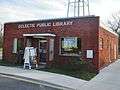
Eclectic Public Library
-
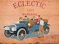
A mural in downtown Eclectic, Alabama.
References
- ↑ "Eclectic - Encyclopedia of Alabama". Retrieved 15 September 2016.
- ↑ Gallant, Frank K. (2012). A Place Called Peculiar: Stories about Unusual American Place-Names. Courier Dover Publications. p. 4.
- ↑ Thompson, George E. (2009). You Live Where?: Interesting and Unusual Facts about where We Live. iUniverse. p. 2.
- ↑ Parker, Quentin (2010). Welcome to Horneytown, North Carolina, Population: 15: An insider's guide to 201 of the world's weirdest and wildest places. Adams Media. pp. ix.
- ↑ Helbock, Richard W. (2007) United States Post Offices, Volume VIII - The Southeast, p. 76. Scappoose, Oregon: La Posta Publications
- ↑ "US Gazetteer files: 2010, 2000, and 1990". United States Census Bureau. 2011-02-12. Retrieved 2011-04-23.
- ↑ "Annual Estimates of the Resident Population for Incorporated Places: April 1, 2010 to July 1, 2015". Retrieved July 2, 2016.
- ↑ "U.S. Decennial Census". Census.gov. Retrieved June 6, 2013.
- ↑ "Annual Estimates of the Resident Population: April 1, 2010 to July 1, 2013". Retrieved June 3, 2014.
- ↑ "American FactFinder". United States Census Bureau. Retrieved 2008-01-31.
- ↑ "American FactFinder". United States Census Bureau. Retrieved 2015-07-22.
External links
Coordinates: 32°38′29″N 86°02′19″W / 32.641285°N 86.038571°W
Municipalities and communities of Elmore County, Alabama, United States | ||
|---|---|---|
| Cities | 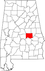 | |
| Towns | ||
| CDPs | ||
| Unincorporated communities | ||
| Footnotes | ‡This populated place also has portions in an adjacent county or counties | |