Eau Claire, Calgary
| Eau Claire | |
|---|---|
| Neighbourhood | |
|
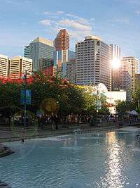
Festival plaza in Eau Claire | |
 Eau Claire Location of Eau Claire in Calgary | |
| Coordinates: 51°03′11″N 114°04′17″W / 51.05306°N 114.07139°WCoordinates: 51°03′11″N 114°04′17″W / 51.05306°N 114.07139°W | |
| Country |
|
| Province |
|
| City |
|
| Quadrant | SW |
| Ward | 7 |
| Established | 1885 |
| Government[1] | |
| • Mayor | Naheed Nenshi |
| • Administrative body | Calgary City Council |
| • Councillor | Druh Farrell |
| Area | |
| • Total | 0.4 km2 (0.2 sq mi) |
| Elevation | 1,045 m (3,428 ft) |
| Population (2006)[2] | |
| • Total | 1,717 |
| • Average Income | $80,210 |
| Website | Eau Claire Community Association |
The neighbourhood of Eau Claire in Calgary, Alberta, Canada is located immediately north of Downtown, and south of the Bow River and north of 4th Avenue. A mix of riverside condominiums, shopping, restaurants, hotels, a large public plaza and urban parkland make Eau Claire one of Calgary's most popular areas. Contained within Eau Claire is the city's Festival District.
The area, which was developed from reclaimed industrial land, fronts the Bow River and sits immediately north of 3rd Avenue South. North of Eau Claire is Prince's Island Park, a large urban park on an island in the Bow River and the site of many summer festivals, including the Calgary Folk Music Festival, Carifest, Shakespeare in the Park and various busking happenings. Within Eau Claire is Eau Claire Market and a variety of pubs and restaurants. It is also located on the city's large network of pedestrian pathways and trails, along the Bow River pathway.
History
The name Eau Claire derives from one of Calgary's original industries - a sawmill transplanted from Eau Claire, Wisconsin and staffed by mostly Norwegian mill workers. The area on the banks of the Bow River was selected in 1886 for its easy access to fallen timber.[3] The community was subsequently named for the Eau Claire Lumber Company.
Eau Claire Plaza, at the core of the Festival District is currently undergoing a major modernization and redevelopment to better integrate it with the city, Prince's Island, Eau Claire Market, Barclay Mall and the other surrounding hotels, restaurants and businesses. The community has an area redevelopment plan in place.[4]
Demographics
In the City of Calgary's 2012 municipal census, Eau Claire had a population of 1,851 living in 1,328 dwellings, an 8.2% increase from its 2011 population of 1,711.[5] With a land area of 0.5 km2 (0.19 sq mi), it had a population density of 3,700/km2 (9,600/sq mi) in 2012.[6][5]
Residents in this community had a median household income of $80,210 in 2000, and there were 21.8% low income residents living in the neighbourhood.[7] As of 2000, 32.7% of the residents were immigrants. A proportion of 98% of the buildings were condominiums or apartments, and 38.7% of the housing was used for renting.[2]
It is represented in the Calgary City Council by the Ward 7 councillor.
Eau Claire Market

Eau Claire Market is the focal point of the neighbourhood. It sits immediately south of the Bow River and was built on former industrial land. The mall is home to several unique and "one of a kind" shops and galleries, a six screen Cineplex Odeon multiplex, a food court and several restaurants. To coincide with the reconfiguration of Eau Claire Plaza, plans are currently in development to demolish and completely rebuild the market which has declined in popularity in recent years. The new market will likely cater to a larger and more diverse demographic to better serve the residential community at large.
References
- ↑ "Calgary Elections". City of Calgary. October 21, 2013. Retrieved October 22, 2013.
- 1 2 City of Calgary (2006). "Eau Claire Community Statistics" (PDF). Retrieved 2007-05-11.
- ↑ Ward, Tom (1975). Cowtown : an album of early Calgary. Calgary: City of Calgary Electric System, McClelland and Stewart West. p. 182. ISBN 0-7712-1012-4.
- ↑ City of Calgary Planning (2005). "Eau Claire Area Redevelopment Plan" (PDF). Archived from the original (PDF) on 2007-08-09. Retrieved 2007-05-11.
- 1 2 "2012 Civic Census Results" (PDF). City of Calgary. 2012. Retrieved February 4, 2013.
- ↑ "Community Boundaries" (Esri shapefile). City of Calgary. Retrieved February 5, 2013.
- ↑ City of Calgary (2004). "Ward 7 Profile" (PDF). Retrieved 2007-05-11.
External links
 |
Sunnyside Memorial Drive |
Crescent Heights Prince's Island Park |
Bridgeland Bow River |
|
| |
Chinatown | |||
| ||||
| | ||||
| Downtown West End | Downtown | Downtown East Village |