Eastern Development Region, Nepal
| पूर्वाञ्चल विकास क्षेत्र Purwānchal Bikās Kshetra | |
|---|---|
| Regions | |
 | |
| Country |
|
| Region | Eastern Development Region |
| Headquarters | Dhankuta, Dhankuta District, Kosi Zone |
| Area | |
| • Total | 28,456 km2 (10,987 sq mi) |
| Population (2011 Census) | |
| • Total | 5,811,555 |
| pop. note | |
| Time zone | NPT (UTC+5:45) |
The Eastern Development Region (Nepali: पुर्वाञ्चल विकास क्षेत्र, Purwānchal Bikās Kshetra) is one of Nepal's five development regions. It is located at the eastern end of the country with headquarters at Dhankuta.The fourteen administrative zones of Nepal are split between five development regions, one of which is the Eastern (Purwanchal) Region. The town of Dhankuta is the capital of the Eastern Region, as well as the capital of the Dhankuta District.[1]
The Eastern Sector embraces the snow-capped peaks including Mt. Everest, Mt.Kangchenjunga, Mt. Makalu with Solukhumbu, Sankhuwasabha, and Taplejung districts towards the north, the jungle clad hill tracts of Okhaldhunga, Khotang, Bhojpur, Tehrathum and Panchthar in the Mid and the alluvial fertile plains of Siraha, Saptari, Sunsari, Morang and Jhapa is a veritable accumulation of flora and fauna in all its comprehendible multiplicities in the south. This is not only the most tempting and captivating part of Nepal displaying nature's bounty at its best but also pretends a wide diversity of cultures woven together by the underlying thread of nationalism. The profusion of natural resources connected with the amiable and warm nature of the inhabitants makes the region uniquely different.[2]
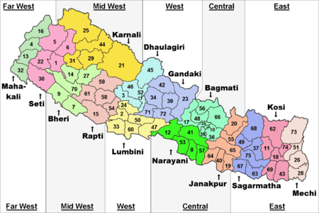
Administrative Division of Eastern Development Region of Nepal
It comprises three zones:
Mountains
Mt. Everest, Kanchanjunga, Makalu, Lhotse, Pumori are the main mountains of Eastern Development Region.
Protected Areas
Sagarmatha National Park, Makalu Barun National Park, Kanchanjunga Conservation Area and Koshi Tappu Wild Life Reserve are the main protected area of this region.
Geography
The Eastern Development Region consists of about 28,456 square kilometers of area. Like other development regions, this eastern region also has the same three-fold geographical division: Himalayan in the north, Hilly in the middle and Terai in the southern part of Nepal, varying between an altitude of 60 m and 8,848 m.. Terai, extended from east to west, is made up of alluvial soil. To the west of Koshi River, in between Mahabharat and Churia, there elongates a valley called Inner Terai. Churai ranges, Mahabharat, hills of various height, basins, tars and valleys form hilly region. Some parts of this region are favourable for agriculture but some other parts are not. Himalayan region, in the north, consists of many mountains ranges. Mahalangur, Kumbhakarna, Umvek, Lumba Sumba and Janak are some of them. The highest mountain in the world, Mount Everest (8848 metre); and the third highest mountain, Kangchenjunga (8598 meters) lie in this region.
Nepal’s lowest point, Kechana Kalan at 60 m, is located in the Jhapa district of this development region. There are many river basins and gentle slopes as well. Churai, Mahabharat, many basins, tars and valleys form the Terai region. Between the Churia and Mahabharat a low land of inner Terai exists. The Koshi river flows through the region with its seven tributaries like Indrawati, Likhu, Tamur, Dudh Kosi, Arun, Tamakoshi and Bhote Koshi (Sunkoshi). There are other rivers as well. Tundra vegetables, coniferous forest, deciduous monsoon forests and sub-tropical evergreen woods are vegetations found here. Sub-tropical, temperate, sub-temperate, and alpine and tundra types of climates are found here.[3]
Cities
The major cities of this region are Biratnagar, Dharan, Dhankuta, Itahari, Rajbiraj, Birtamod and Damak, Gaighat, Lahan, Ilam and Bhadrapur. Other notable places are Namche Bazaar, the town near the base camp of Mt. Everest.
References
- ↑ An overview of the Eastern Region of Nepal
- ↑ "Background : Eastern REgion at a Glance". Nepalarmy.mil.np. Retrieved 2015-06-04.
- ↑ "Physical Environment of Eastern Development Region of Nepal". Imnepal.com. 2012-04-28. Retrieved 2015-06-04.
External links
 |
|
Sikkim, |
| |
| Central Region | |
|||
| ||||
| | ||||
| Bihar, |
West Bengal, |
| Eastern Region (Purwanchal) | ||
|---|---|---|
| Central Region (Madhyamanchal) | ||
| Western Region (Pashchimanchal) | ||
| Mid-Western Region (Madhya Pashchimanchal) | ||
| Far-Western Region (Sudur Pashchimanchal) | ||
Coordinates: 26°59′N 87°20′E / 26.983°N 87.333°E