Eastern Freeway (Melbourne)
| Eastern Freeway Victoria | |
|---|---|
| General information | |
| Type | Freeway |
| Length | 18 km (11 mi) |
| Opened | 1977–1997 |
| Route number(s) |
|
| Former route number |
|
| Major junctions | |
| West end | |
|
for full list see exits and interchanges | |
| East end | |
| Location(s) | |
| Major suburbs / towns | Bulleen, Doncaster, Box Hill North |
| Highway system | |
|
Highways in Australia National Highway • Freeways in Australia Highways in Victoria | |
| |
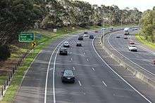
The Eastern Freeway[2] is an urban freeway in eastern Melbourne, the state capital of Victoria, Australia. It is one of the most important freeways in terms of commuting to the city, connecting Alexandra Parade and Hoddle Street in the inner suburbs, with EastLink tollway farther east. It consists of between three and six lanes (including the Hard Shoulder Running lane during peak periods) in each direction, also an inbound transit lane reserved for vehicles with two or more occupants during peak hours.
It is the continually widest freeway in Melbourne, with 12 lanes altogether near the Hoddle Street and Alexandra Parade end.
History
Originally designated F-19 under the 1969 Melbourne Transportation Plan during its construction in the early 1970s, it was supposed to be linked to the then-new Tullamarine Freeway, as well as taking traffic off the Maroondah Highway. Protests from inner Melbourne suburbs residents led it being terminated at Hoddle Street. Its initial route designation was F83 then State Route 83 and now the M3. The current incarnation was constructed in stages from 1977 to 1997:
- 1977 – Hoddle Street to Bulleen Road. Opened in three stages, December 1977. Hoddle Street to Chandler Highway; Chandler Highway to Burke Road; Burke Road to Bulleen Road.[3]
- 1982 – Bulleen Road to Doncaster Road. This 3 km section was opened 3 June 1982, by Minister for Transport, the Hon S M Crabb MP. Originally two lanes in each direction, plus emergency stopping lanes, at a cost of $A24m.[4]
- 1997 – Doncaster Road to Springvale Road. This 7 km extension was opened to traffic in December 1997, at a cost of $A250m.[5]
Originally, the freeway was to terminate at the intersection of Maroondah Highway and Mount Dandenong Road in Ringwood. It was meant to connect to the Eastern Ring Road before that. Instead, the Eastern Ring Road and the last Eastern Freeway extension was merged into one project (Eastlink) and the remainder of the Eastern Freeway reservation was built into the Ringwood bypass, which opened in July 2008.

The first and second stages were controversial and met much opposition due to the first being constructed through the middle of Yarra Bend Park and the second stage to Doncaster Road through parkland now named Koonung Creek Reserve. The first two stages were designed to enable the construction of the Doncaster railway line down the centre of the freeway to Bulleen Road. An extra-wide median strip, which was kept free of support pylons for over-bridges, was provided to allow for the railway. The bridges were designed by Melbourne engineer Bruce Day, with particular attention paid to the aesthetics of each bridge so that they fitted in their landscape, were related to one another, and also provided a variety and progression of design themes.
Land was also reserved from Bulleen Road to Doncaster East to extend the proposed railway line, but the plan fell out of favour in the 1980s and the land was sold.[6] In recent years, amidst growing congestion problems and increased awareness of unsustainable methods of transport in Melbourne, there has been massive local council lobbying (by Melbourne, Yarra and Manningham) and public pressure placed on the State Government for the rail line to be constructed.[7] The final stage, completed in 2008, connected the freeway to the Ringwood Bypass and the Monash and Frankston Freeways.
Route

The Eastern Freeway starts at its junction with Hoddle Street, as an eastern continuation of Alexandra Parade (referred to in VicRoads documents as the Eastern Highway), with five lanes eastbound and two lanes westbound. Three more lanes (that provide an exit to Hoddle Street) join the freeway after it leaves the junction. The freeway narrows to four lanes in each direction near Chandler Highway and Yarra Bend.
The freeway narrows to three lanes just before Bulleen Road, and features a concrete barrier rather than the grassy median that was designed to carry a railway. There is a short four lane section between Tram and Blackburn Roads, then three lanes to the end at Springvale Road, and connects to the EastLink toll road to Ringwood and Frankston. The freeway was unique in that it did not connect to any other freeway prior to EastLink being built.
The travel time on the Eastern Freeway in each direction, is 13 minutes. (5 minutes between Springvale Road and Doncaster Road and 8 minutes between Doncaster Road and Hoddle Street).
The usual peak period travel time, is between 16–26 minutes. However, during times of extreme congestion, including residual from an incident, the travel time can go well beyond half an hour.
Safety
Despite the inherent danger in small and large vehicles travelling at high speeds, the freeway is generally considered one of the safest in Melbourne, with minimal changes of elevation, a flowing route, ample shoulder space and well-maintained safety barriers. Long sections of the freeway suffer from low lighting levels due to its route and proximity to residential areas.
In the seven years preceding and including 2009, six people died in a section of the freeway known as the Bulleen Bend.[8] This is the tightest bend in the freeway's length, between the Bulleen and Doncaster Road interchanges. Despite the relatively tight bend and 100 km/h (62 mph) limit, there were few safety barriers on the extremities of the road surface, leaving nothing between the cars and the trees on the road shoulder. Flexible barriers were installed along lengths of the freeway in an attempt to improve safety. These measures reduced the relative risk of casualty crashes by approximately 75 percent.[9]
East West Link
The Eastern Freeway has no connecting freeways at its western end in Clifton Hill. As a result, traffic from the Eastern Freeway is released westward along Alexandra Parade and north-south along Hoddle Street. There have been proposals to extend the freeway further west to connect with the CityLink network, but none have been constructed to date.[10]
On 1 March 2007, the Victorian Government announced a study linking the major freeways conducted by international transport expert Sir Rod Eddington. The Eddington Transport Report was released in early 2008 and outlined 20 main recommendations for the city, including a tunnel from the Eastern Freeway to CityLink under Royal Park.[11] The newly-elected state Liberal government announced in 2013 that they would commence construction of the tunnel. This announcement sparked heated public debate and protests both in favour[12] and against[13] the proposal until the newly-elected Labor government renounced the contracts signed by the previous government in 2015 and scrapped the project.[14]
One aspect of the East West Link proposal was to widen the Eastern Freeway between Hoddle Street and Tram Road in Doncaster.[15][16] While the exact details of the proposal were not released before the project was abandoned, this was opposed by residents and councils along its length.[17][18]
Speed enforcement
The entire freeway has a 100 km/h (62 mph) speed limit. There are no fixed speed cameras, however Victoria Police regularly patrol the full length of the freeway to enforce the speed limit. VicRoads also operates a network of CCTV cameras across the entire length of the freeway and abnormal traffic movements by vehicles are reported to Victoria Police.
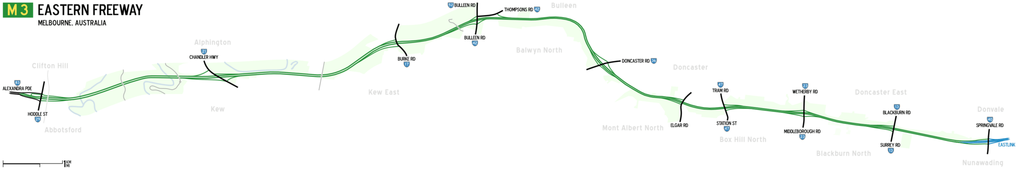
Exits and interchanges
| LGA | Location | km[19] | mi | Destinations | Notes |
|---|---|---|---|---|---|
| Yarra | Collingwood – Abbotsford – Clifton Hill tripoint | 0 | 0.0 | Western freeway terminus: continues as Alexandra Parade | |
| Boroondara | Kew | 3 | 1.9 | ||
| Kew East – Balwyn North boundary | 6 | 3.7 | Eastbound exit and westbound entrance | ||
| Balwyn North | 8 | 5.0 | |||
| 10 | 6.2 | ||||
| Manningham–Whitehorse boundary | Mont Albert North – Doncaster – Box Hill North tripoint | 12 | 7.5 | Elgar Road – Doncaster, Burwood | Eastbound exit and westbound entrance |
| Doncaster – Box Hill North boundary | 13 | 8.1 | Westbound exit and eastbound entrance | ||
| Whitehorse | Box Hill North – Blackburn North boundary | 14 | 8.7 | ||
| Blackburn North | 16 | 9.9 | Eastbound exit and westbound entrance | ||
| Whitehorse–Manningham boundary | Nunawading–Donvale boundary | 18 | 11 | Eastern freeway terminus at single point urban interchange; continues as EastLink | |
Freeway map
See also
![]() Australian Roads portal
Australian Roads portal
References
- ↑ Route Numbering History, Main Roads Victoria. Retrieved 4 September 2013.
- ↑ M3 Eastern Freeway – Melbourne's gateway to the east, Main Roads Victoria. Retrieved 4 September 2013.
- ↑ Country Roads Board Victoria. Sixty-Fifth Annual Report: for the year ended 30 June 1978. Melbourne, Victoria: Government Printer, 1978. p. 7
- ↑ Country Roads Board Victoria. 69th Annual Report. 1981-1982. Kew, Victoria: Country Roads Board Victoria, 1982. p. 11
- ↑ Vicroads. Vicroads Annual Report 1997-98. Kew, Victoria: Vicroads, 1998, p. 31
- ↑ Stephen Cauchi (February 1998). "Whatever Happened to the Proposed Railway to Doncaster East". Newsrail. Vol. 26 no. 2. Australian Railway Historical Society (Victorian Division). pp. 40–44.
- ↑ Newman, Peter (12 November 2005). "How to fix Melbourne's woes". The Age. Retrieved 12 July 2016.
- ↑ Rolfe, Peter (10 October 2009). "Four dead on Victorian roads". Herald Sun. Retrieved 12 July 2016.
- ↑ Candappa, Nimmi; D'E lia, Angelo; Corben, Bruce; Newstead, Stuart. "Evaluation of the Effectiveness of flexible barriers on Victorian roads" (PDF). Monash University Accident Research Centre. Retrieved 12 July 2016.
- ↑ Dubecki, Larissa (14 August 2003). "Tunnel under Royal Park to link freeways shelved". The Age. Retrieved 12 July 2016.
- ↑ Millar, Royce; Lucas, Clay; Rood, David; Morton, Adam (3 April 2008). "$18 billion to link east and west". The Age. Retrieved 12 July 2016.
- ↑ Stanton, Kate (8 August 2015). "East West Link protesters call for road to be built". The Age. Retrieved 12 July 2016.
- ↑ "Road protesters confront police over East West Link drilling". Australian Broadcasting Corporation. 9 January 2014. Retrieved 12 July 2016.
- ↑ Newman, Peter (3 December 2014). "The East-West Link is dead – a victory for 21st-century thinking". The Conversation. Retrieved 12 July 2016.
- ↑ "East West Link Enabling Works – Attachment D" (PDF). Victorian Government. Retrieved 12 July 2016.
- ↑ Campbell, James (30 June 2013). "State Government reveals plans to widen the Eastern Fwy to make traffic-busting superlink". Herald Sun. Retrieved 12 July 2016.
- ↑ "East West Link submission" (PDF) (Letter). Letter to. City of Boroondara. 12 December 2013. Retrieved 12 July 2016.
- ↑ "Traffic Issues". Friends of Banyule. Retrieved 12 July 2016.
- ↑ Google (7 March 2015). "Eastern Freeway (Melbourne)" (Map). Google Maps. Google. Retrieved 7 March 2015.
| Tollways | ||
|---|---|---|
| Freeways | ||
| Highways |
| |
| Bypasses | ||
| Bridges and tunnels | ||
| Proposals | ||
| ||