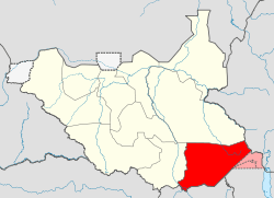
Eastern Equatoria
| Western Equatoria شرق الاستوائية | |||||
| State of Sudan (1976 - 2011) State of South Sudan (2011 - 2015) | |||||
| |||||
|
Flag | |||||
 | |||||
| Capital | Torit | ||||
| History | |||||
| • | Creation as a state of Sudan[1] | 1976 | |||
| • | Became a state of South Sudan after independence from Sudan | 2011 | |||
| • | Reorganisation of states | 2015 | |||
| Area | |||||
| 73,472.01 km2 (28,368 sq mi) | |||||
| Population | |||||
| • | 2008 | 906,126 | |||
Eastern Equatoria was one of the ten states of South Sudan. It has an area of 73,472 km².[2] The capital is Torit.
Geography
The state shared international borders with Uganda in the south, with Kenya in the south-east and with Ethiopia in the north-east. Domestically, it was bordered by Central Equatoria in the west and Jonglei in the north. The Ilemi Triangle in the east, between Eastern Equatoria and Lake Turkana, is or has been disputed among all three abutting states (South Sudan, Kenya and Ethiopia).
Population
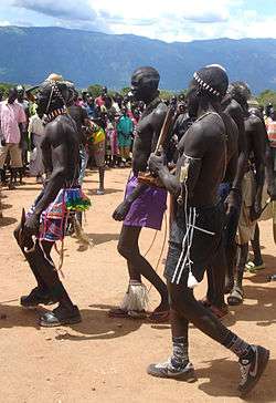
The state had 906,126 people in 2008 (32/sq mi). Eastern Equatoria state was home to several different ethnic groups. The Toposa, Jie and Nyangathom live in the Kapeota counties in the east of the state. The Didinga, Dodoth and Boya live in Budi county around Chukudum. Further west, Lopa/Lafon, Torit and Ikwoto counties are inhabited by the Otuho, Lopit, Lango, Pari, and Tenet people who inhabit a portion of Lopit hills after they split from Didinga and Murle early in 19th century and Lokoya of Lowoi. The Acholi, Madi, Iyire and Ofiriha people live in the westernmost Magwi county.[3]
Most of the inhabitants of the former Eastern Equatoria live by subsistence farming, and also raise cattle, sheep and goats. Some of the crops arre sold, while most are consumed locally. The Didinga Hills in Buda county have rich and fertile soil that is used for cultivation of tobacco, potatoes, maize, and Dura.[3]
Government
The executive head of the State is the Governor, who is elected. The Governor appoints ministers, advisors, and the Executive Directors to the Counties. The Counties in turn, are ruled by the democratically elected Local Government Councils headed by the County Commissioner [4] The state legislature is elected, with the first elections being held in April 2010.
Administrative divisions

Eastern Equatoria, like other states in South Sudan, was sub-divided into counties. These are further divided into Payams, then Bomas. Each county is headed by a County Commissioner, elected by the people of a County as the head of the local government in the County.
Counties were originally larger, but were subdivided in part to ensure that the different communities have full representation. Thus Torit County was subdivided into Torit, Lopa/Lafon and Ikwoto counties, and Greater Kapoeta was divided into Budi County and Kapoeta county, which in turn was divided into Kapoeta North, South and East counties.
Counties and their commissioners as of 2011 were:[5]
| County | Capital | Commissioner |
|---|---|---|
| Torit County | Torit | Felix Otuduha Siro |
| Lafon County | Lafon | Hon Thomas Udwar Augustino |
| Magwi County | Magwi | |
| Ikotos County | Ikwoto | Peter Lokeng Lotone |
| Budi County | Chukudum | |
| Kapoeta North County | Riwoto | Lokai Iko Loteyo |
| Kapoeta South County | Kapoeta | Martin Lorika Lojam |
| Kapoeta East County | Narus | Titos Lokwacuma Lotyam |
Health
As of 2014, this was one of the last areas in the world where cases of Guinea worm disease are found, with twelve of the 17 reported cases occurring "in one small pocket of Eastern Equatoria State," according to NPR.[6]
See also
References
- ↑ The State of Post-conflict Reconstruction: Land, Urban Development and State-building in Juba, Southern Sudan. p. 48.
- ↑ South Sudan at GeoHive
- 1 2 "Focus On South: Facts About Eastern Equatoria State". Sudan Vision Daily. Retrieved 2011-07-07.
- ↑ Local Government Bill 2009
- ↑ "Eastern Equatoria State". Gurtong. Retrieved 2011-07-07.
- ↑ Doucleff, Michaeleen (2014-07-08). "Going, Going, Almost Gone: A Worm Verges On Extinction". NPR : Goats and Soda. Retrieved 2014-07-09.
External links
| Counties | | |
|---|---|---|
| Principal towns | ||
| Airports | ||
| Rivers | ||
| Mountains | ||
| Communities | ||
Former States of South Sudan (2011–15) | ||
|---|---|---|
Special administration area to hold referendum (postponed indefinitely) | ||