East Tampa, Florida
| East Tampa | |
|---|---|
| Unincorporated community | |
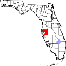
 East Tampa  East Tampa Location within the state of Florida | |
| Coordinates: 27°51′51″N 82°22′49″W / 27.86417°N 82.38028°WCoordinates: 27°51′51″N 82°22′49″W / 27.86417°N 82.38028°W | |
| Country | United States |
| State | Florida |
| County | Hillsborough |
| Elevation | 11 ft (3 m) |
| Time zone | Eastern (EST) (UTC-5) |
| • Summer (DST) | EDT (UTC-4) |
| ZIP codes | 33619 |
| Area code(s) | 813 |
East Tampa is an unincorporated community in Hillsborough County, Florida, United States. Although a separate community, it is a part of the census-designated place (CDP) of Gibsonton.[1] The ZIP code for the community is 33619. It is part of the Palm River-East Tampa census county division (CCD), which recorded an estimate population of 29,112 in 2007.[2]
Geography
East Tampa is located at 27.9 degrees north, 82.4 degrees west (27.8649, 82.38028);[3][4] or about 11.8 miles southeast of Tampa.[5] The elevation for the community is 11 feet above sea level.[6]
East Tampa boundaries include Gibsonton to the south, Interstate 75 to the east, Riverview Drive to the north, and U.S. Highway 41 to the west.
Major roads in East Tampa
Some of the major roads serving the community include:
- Riverview Drive
- U.S. Highway 41
- Interstate 75
Education
The community of East Tampa is served by Hillsborough County Schools.
References
- ↑ URBANIZED AREA OUTLINE MAP (CENSUS 2000) Tampa-St. Petersburg, FL
- ↑ Palm River-East Tampa, Florida (FL) Detailed Profile - city-data.com
- ↑ East Tampa, Hillsborough County, Florida, USA - Maps, Photos ...
- ↑ "US Gazetteer files: 2010, 2000, and 1990". United States Census Bureau. 2011-02-12. Retrieved 2011-04-23.
- ↑ Distance & Driving Directions to East Tampa
- ↑ East Tampa profile from Hometown Locator