East Manchester Township, York County, Pennsylvania
| East Manchester Township, Pennsylvania | |
|---|---|
| Township | |
|
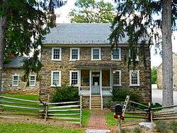
House at the John Rudy County Park | |
 Location in York County and the state of Pennsylvania. | |
| Country | United States |
| State | Pennsylvania |
| County | York |
| Settled | 1735 |
| Incorporated | 1887 |
| Government | |
| • Type | Board of Supervisors |
| Area | |
| • Total | 17.2 sq mi (45 km2) |
| • Land | 16.6 sq mi (43 km2) |
| • Water | 0.6 sq mi (2 km2) |
| Population (2010) | |
| • Total | 7,264 |
| • Density | 420/sq mi (160/km2) |
| Time zone | Eastern (EST) (UTC-5) |
| • Summer (DST) | EDT (UTC-4) |
| Area code(s) | 717 |
East Manchester Township is a township in York County, Pennsylvania, USA. As of the 2010 census, the township population was 7,264.[1]
History
Michael and Magdealena Bixler Farmstead, also known as John Rudy County Park, was listed on the National Register of Historic Places in 2000.[2]
Geography
According to the United States Census Bureau, the township has a total area of 17.2 square miles (45 km2). 16.6 square miles (43 km2) of it is land and 0.6 square miles (1.6 km2) of it (3.43%) is water. The township surrounds the boroughs of Manchester and Mount Wolf, located side by side at the center of the township.
Demographics
As of the census[3] of 2000, there were 5,078 people, 1,926 households, and 1,504 families residing in the township. The population density was 305.5 people per square mile (118.0/km²). There were 1,986 housing units at an average density of 119.5/sq mi (46.1/km²). The racial makeup of the township was 97.40% White, 1.04% African American, 0.20% Native American, 0.67% Asian, 0.26% from other races, and 0.43% from two or more races. Hispanic or Latino of any race were 0.93% of the population.
There were 1,926 households out of which 35.2% had children under the age of 18 living with them, 67.4% were married couples living together, 6.8% had a female householder with no husband present, and 21.9% were non-families. 17.9% of all households were made up of individuals and 7.2% had someone living alone who was 65 years of age or older. The average household size was 2.64 and the average family size was 2.97.
In the township the population was spread out with 24.6% under the age of 18, 5.7% from 18 to 24, 33.5% from 25 to 44, 25.0% from 45 to 64, and 11.2% who were 65 years of age or older. The median age was 37 years. For every 100 females there were 100.8 males. For every 100 females age 18 and over, there were 98.3 males.
The median income for a household in the township was $49,417, and the median income for a family was $56,186. Males had a median income of $38,672 versus $26,506 for females. The per capita income for the township was $20,559. About 1.5% of families and 2.6% of the population were below the poverty line, including 1.5% of those under the age of 18 and 3.4% of those ages 65 and older.
Education
East Manchester Township is served by the Northeastern York School District (one of 500 public school districts in Pennsylvania). Students may also attend one of the Commonwealth's public cyber charter schools at no additional cost to the family or student. The local school district pays the Pennsylvania Department of Education set tuition fee to the cyber charter school that the resident student chooses to attend. By law, Pennsylvania cyber charter school students have access to all extracurriculars and sports programs at the local public school district. Alternatively, the Commonwealth of Pennsylvania permits parents to home school their children or they may attend a private school.[4]
References
- ↑ "Race, Hispanic or Latino, Age, and Housing Occupancy: 2010 Census Redistricting Data (Public Law 94-171) Summary File (QT-PL), East Manchester township, York County, Pennsylvania". U.S. Census Bureau, American FactFinder 2. Retrieved October 7, 2011.
- ↑ National Park Service (2010-07-09). "National Register Information System". National Register of Historic Places. National Park Service.
- ↑ "American FactFinder". United States Census Bureau. Retrieved 2008-01-31.
- ↑ Pennsylvania Department of Education, Charter Schools, 2013

Coordinates: 40°03′00″N 76°40′59″W / 40.05000°N 76.68306°W