East Cottingwith
| East Cottingwith | |
 East Cottingwith |
|
| Population | 349 (2011 census)[1] |
|---|---|
| OS grid reference | SE703423 |
| – London | 165 mi (266 km) S |
| Civil parish | East Cottingwith |
| Unitary authority | East Riding of Yorkshire |
| Ceremonial county | East Riding of Yorkshire |
| Region | Yorkshire and the Humber |
| Country | England |
| Sovereign state | United Kingdom |
| Post town | YORK |
| Postcode district | YO42 |
| Dialling code | 01759 |
| Police | Humberside |
| Fire | Humberside |
| Ambulance | Yorkshire |
| EU Parliament | Yorkshire and the Humber |
| UK Parliament | East Yorkshire |
Coordinates: 53°52′21″N 0°55′52″W / 53.872591°N 0.931071°W
East Cottingwith is a village and civil parish in the East Riding of Yorkshire, England. It lies on the former Derwent Navigation (canal), and approximately 9 miles (14 km) north-west of the market town of Howden and 7 miles (11 km) south-west of the market town of Pocklington. The village is 1 mile (1.6 km) west of the B1228 road and just east of the River Derwent.
The civil parish is formed by the village of East Cottingwith and the hamlet of Storwood. According to the 2011 UK Census, East Cottingwith parish had a population of 349,[1] an increase on the 2001 UK Census figure of 290.[2]
The village church is St Mary's and is a Grade II listed building.[3]
Gallery
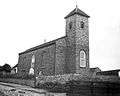 St Mary's Church, 1900-1912
 The village street, 1900-1912
 Ferry Boat Inn, 1900 - 1912
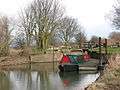 Narrowboat at Cottingwith Lock, near East Cottingwith
 View of the river near East Cottingwith, 1900 - 1912
References
- 1 2 "Key Figures for 2011 Census: Key Statistics: Area: Cottingwith CP (Parish)". Neighbourhood Statistics. Office for National Statistics. Retrieved 3 February 2013.
- ↑ "2001 Census: Key Statistics: Parish Headcounts: Area: Cottingwith CP (Parish)". Neighbourhood Statistics. Office for National Statistics. Retrieved 15 May 2008.
- ↑ Historic England. "Church of St Mary (1309872)". National Heritage List for England. Retrieved 19 October 2014.
- Gazetteer — A–Z of Towns Villages and Hamlets. East Riding of Yorkshire Council. 2006. p. 5.
External links
 Media related to East Cottingwith at Wikimedia Commons
- East Cottingwith in the Domesday Book
This article is issued from Wikipedia - version of the 10/10/2016. The text is available under the Creative Commons Attribution/Share Alike but additional terms may apply for the media files.