Eagle Ford Group
| Eagle Ford Group Stratigraphic range: Cenomanian to Turonian 96 to 90 million years[1] | |
|---|---|
| Type | Group |
| Sub-units | Britton Formation, Arcadia Park Shale Formation, Lake Waco Formation, South Bosque Formation, Boquillas Formation |
| Underlies | Austin Chalk |
| Overlies | Woodbine Formation or Buda Limestone |
| Lithology | |
| Primary | Shale |
| Other | Marl, limestone, sandstone, volcanic ash beds |
| Location | |
| Region | Texas |
| Country | United States |
| Type section | |
| Named for | Eagle Ford, Texas[2] |
| Named by | Robert T. Hill[2] |


The Eagle Ford Group (also called the Eagle Ford Shale) is a sedimentary rock formation deposited during the Cenomanian and Turonian ages of the Late Cretaceous over much of the modern-day state of Texas. The Eagle Ford is predominantly composed of organic matter-rich fossiliferous marine shales and marls with interbedded thin limestones. It derives its name from outcrops on the banks of the West Fork of the Trinity River near the old community of Eagle Ford,[2] which is now a neighborhood within the city of Dallas. The Eagle Ford outcrop belt trends from the Oklahoma/Texas border southward to San Antonio, westward to the Rio Grande, Big Bend National Park, and the Quitman Mountains of West Texas.[1] It also occurs in the subsurface of East Texas and South Texas, where it is the source rock for oil found in the Woodbine, Austin Chalk, and the Buda Limestone,[3] and is produced unconventionally in South Texas and the "Eaglebine" play of East Texas.[4] The Eagle Ford was one of the most actively drilled targets for unconventional oil and gas in the United States in 2010,[5] but its output had dropped sharply by 2015.[6] By the summer of 2016, Eagle Ford spending had dropped by two thirds from $30 million in 2014 to $10 million, according to an analysis from the research firm, Wood Mackenzie. This strike has been the hardest hit of any oil fields in the world. The spending is, however, expected to increase to $11.6 million in 2017. A full recovery is not expected any time soon.[7]
Fossils are relatively common in Eagle Ford rocks. Vertebrate fossils that have been found in the Eagle Ford include plesiosaurs, mosasaurs, teleost fish, and teeth from sharks and other fish.[8] Invertebrate fossils found in the Eagle Ford include crustaceans, sea urchins, swimming crinoids, ammonites, oysters, inoceramid clams, and other gastropod shells[9][10]
Depositional environment

The Eagle Ford was deposited in an inland sea (or epeiric sea) that covered much of modern-day Texas. The Texas shelf during the Cenomanian-Turonian was bounded by the Ouachita Uplift to the north, the Sabine Uplift to the east, relict reef margins of the Stuart City Formation and the Sligo Formation to the southeast, and the Western Interior Seaway to the west. The East Texas and South Texas regions were divided by an extension of the Llano Uplift known as the San Marcos Arch. Primary basins active during Eagle Ford deposition were the East Texas and Brazos Basins in East Texas and the Maverick Basin in South Texas.[11]
The bottom waters of the Eagle Ford sea were anoxic during most of Eagle Ford deposition, which is related to the global Oceanic Anoxic Event 2 (OAE2), or Cenomanian-Turonian boundary event, although the Texas shelf became anoxic nearly two million years prior to OAE2.[1] The low-oxygen conditions were conducive for preservation of the organic matter that ultimately generated the hydrocarbons associated with the Eagle Ford in the subsurface.[3] Evidence for anoxia include the high amounts of organic matter, lack of evidence for benthic organisms (fossils or trace fossils), and enrichment in the redox proxies molybdenum and vanadium.[1]
After the large drop in sea level (marine regression) associated with deposition of the Woodbine during the Early Cenomanian, sea-level began to rise (marine transgression), allowing for the deposition of Lower Eagle Ford organic-rich marls in South Texas and limestones of the Terrell Member of the Boquillas Formation in West Texas starting at about 96 million years ago. The rise in sea-level eventually drowned the East Texas Woodbine river deltas, initiating Eagle Ford deposition in East Texas.[12] The initial deposits, known as the Six Flags Limestone in Dallas and the Bluebonnet Limestone in Waco, are calcarenites predominantly composed of disaggregated prisms of Inoceramus clams and planktonic foraminifera tests.[13][14]
Following deposition of the calcarenites, a river delta began to prograde from the Ouachita Uplift to the northern East Texas Basin.[12] Although the sandstones and siltstones from this delta, known as the Templeton Member, were originally placed within the Woodbine Formation,[15] the ammonites found within them indicate that they are better associated with the Eagle Ford.[1] In areas unaffected by the Templeton Delta, depositional rates were low, producing a condensed section composed of organic-rich, calcareous marls, limestones, and volcanic ash beds in both South Texas and West Texas. The microfossils found within the marls are predominantly coccoliths and planktonic foraminifera, whereas the limestones contain abundant radiolaria and calcispheres (calcareous cysts produced by some dinoflagellates). Inoceramus fragments and fish bones are also found in these deposits.[1]
During the Late Cenomanian the Sabine Uplift along the modern-day Texas/Louisiana border became active, causing erosion of Eagle Ford and Woodbine sediments[16] and deposition within the Harris Delta complex.[17] Clay from this delta reached as far south as DeWitt County, Texas.[12]
Towards the end of the Late Cenomanian, the bottom waters of the Texas shelf and the Western Interior Seaway became oxygenated,[18] which may be related to the sea-level maximum associated with the Cenomanian-Turonian boundary event.[1] Evidence for this oxygenation event, known as the “Benthonic Zone,”[19] include an increase in the abundance of benthic organism fossils and bioturbation, a decrease in redox proxies uranium, molybdenum, and vanadium, and a reduction in organic matter.[20][21] This oxygenation event marks the boundary between the Lower and Upper Eagle Ford in West Texas and the subsurface of South Texas. In general, Upper Eagle Ford rocks deposited during the Cenomanian-Turonian boundary event (OAE2) contain much less organic matter than Lower Eagle Ford rocks, which is the reverse of organic matter trends seen in the global ocean.[10][18][20] An unconformity occurs throughout East Texas at this level, possibly due to a lack of sediments reaching the basin during the sea-level maximum.[12]
Sea-level began to drop after the Early Turonian sea-level maximum. This is most obvious at outcrops near Langtry, Texas, where water depths became shallower than 100 ft (30 m). This limestone-rich unit is known as the Langtry Member of the Boquillas Formation. It contains very little organic matter, and abundant sea urchin fossils.[10] The Kamp Ranch Limestone is found above the unconformity in the Dallas area. It is similar to the older Six Flags and Bluebonnet Limestones, as it is predominantly composed of disaggregated prisms of Inoceramus clams[22] and has ripple marks indicative of shallow-water deposition.[23] As sea-level continued to fall during the Late Turonian, deltaic sediments originating from the Ouachita Uplift prograded into the northern East Texas region. These sandstones are known as the Sub-Clarksville Delta in the subsurface and the Bells Sandstone in outcrop.[24][25] In the South Texas subsurface, the age equivalent unit to the Langtry Member is more calcareous than the underlying Upper Eagle Ford rocks, making them difficult to distinguish from the limestones of the overlying Austin Chalk, although an unconformity is found between the Eagle Ford and the Austin Chalk in both South Texas and East Texas.[1]
Eagle Ford unconformity

In the Cretaceous after the Woodbine and Eagle Ford formations were deposited, the Sabine Uplift started to become elevated again due to its reactivation ~88mya. A decrease in the effective elastic plate thicknesses caused the basin to subside, as the uplift became increasingly elevated. As a result, an estimated 150m of uplift over the Sabine region caused the eastern parts of the Woodbine and Eagle Ford formations to have a subaerial exposure, which eventually resulted in their easterly erosion. Deposition of the Austin Chalk after this erosional occurrence caused a sealing of the well known East Texas petroleum reservoir, and creation of a middle Cretaceous unconformity. Currently the Sabine Uplift is in the subsurface, and the middle Cretaceous unconformity is not seen because it is buried below a massive wedge of clastic sediments from the Late Cretaceous to the present.
Eagle Ford Group undivided
North of Hill County, shale, sandstone, and limestone; shale, bituminous, selenitic, with calcareous concretions and large septaria; sandstone and sandy limestone in upper and middle parts, platy, burrowed, medium to dark gray; in lower part bentonitic; hard limestone bed marks base in Ellis and Johnson Counties; locally forms low cuesta; thickness 200–300 feet.
Oil and natural gas production


Petrohawk drilled the first well to unconventionally produce gas from the Eagle Ford in 2008, in LaSalle County, Texas. Oil companies quickly extended the productive area, which stretches from the Texas-Mexico border in Webb and Maverick counties and extends 400 miles toward East Texas. The play is 50 miles wide and an average of 250 feet thick at a depth between 4000 and 12,000 feet. The shale contains a high amount of carbonate which makes it brittle and easier to use hydraulic fracturing to produce the oil or gas.[26]
The oil reserves in the Eagle Ford Shale Play were estimated in 2011 at 3 billion barrels.[27] The US Energy Information Administration estimated that the Eagle Ford held 50.2 trillion cubic feet of unproved, technically recoverable gas. The average well was estimated to produce 2.36 billion cubic feet of gas.[28]
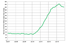
In the first six months of 2013, the Eagle Ford produced 2.69 billion cubic feet of gas and 599,000 barrels of oil and condensate per day; the oil production represented an increase of 51% over the average for 2012. By the end of 2013, production had skyrocketed to over 1,000,000 boe/day.[29] As of 2013, Eagle Ford production extended into 24 counties in Texas.[30] Analysts expect that $30 billion will be spent on further developing Eagle Ford in 2015. The large increase in tight oil production is one of the reasons behind the price drop in late 2014.[31]
The oil and gas operations are clearly visible on nighttime satellite photos of the United States, appearing as a diffuse bright patch about two hundred miles long, between the more concentrated lights of San Antonio, Corpus Christi, and neighboring cities.[32]
Proved reserves (US)
- US EIA, 2010: 2.5 trillion cubic feet of gas
- US EIA, 2011: 1.25 billion barrels of oil, 8.4 trillion cubic feet of gas[33]
- US EIA, 2012: 3.37 billion barrels of oil[34]
Mexico
The Eagle Ford Formation extends into northern Mexico's Burgos Basin where it is known as the Boquillas Formation, and has an average thickness of 200 meters. Total organic content (TOC) is estimated to average 5%. Technically recoverable hydrocarbons are estimated to be 343 trillion cubic feet of shale gas and 6.3 billion barrels of tight oil. The national oil company Pemex first began exploring in 2010-2011. Pemex has an exploration program in progress until 2015.[35]
In April 2013, Pemex started producing the nation's first shale gas well, just south of the US border. The well was completed in the equivalent of the Eagle Ford Formation.[36] Gas drilling in the Burgos Basin, close to the US border, has been hampered by drug gangs.[37] One Mexican industry expert said that Mexico was unlikely to develop the Eagle Ford, because of lack of pipeline infrastructure, lack of expertise, and because the Mexican company Pemex was investing in oil deposits that yield a higher rate of return.[38]
Hard times strike
With the worldwide decline in crude oil prices in 2015, a sharp downturn swept through Eagle Ford play. In January 2015, there were 840 active drilling rigs in Texas as a whole; by the end of the year, 321. Within the Eagle Ford play, the decline during this twelve-month period was from 200 to 76 rigs. The oil price decline rendered it uneconomical to drill sub-optimal wells. Particularly hard hit in the decline are the oil-field workers in South Texas.[6]
See also
References
- 1 2 3 4 5 6 7 8 Denne, R. A., Breyer, J. A., Callender, A. D., Hinote, R. E., Kariminia, M., Kosanke, T. H., Kita, Z., Lees, J. A., Rowe, H., Spaw, J. M., and Tur, N. (2016). Biostratigraphic and geochemical constraints on the stratigraphy and depositional environments of the Eagle Ford and Woodbine Groups of Texas: in Breyer, J. A. (ed.), The Eagle Ford Shale: A renaissance in U.S. oil production, AAPG Memoir 110, p. 1-86.
- 1 2 3 Hill, R. T. (1887) The topography and geology of the Crosstimbers and surrounding regions in North Texas: American Journal of Science, v. 33, no. 196, p. 291–303.
- 1 2 Surles, M. A. (1987) Stratigraphy of the Eagle Ford Group (Upper Cretaceous) and its source-rock potential in the East Texas Basin: Baylor Geological Studies Bulletin 45, Waco, Texas, 57 p.
- ↑ Hentz, T. F., Ambrose, W. A., and Smith, D. C. (2014). Eaglebine play of the southwestern East Texas basin: Stratigraphic and depositional framework of the Upper Cretaceous (Cenomanian-Turonian) Woodbine and Eagle Ford Groups: AAPG Bulletin, v. 98, p. 2551-2580.
- ↑ "Eagle Ford Shale - South Texas - Natural Gas & Oil Field" OilShaleGas.com
- 1 2 Jennifer Hiller, "Hard Times Hit Eagle Ford", San Antonio Express-News, January 3, 2016, pp. 1, A20
- ↑ Jennifer Hiller, "Spending in Eagle Ford has dropped by 67 percent", San Antonio Express-News, July 22, 2016, pp. 1, A6
- ↑ Jacobs, L.L., Polcyn, M.J., Winkler, D.A., Myers, T.S., Kennedy, J.G., and Wagner, J.B. (2013) Late Cretaceous strata and vertebrate fossils of North Texas, in Hunt, B.B., and Catlos, E.J., eds., Late Cretaceous to Quaternary Strata and Fossils of Texas: Field Excursions Celebrating 125 Years of GSA and Texas Geology, GSA South-Central Section Meeting, Austin, Texas, April 2013: Geological Society of America Field Guide 30, p. 1–13, doi:10.1130/2013.0030(01)
- ↑ Moreman, W. L. (1942) Paleontology of the Eagle Ford Group of north and central Texas: Journal of Paleontology, v. 16, p. 192–220.
- 1 2 3 Donovan, A. D., T. S. Staerker, A. Pramudito, W. Li, M. J. Corbett, C. M. Lowery, A. M. Romero, and R. D. Gardner (2012) The Eagle Ford outcrops of West Texas: Understanding heterogeneities within unconventional mudstone reservoirs: GCAGS Journal, v. 1, p. 162–185.
- ↑ Hentz, T. F., and S. C. Ruppel (2010) Regional lithostratigraphy of the Eagle Ford Shale: Maverick Basin to East Texas Basin: Transactions of the Gulf Coast Association of Geological Societies, v. 60, p. 225–337.
- 1 2 3 4 Denne, R. A., and Breyer, J. A. (2016) Regional depositional episodes of the Cenomanian-Turonian Eagle Ford and Woodbine groups of Texas: in Breyer, J. A. (ed.), The Eagle Ford Shale: A renaissance in U.S. oil production, AAPG Memoir 110, p. 87-135.
- ↑ Norton, G. H. (1965) Surface geology of Dallas County, in The geology of Dallas County: Dallas Geological Society, Dallas, Texas, p. 40–125.
- ↑ Silver, B. A. (1963) The Bluebonnet Member, Lake Waco Formation (Upper Cretaceous), Central Texas-A lagoonal deposit: Baylor Geologic Studies Bulletin 4, Waco, Texas, 46 p.
- ↑ Bergquist, H. R. (1949) Geology of the Woodbine Formation of Cooke, Grayson, and Fannin Counties, Texas: USGS, Oil and Gas Investigation, Preliminary Map 98.
- ↑ Halbouty, M. T., and J. J. Halbouty (1982) Relationships between East Texas field region and Sabine uplift in Texas: AAPG Bulletin, v. 66, p. 1042–1054.
- ↑ Turner, J. R., and S. J. Conger (1981) Environment of deposition and reservoir properties of the Woodbine Sandstone at Kurten field, Brazos County, Texas: Transactions of the Gulf Coast Association of Geological Societies, v. 31, p. 215–249.
- 1 2 Eldrett, J. S., D. Minisini, and S. C. Bergman (2014) Decoupling of the carbon cycle during Ocean Anoxic Event 2: Geology, v. 42, p. 567–570.
- ↑ Eicher, D. L., and P. Worstell (1970) Cenomanian and Turonian foraminifera from the Great Plains, United States: Micropaleontology, v. 16, p. 269–324.
- 1 2 Denne, R. A., R. E. Hinote, J. A. Breyer, T. H. Kosanke, J. A. Lees, N. Engelhardt-Moore, J. M. Spaw, and N. Tur (2014) The Cenomanian-Turonian Eagle Ford Group of South Texas: insights on timing and paleoceanographic conditions from geochemistry and micropaleontologic analyses: Palaeogeography, Palaeoclimatology, Palaeoecology, v. 413, p. 2-28.
- ↑ Boling, K. S. and Dworkin S. I. (2015) Origin of organic matter in the Eagle Ford Formation: Interpretation, v. 3, p. SH27–SH39.
- ↑ Reid, W. T. (1952) Clastic limestone in the Upper Eagle Ford Shale, Dallas County, Texas: Field and Laboratory, v. 20, p. 111–122.
- ↑ Hensleigh, D. E. (1983) Depositional setting of the Turonian Kamp Ranch Member, Eagle Ford Group, Northeast Texas: M.S. Thesis, University of Texas, Arlington, Texas, 358 p.
- ↑ McNulty, C. L, Jr. (1954) Fish Bed conglomerate and Sub-Clarksville sand, Grayson and Fannin Counties, Texas: AAPG Bulletin, v. 38, p. 335–337.
- ↑ McNulty, C. L. Jr. (1966) Nomenclature of uppermost Eagle Ford Formation in northeastern Texas: AAPG Bulletin, v. 50, p. 375–379.
- ↑ "Eagle Ford Information" Railroad Commission of Texas
- ↑ Selam Gebrekidan "Analysis: 100 years after boom, shale makes Texas oil hot again", Reuters. May 3, 2011.
- ↑ US Energy Information Administration, Annual Energy outlook 2012, accessed 14 Sept. 2013.
- ↑ Fuel Fix, Dec 3, 2013.
- ↑ Texas Railroad Commission, Eagle Ford Information, 24 July 2013.
- ↑ Ovale, Peder. "Her ser du hvorfor oljeprisen faller" In English Teknisk Ukeblad, 11 December 2014. Accessed: 11 December 2014.
- ↑ Melissa Block (April 10, 2014). "Drilling Frenzy Fuels Sudden Growth In Small Texas Town". NPR.
- ↑ US EIA, U.S. crude oil and nayural gas proved reserves, 1 Aug. 2013.
- ↑ US EIA, Table 2: Proved reserves of tight oil plays, 2014.
- ↑ "Technically Recoverable Shale Oil and Shale Gas Resources: An Assessment of 137 Shale Formations in 41 Countries Outside the United States" (PDF). U.S. Energy Information Administration (EIA). June 2013. Retrieved June 11, 2013.
- ↑ David Alire Garcia, "Mexico still far from tapping shale potential, minister says", Toronto Globe and Mail, 8 May 2013.
- ↑ Dudley Althaus, "Zetas gang poses daunting threat to Mexico's shale gas", Houston Chronicle, 26 Sept. 2012.
- ↑ Emily Pickrell, "Mexico unlikely to tap its Eagle Ford Shale, experts say", Houston Chronicle, 31 Oct. 2013.
External links
- The University of Texas at Dallas - Geosciences Department
- Energy Industry Photos
- Eagle Ford Shale News - Oil & Gas Journal
- U.S. Crude Oil Production Forecast- Analysis of Crude Types (PDF), Washington, DC: U.S. Energy Information Administration, 29 May 2014, pp. 8–9