Eagle's Nest Tunnel
| Eagle's Nest Tunnel | |||||||||||||
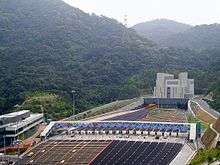 Toll plaza and north portal of Eagle's Nest Tunnel | |||||||||||||
| Chinese | 尖山隧道 | ||||||||||||
|---|---|---|---|---|---|---|---|---|---|---|---|---|---|
| |||||||||||||
Eagle's Nest Tunnel is a road tunnel in the New Territories of Hong Kong.
Officially opened on 21 March 2008, it connects Cheung Sha Wan and Sha Tin Valley through Eagle's Nest hill in Hong Kong in anticipation of future traffic demands generated by development in the northeast New Territories. It links south to Stonecutters Bridge and Nam Wan Tunnel, and north to Sha Tin Heights Tunnel to form a series of highways. The tunnel is part of Route 8. Together with Sha Tin Heights Tunnel, a toll of HK$8 (private cars) is charged.
Construction
The contract for the construction of the Eagle's Nest Tunnel was awarded to a joint venture between Leighton Contractors (Asia) Limited and Kumagai Gumi Company Ltd. Construction began in October 2003 and the estimated cost of the project is HK$1.84 billion.
The project comprises two 2.1 km, three-lane tunnels from Butterfly Valley to Sha Tin Valley through Eagle's Nest mountain (granite), and all the associated electrical, mechanical and landscaping works that will be necessary. The project was scheduled for completion in April 2007. The full scope of the construction project includes:
- Twin 2.1 km, three-lane tunnels
- 400m ventilation shaft
- North and south tunnel portal buildings
- Ventilation building off Tai Po Road
- Three-storey administration building
- Toll plaza and toll collection facilities (in addition to a footbridge, subway and canopy at the toll plaza)
- 500m tunnel approach road
- Miscellaneous earthworks, road works and landscaping
- Electrical and mechanical (E&M) for both the Eagle's Nest Tunnel and the adjacent, separately constructed, Sha Tin Heights Tunnel
Sandvik Tamrock Corp supplied five new Tamrock Axera tunnelling jumbos for the Eagle's Nest tunnelling project. The first unit is a Tamrock Axera T08, a two-boom jumbo with basket boom and Tamrock Computer Aided Drilling (TCAD) instrumentation. This unit is used at the ventilation shaft and was delivered in April 2004. The remaining four units are all Tamrock Axera T12DATA - three-boom fully computerised jumbos with basket booms. These units were delivered to the site in summer 2004 and are being used in the main tunnel with two units drilling side-by-side for the cross section area of height 11.8m and width 16.3m.
External links
| Wikimedia Commons has media related to Eagle's Nest Tunnel. |
- News.gov.hk
- (Chinese)
- Information in Highway department
| Preceded by Sha Tin Heights Tunnel |
Hong Kong Route 8 Eagle's Nest Tunnel |
Succeeded by Tsing Sha Highway |
Coordinates: 22°21′04″N 114°09′29″E / 22.3510°N 114.1580°E