Dynamite, Washington
The elevation of Dynamite is 2,333 feet. Dynamite appears on the Spangle WestU.S. Geological Survey Map. Spokane County is in the Pacific Time Zone (UTC -8 hours).
| Dynamite | |
|---|---|
| Unincorporated community | |
 Dynamite Location within the state of Washington | |
| Coordinates: 47°29′46″N 117°27′4″W / 47.49611°N 117.45111°WCoordinates: 47°29′46″N 117°27′4″W / 47.49611°N 117.45111°W | |
| Country | United States |
| State | Washington |
| County | Spokane |
| Elevation | 2,333 ft (711 m) |
| Time zone | Pacific (PST) (UTC-8) |
| • Summer (DST) | PDT (UTC-7) |
| GNIS feature ID | 1510923[1] |
Dynamite is a small unincorporated community in Spokane County, Washington, United States.
References
Municipalities and communities of Spokane County, Washington, United States | ||
|---|---|---|
| Cities | 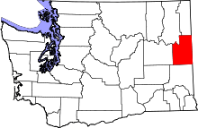 | |
| Towns | ||
| CDPs | ||
| Unincorporated communities | ||
| Ghost towns | ||
This article is issued from Wikipedia - version of the 3/31/2016. The text is available under the Creative Commons Attribution/Share Alike but additional terms may apply for the media files.