Dutsin-Ma
| Dutsin-Ma maa ma | |
|---|---|
| LGA and town | |
| Nickname(s): dutse shema. | |
 Dutsin-Ma Location in Nigeria | |
| Coordinates: 12°27′18″N 7°29′29″E / 12.45500°N 7.49139°ECoordinates: 12°27′18″N 7°29′29″E / 12.45500°N 7.49139°E | |
| Country |
|
| State | Katsina State |
| Established | 1976 |
| Government | |
| • Chairman | Alhaji lawal bature |
| Area | |
| • Total | 527 km2 (203 sq mi) |
| Elevation | 605 m (1,985 ft) |
| Population (2006 census) | |
| • Total | 169,671 |
| Time zone | WAT (UTC+1) |
| 3-digit postal code prefix | 821 |
| ISO 3166 code | NG.KT.DT |
Dutsin-Ma is a Local Government Area (LGA) in Katsina State, Nigeria. Its headquarters are in the town of Dutsin Ma. The Zobe Dam lies to the south of the town of Dutsin Ma.[1]
The LGA has an area of 527 km² and a population of 169,671 at the 2006 census. The postal code of the area is 821.[2]
History
Dutsin-ma became a Local Government in 1976.The chairman is the official Head of Local government. The inhabitants of the Local Government are predominantly Hausa and Fulani by tribe. Their main occupation is farming and Animal rearing.[3]
Furthermore, On vehicle license plates, Dutsin-Ma is abbreviated as DTM.[4]
References
- ↑ Isah Idris (2009-11-25). "Combating water scarcity in Katsina". Retrieved 2010-05-20.
- ↑ "Post Offices- with map of LGA". NIPOST. Retrieved 2009-10-20.
- ↑ "Katsina State- with History of Dustin-ma". Dustin-Ma LGA. Retrieved 2013-01-06.
- ↑ "NGR - Nigeria - Where's That Vehicle Come From?". Retrieved 2013-01-06.
State capital: Katsina | ||
| LGAs | 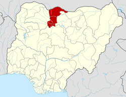 | |
Dutsin-Ma now host the first federal university in the state
This article is issued from Wikipedia - version of the 10/18/2014. The text is available under the Creative Commons Attribution/Share Alike but additional terms may apply for the media files.