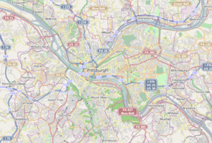
Duquesne Incline
 | |
| Locale | Pittsburgh, Pennsylvania |
|---|---|
| Dates of operation | May 17, 1877[1]–present |
| Track gauge | 5 ft (1,524 mm) |
| Length | 800 feet (244 m) |
| Headquarters | Pittsburgh, Pennsylvania |
| Website | |
|
Duquesne Incline | |
   | |
| Location | 1220 Grandview Ave., Pittsburgh, Pennsylvania |
| Coordinates | 40°26′21″N 80°1′5″W / 40.43917°N 80.01806°WCoordinates: 40°26′21″N 80°1′5″W / 40.43917°N 80.01806°W |
| Built | 1877 |
| Architectural style | Second Empire, Other, T pattern |
| NRHP Reference # | 75001609[2] |
| Added to NRHP | March 4, 1975 |
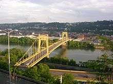
The Duquesne Incline (/duːˈkeɪn/) is an inclined plane railroad located near Pittsburgh's South Side neighborhood and scaling Mt. Washington. Designed by Samuel Diescher, the incline was completed in 1877 and is 800 feet (244 m) long, 400 feet (122 m) in height, and is inclined at a 30-degree angle. It is an unusual track gauge of 5 ft (1,524 mm).[3]
History
Originally steam powered, the Duquesne Incline was built to carry cargo up and down Mt. Washington in the late 19th century. It later carried passengers, particularly Mt. Washington residents who were tired of walking up footpaths to the top. Inclines were then being built all over Mt. Washington. But as more roads were built on “Coal Hill” most of the other inclines were closed. By the end of the 1960s, only the Monongahela Incline and the Duquesne Incline remained.
In 1962, the incline was closed, apparently for good. Major repairs were needed, and with so few patrons, the incline's private owners did little. But local Duquesne Heights residents launched a fund-raiser to help the incline. It was a huge success, and on July 1, 1963, the incline reopened under the auspices of a non-profit organization dedicated to its preservation.
The incline has since been totally refurbished. The cars, built by the J. G. Brill and Company of Philadelphia, have been stripped of paint to reveal the original wood. An observation deck was added at the top affording a view of Pittsburgh's "Golden Triangle", and the Duquesne Incline is now one of the city's most popular tourist attractions.
In popular culture
- The incline is featured in the opening scene of the The Next Three Days trailer. The same scene is featured about halfway through the film.
- It is also featured in the 1983 film Flashdance.
- In the 1987 movie, "Lady Beware", the characters played by Diane Lane and Cotter Smith ride the incline.
- The Duquesne Incline is a featured Pittsburgh landmark on Yinztagram.[4]
Gallery
 Lower building
 The view upwards when ascending the incline
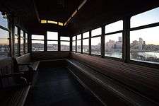 Interior view looking towards the Pittsburgh skyline
 Lobby of the lower station
 Platform of the lower station
See also
References
- ↑ "Conquering New Territory". Pittsburgh Commercial Gazette. May 18, 1877. p. 4.
The plane was opened yesterday to the public....
- ↑ National Park Service (2010-07-09). "National Register Information System". National Register of Historic Places. National Park Service.
- ↑ "Monongahela and Duquesne Inclines" (PDF). Retrieved 2009-05-21.
- ↑ "Yinztagram By Pegula". iTunes Store. Apple Inc. 2012. Archived from the original on December 15, 2012. Retrieved December 13, 2012.
External links
| Wikimedia Commons has media related to Duquesne Incline. |
- Port Authority of Allegheny County: The Inclines
- The Duquesne Incline, official web site
- Travel Channel video of Incline
- View on Google Maps
| Light rail (List of stations) | ||
|---|---|---|
| Inclines (Historical list) | ||
| Buses and busways (List of routes) | ||
| Former lines | ||
| Other | ||
| Topics |   | |
|---|---|---|
| Lists by county |
| |
| Lists by city | ||
| Other lists | ||
| ||