Dungeness Spit
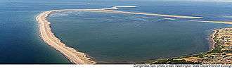

Dungeness Spit is a 5.5-mile (8.9 km) long sand spit jutting out from the northern edge of the Olympic Peninsula in northeastern Clallam County, Washington, USA, into the Strait of Juan de Fuca. It is the longest natural sand spit in the United States.[1][2] The body of water it encloses is called Dungeness Bay.[3] The Dungeness Spit is entirely within the Dungeness National Wildlife Refuge and home of the New Dungeness Lighthouse. Its land area, according to the United States Census Bureau, is 1,271,454 square meters (0.4909 sq mi, or 314.18 acres). The lighthouse once was run by United States Coast Guard, but in 1976 the agency installed an automatic light. Since 1994 the lighthouse has been staffed and maintained by the volunteer "New Dungeness Light Station Association".[4] The spit is open to the public year around.
The spit was first recorded by Europeans during the Spanish 1790 Quimper expedition. British explorer George Vancouver named the landform in 1792, writing "The low sandy point of land, which from its great resemblance to Dungeness in the British Channel, I called New Dungeness."[5] He named it after the Dungeness headland in England.
In December 2001 a heavy winter storm forced water over the spit. The next morning the spit was split in three places, and vehicles supplying the lighthouse were not able to traverse the spit for about a month.


See also
References
- ↑ "Dungeness Spit". Olympic National Park Sights. Fodor's Travel, Random House LLc. 2015. Retrieved March 15, 2015. External link in
|publisher=(help) - ↑ Adkison, Ron (2003). Washington: A Guide to Washington's Greatest Hiking Adventures. Globe Pequot. p. 32. ISBN 0762726075.
- ↑ U.S. Geological Survey Geographic Names Information System: Dungeness Bay
- ↑ "New Dungeness Lighthouse - History Part #4". newdungenesslighthouse.com. Retrieved 2014-07-31.
- ↑ Phillips, James W. (1971). Washington State Place Names. University of Washington Press. ISBN 0-295-95158-3.
External links
- Dungeness Spit: Block 2000, Census Tract 9816, Clallam County, Washington United States Census Bureau
- US Fish & Wildlife - Dungeness NWR
- New Dungeness Lighthouse
Coordinates: 48°10′07″N 123°08′22″W / 48.168604°N 123.1394°W