Dunbarton, New Hampshire
| Dunbarton, New Hampshire | |
|---|---|
| Town | |
|
First Congregational Church | |
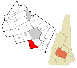 Location in Merrimack County and the state of New Hampshire | |
| Coordinates: 43°06′09″N 71°36′59″W / 43.10250°N 71.61639°WCoordinates: 43°06′09″N 71°36′59″W / 43.10250°N 71.61639°W | |
| Country | United States |
| State | New Hampshire |
| County | Merrimack |
| Incorporated | 1765 |
| Government | |
| • Board of Selectmen |
Brian Pike, Chair Thomas Groleau Robert "Bob" Martel |
| • Town Administrator | Line Comeau |
| Area | |
| • Total | 31.4 sq mi (81.2 km2) |
| • Land | 30.9 sq mi (80.0 km2) |
| • Water | 0.5 sq mi (1.2 km2) 1.50% |
| Elevation | 825 ft (251 m) |
| Population (2010) | |
| • Total | 2,758 |
| • Density | 88/sq mi (34/km2) |
| Time zone | Eastern (UTC-5) |
| • Summer (DST) | Eastern (UTC-4) |
| ZIP code | 03046 |
| Area code(s) | 603 |
| FIPS code | 33-19460 |
| GNIS feature ID | 0873583 |
| Website |
www |

Dunbarton is a town in Merrimack County, New Hampshire, United States. The population was 2,758 at the 2010 census.[1]
History
Originally granted as Gorham's-town in 1735, and re-granted as Starkstown in 1748, the town was incorporated in 1765 as Dunbarton. The name came from Dunbartonshire in Scotland, hometown to Archibald Stark, a prominent settler.[2]
Geography
According to the United States Census Bureau, the town has a total area of 31.4 square miles (81 km2), of which 30.9 sq mi (80 km2) is land and 0.5 sq mi (1.3 km2) is water, comprising 1.50% of the town. The highest point in Dunbarton is 925 feet (282 m) above sea level near NH Route 13 north of Dunbarton Center. Dunbarton lies fully within the Merrimack River watershed.[3]
The town claims to be the location of the geographic center of New England, based on a Boston University calculation from 2008.[4]
Demographics
| Historical population | |||
|---|---|---|---|
| Census | Pop. | %± | |
| 1790 | 917 | — | |
| 1800 | 1,222 | 33.3% | |
| 1810 | 1,256 | 2.8% | |
| 1820 | 1,450 | 15.4% | |
| 1830 | 1,067 | −26.4% | |
| 1840 | 950 | −11.0% | |
| 1850 | 915 | −3.7% | |
| 1860 | 901 | −1.5% | |
| 1870 | 778 | −13.7% | |
| 1880 | 708 | −9.0% | |
| 1890 | 524 | −26.0% | |
| 1900 | 551 | 5.2% | |
| 1910 | 513 | −6.9% | |
| 1920 | 405 | −21.1% | |
| 1930 | 572 | 41.2% | |
| 1940 | 495 | −13.5% | |
| 1950 | 533 | 7.7% | |
| 1960 | 632 | 18.6% | |
| 1970 | 825 | 30.5% | |
| 1980 | 1,174 | 42.3% | |
| 1990 | 1,759 | 49.8% | |
| 2000 | 2,226 | 26.5% | |
| 2010 | 2,758 | 23.9% | |
| Est. 2015 | 2,792 | [5] | 1.2% |
As of the census[7] of 2000, there were 2,226 people, 814 households, and 648 families residing in the town. The population density was 72.1 people per square mile (27.8/km²). There were 858 housing units at an average density of 27.8 per square mile (10.7/km²). The racial makeup of the town was 98.43% White, 0.09% African American, 0.45% Native American, 0.45% Asian, 0.04% from other races, and 0.54% from two or more races. Hispanic or Latino of any race were 0.31% of the population.
There were 814 households out of which 39.6% had children under the age of 18 living with them, 73.8% were married couples living together, 3.6% had a female householder with no husband present, and 20.3% were non-families. 14.1% of all households were made up of individuals and 3.2% had someone living alone who was 65 years of age or older. The average household size was 2.73 and the average family size was 3.03.
In the town the population was spread out with 27.5% under the age of 18, 4.0% from 18 to 24, 34.8% from 25 to 44, 26.6% from 45 to 64, and 7.1% who were 65 years of age or older. The median age was 38 years. For every 100 females there were 102.4 males. For every 100 females age 18 and over, there were 102.6 males.
The median income for a household in the town was $65,081, and the median income for a family was $67,448. Males had a median income of $46,042 versus $31,641 for females. The per capita income for the town was $27,892. About 2.3% of families and 2.8% of the population were below the poverty line, including 2.4% of those under age 18 and 4.9% of those age 65 or over.
Notable people
- Robert Lowell, poet; buried in Stark Cemetery
- John Ordway, sergeant in the Corps of Discovery, helped lead the Lewis and Clark Expedition
- Robert Rogers, commander of Rogers' Rangers during the French and Indian War
- Revolutionary War general John Stark and his wife Molly Stark once lived in Dunbarton. Their son Caleb Stark was born there.
References
- ↑ United States Census Bureau, American FactFinder, 2010 Census figures. Retrieved March 23, 2011.
- ↑ Gannett, Henry (1905). The Origin of Certain Place Names in the United States. Govt. Print. Off. p. 110.
- ↑ Foster, Debra H.; Batorfalvy, Tatianna N.; Medalie, Laura (1995). Water Use in New Hampshire: An Activities Guide for Teachers. U.S. Department of the Interior and U.S. Geological Survey.
- ↑ "Lots of Heart but Only One Center". Town of Dunbarton official website. Retrieved November 17, 2015.
- ↑ "Annual Estimates of the Resident Population for Incorporated Places: April 1, 2010 to July 1, 2015". Retrieved July 2, 2016.
- ↑ "Census of Population and Housing". Census.gov. Retrieved June 4, 2016.
- ↑ "American FactFinder". United States Census Bureau. Retrieved 2008-01-31.
External links
- Town of Dunbarton official website
- New Hampshire Economic and Labor Market Information Bureau Profile
Municipalities and communities of Merrimack County, New Hampshire, United States | ||
|---|---|---|
| Cities | 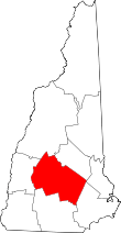 | |
| Towns | ||
| CDPs | ||
| Other unincorporated communities | ||
| Footnotes | ‡This populated place also has portions in an adjacent county or counties | |