Duirinish, Skye

Duirinish (Scottish Gaelic: Diùirinis) is a peninsula on the island of Skye in Scotland. It is situated in the north west between Loch Dunvegan and Loch Bracadale.
Skye's shape defies description and W. H. Murray wrote that "Skye is sixty miles long, but what might be its breadth is beyond the ingenuity of man to state".[1] Malcolm Slesser suggested that its shape "sticks out of the west coast of northern Scotland like a lobster's claw ready to snap at the fish bone of Harris and Lewis",[2] which would make Duirinish one of the claws.
The main peaks are Healabhal Mhòr and Healabhal Bheag, which reach 469 metres (1,539 ft) 488 metres (1,601 ft) respectively and are better known as MacLeod's Tables. They lie in the centre of the peninsula and their distinctive shapes are visible throughout much of north west Skye. Dunvegan Head marks the north end of the peninsula and Idrigill Point the south.[3]
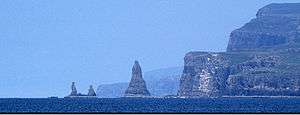
The west coast is now uninhabited and offshore there are only a few small islets: An Dubh Sgeir, An Stac and Macleod's Maidens. The latter are three stacks that resemble statues and were named after the drowning of a MacLeod chieftain's wife and two daughters.[4]
There are a number of small settlements principally along the west coast of Loch Dunvegan, including Borreraig (home of the piping MacCrimmons), Colbost with its Three Chimneys restaurant, Skinidin, Galtrigill and Totaig. Lephin and Glendale are further west. The latter is a substantial community-owned estate, and its "martyrs" played an important part in the Highland Clearances. The settlement of Lorgill on the west coast was cleared on 4 August 1830. Every crofter under the age of seventy was removed on threat of imprisonment, with those over that age being sent to the poorhouse.[5] Orbost and Roag are further south on the shore of Loch Bracadale. Crofting remains a mainstay of the economy.
The village of Dunvegan itself is the main settlement of the area and is located on the east shore of the loch just outside Duirinish. Nearby is Dunvegan Castle, which has been the seat of Clan MacLeod since 1200.[5]
Historically, Duirinish was also a parish in the county of Inverness-shire. The parish was larger than the peninsula and included Vaternish and Edinbane.[6]
The Gaelic name Diùranais or Diùirinis means "deer headland" and is in part derived from the Old Norse dyr. The peninsula is also known as dùthaich nam mogan, meaning "land of the mogan shoes", and the inhabitants as moganaich.[7]
See also
Notes
- ↑ Murray (1966) p. 146.
- ↑ Slesser (1970) p. 19.
- ↑ "Duirinish Peninsula" Gazetteer for Scotland. Retrieved 27 November 2009.
- ↑ Haswell-Smith (2004) p. 177.
- 1 2 Haswell-Smith (2004) p. 176.
- ↑ "Map of Parishes in the County of Inverness" scotlandsfamily.com. Retrieved 30 December 2009.
- ↑ Iain Mac an Tàilleir. "Placenames" (PDF). Pàrlamaid na h-Alba. Retrieved 2007-07-23.
References
- Haswell-Smith, Hamish (2004). The Scottish Islands. Edinburgh: Canongate. ISBN 978-1-84195-454-7.
- Murray, W.H. (1966) The Hebrides. London; Heinemann.
- Slesser, Malcolm (1970) The Island of Skye. Edinburgh; Scottish Mountaineering Club.
Coordinates: 57°26′N 6°39′W / 57.44°N 6.65°W