Duchesne County, Utah
| Duchesne County, Utah | |
|---|---|
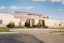 Duchesne County Courthouse in Duchesne | |
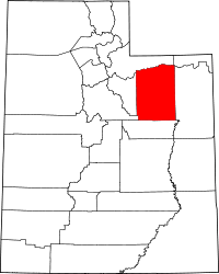 Location in the U.S. state of Utah | |
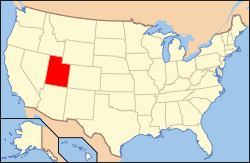 Utah's location in the U.S. | |
| Founded | 1915 |
| Named for | Duchesne River |
| Seat | Duchesne |
| Largest city | Roosevelt |
| Area | |
| • Total | 3,256 sq mi (8,433 km2) |
| • Land | 3,241 sq mi (8,394 km2) |
| • Water | 15 sq mi (39 km2), 0.5% |
| Population | |
| • (2010) | 18,607 |
| • Density | 5.7/sq mi (2/km²) |
| Congressional district | 1st |
| Time zone | Mountain: UTC-7/-6 |
| Website |
duchesne |
Duchesne County /duːˈʃeɪn/ is a county located in the U.S. state of Utah. As of the 2010 census, the population was 18,607.[1] Its county seat is Duchesne,[2] and the largest city is Roosevelt.
Etymology
Its name is of uncertain origin, there being seven origins given:
- The Ute Indian word doo-shane meaning dark canyon.
- Fort Duquesne, built by the French in what is now Pittsburgh, Pennsylvania.
- Rose du Chesne, founder of the Sacred Heart in St. Louis, MO.
- An early Indian chief in the region.
- An 1830s French fur trapper.
- Andre Duchesne, a French geographer and historian
- Prairie du Chien, Wisconsin, is about 200 miles northwest of Nauvoo, Illinois and sixty miles south of the Black River, which led to the LDS Church's 1840s lumber mills on the Mississippi river. (Robert Flanders, Nauvoo, page 289)
Geography
According to the U.S. Census Bureau, the county has a total area of 3,256 square miles (8,430 km2), of which 3,241 square miles (8,390 km2) is land and 15 square miles (39 km2) (0.5%) is water.[3] The northern part of the county contains part of the Uinta Mountains. The highest natural point in Utah, Kings Peak at 13,528 feet (4,123 m), is located in Duchesne County.
Adjacent counties
- Summit County (north)
- Daggett County (northeast)
- Uintah County (east)
- Carbon County (south)
- Utah County (southwest)
- Wasatch County (west)
National protected areas
- Ashley National Forest (part)
- Wasatch National Forest (part)
Demographics
| Historical population | |||
|---|---|---|---|
| Census | Pop. | %± | |
| 1920 | 9,093 | — | |
| 1930 | 8,263 | −9.1% | |
| 1940 | 8,958 | 8.4% | |
| 1950 | 8,134 | −9.2% | |
| 1960 | 7,179 | −11.7% | |
| 1970 | 7,299 | 1.7% | |
| 1980 | 12,565 | 72.1% | |
| 1990 | 12,645 | 0.6% | |
| 2000 | 14,371 | 13.6% | |
| 2010 | 18,607 | 29.5% | |
| Est. 2015 | 20,862 | [4] | 12.1% |
| U.S. Decennial Census[5] 1790–1960[6] 1900–1990[7] 1990–2000[8] 2010–2014[1] | |||
As of the census[9] of 2010, there were 18,607 people, 6,003 households, and 4,703 families residing in the county. The population density was 5.7 people per square mile (2/km²). There were 6,988 housing units at an average density of 2 per square mile (1/km²). The racial makeup of the county was 89.15% White, 0.24% Black or African American, 4.53% Native American, 0.28% Asian, 0.27% Pacific Islander, 2.64% from other races, and 2.89% from two or more races. 6.00% of the population were Hispanic or Latino of any race.[10]
There were 6,003 households out of which 40.23% had children under the age of 18 living with them, 64.72% were married couples living together, 8.65% had a female householder with no husband present, and 21.66% were non-families. 45.0% of all households had individuals under 18 and 22.6% had someone living alone who was 65 years of age or older. The average household size was 3.05 and the average family size was 3.47.
In the county, the population was spread out with 33.91% under the age of 18, 6.56% from 20 to 24, 25.38% from 25 to 44, 20.92% from 45 to 64, and 10.66% who were 65 years of age or older. The median age was 29.7 years. For every 100 females there were 102.80 males. For every 100 females age 18 and over, there were 100.00 males.
The median income for a household in the county was $31,298, and the median income for a family was $35,350. Males had a median income of $31,988 versus $19,692 for females. The per capita income for the county was $12,326. About 14.20% of families and 16.80% of the population were below the poverty line, including 19.60% of those under age 18 and 12.40% of those age 65 or over.
Government
- Clair Poulson, West Side Precinct Justice Court Judge
- Dave Boren, Sheriff
- JoAnn Evans, County Clerk-Auditor
Communities
Cities
Towns
Census-designated places
Unincorporated communities
- Altonah
- Arcadia, Redcap
- Bridgeland, Boneta
- Fruitland
- Hanna
- Mountain Home
- Strawberry
- Talmage
- Upalco
- Utahn
References
- 1 2 "State & County QuickFacts". United States Census Bureau. Retrieved December 29, 2013.
- ↑ "Find a County". National Association of Counties. Retrieved 2011-06-07.
- ↑ "2010 Census Gazetteer Files". United States Census Bureau. August 22, 2012. Retrieved March 27, 2015.
- ↑ "County Totals Dataset: Population, Population Change and Estimated Components of Population Change: April 1, 2010 to July 1, 2015". Retrieved July 2, 2016.
- ↑ "U.S. Decennial Census". United States Census Bureau. Retrieved March 27, 2015.
- ↑ "Historical Census Browser". University of Virginia Library. Retrieved March 27, 2015.
- ↑ Forstall, Richard L., ed. (March 27, 1995). "Population of Counties by Decennial Census: 1900 to 1990". United States Census Bureau. Retrieved March 27, 2015.
- ↑ "Census 2000 PHC-T-4. Ranking Tables for Counties: 1990 and 2000" (PDF). United States Census Bureau. April 2, 2001. Retrieved March 27, 2015.
- ↑ "American FactFinder". United States Census Bureau. Retrieved 2011-05-14.
- ↑ "2010 Census Interactive Population Search".
See also
- Ashley National Forest
- High Uintas Wilderness
- National Register of Historic Places listings in Duchesne County, Utah
 |
Summit County | Daggett County | | |
| Wasatch County | |
Uintah County | ||
| ||||
| | ||||
| Utah County | Carbon County |
Municipalities and communities of Duchesne County, Utah, United States | ||
|---|---|---|
| Cities | | |
| Towns | ||
| CDPs | ||
| Unincorporated communities | ||
| Indian reservation | ||
| Ghost town | ||
| Footnotes | ‡This populated place also has portions in an adjacent county or counties | |
Coordinates: 40°17′N 110°26′W / 40.28°N 110.44°W