Drygrange Old Bridge
| Drygrange Old Bridge | |
|---|---|
 | |
| Coordinates | 55°36′14″N 2°40′32″W / 55.603915°N 2.675603°WCoordinates: 55°36′14″N 2°40′32″W / 55.603915°N 2.675603°W |
| Crosses | River Tweed |
| Characteristics | |
| Material | Stone |
| Longest span | 105 feet (32 m) |
| Number of spans | 4 |
| History | |
| Construction begin | 1776 |
| Construction end | 1780 |
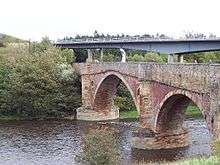
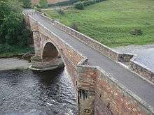
The Drygrange Old Bridge is a disused road bridge over the River Tweed near Melrose in the Scottish Borders.
History
It was built between 1776 and 1780 to a design by Scottish architect and engineer Alexander Stevens.[1][2] It replaced a ferry as part of an improvement to a turnpike road.[2]
It was listed as a Category A listed building in 1970.[1]
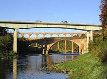
It carried the A68 over the Tweed until 1974 when it was replaced by a box girder bridge to the east, engineered by Sir Alexander Gibb & Partners.[1] The old bridge is not open to vehicles, but can be crossed by pedestrians and bicycles.
Design
The Old Bridge has a central span of 105 feet (32 m), with two side spans of 55 feet (17 m), and a smaller arch in the south abutment.[1][2] The central arch has a rise of 34 feet (10 m).[2] The rounded cutwaters are carried up to the level of the roadway and are topped with angular pedestrian refuges.[2]
Hollow spandrels reduce the weight of the structure, an innovation by Thomas Telford.[1][3] The bridge has been modified by raising the level of the roadway on the approaches to make it more level, but the level of the original roadway can be seen in the string course on the exterior of the bridge.[1]
It is near to the Roman settlement of Trimontium, which is to the south-west of the viaduct.[4] To the west of the bridge is the Leaderfoot Viaduct, a disused railway viaduct, and to the east of the Old Bridge is its modern successor.[4] This group of three bridges is sometimes known as Tripontium.[5]
References
- 1 2 3 4 5 6 "Drygrange Old Bridge (Ref: 15106)". historic-scotland.gov.uk. Retrieved 16 March 2015.
- 1 2 3 4 5 "Drygrange Old Bridge". rcahms.gov.uk. Retrieved 16 March 2015.
- ↑ "Ashford Carbonell Bridge". engineering-timelines.com. Retrieved 16 March 2015.
- 1 2 Google (16 March 2015). "Drygrange Old Bridge" (Map). Google Maps. Google. Retrieved 16 March 2015.
- ↑ "Leaderfoot Viaduct". rcahms.gov.uk. Retrieved 15 March 2015.
External links
| Wikimedia Commons has media related to Drygrange Old Bridge. |