Dromiskin
| Dromiskin Droim Ineasclainn | |
|---|---|
| Village | |
 Dromiskin Location in Ireland | |
| Coordinates: 53°55′20″N 6°23′56″W / 53.922259°N 6.398814°WCoordinates: 53°55′20″N 6°23′56″W / 53.922259°N 6.398814°W | |
| Country | Ireland |
| Province | Leinster |
| County | County Louth |
| Time zone | WET (UTC+0) |
| • Summer (DST) | IST (WEST) (UTC-1) |

Dromiskin (historically Druminisklin, from Irish: Druim/Droim Ineasclainn)[1] is a village and townland in County Louth, Ireland. It is situated 10 km south of Dundalk, about 1 km inland from the Irish Sea coast, and is located in one of Louth's most historical areas.
History
The village was home to a monastery for hundreds of years, once visited by Saint Patrick. The first bishop of Dromiskin was Lughaidh,[2] son of Aengus mac Nadfraoch the first Christian king of Munster. St. Patrick reputedly pierced Aengus's foot with his pastoral staff during the baptism.[3]
Áed Findliath monarch of Ireland, son of Niall Caille, retired to and died at Dromiskin. The Chronicon Scotorum records his death at 879. O'Donovan records his death as 876 and the Annals of Ulster place it at 878.
The next few hundred years would be turbulent times for Dromiskin. The constant plundering by both Viking and Irish would destroy the Abbey and disperse the monks. Annudh macRuaire rampaged through the territory in 1043[4] and Dromiskin was destroyed. The ecclesiastical site was abandoned and the monks took refuge in the neighbouring Abbey of St.Mochta's, the possessions of this ancient church being placed in the hands of the Prior of Louth Abbey.
Dromiskin served as the home to the Archbishops of Armagh for a time. The Archbishops of Armagh lived at Dromiskin House. Archbishop Milo Sweetman is buried here.
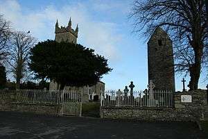
The old ninth century round tower and parts of the Abbey still remain. From the tower there is a view of all of Dundalk Bay and the surrounding countryside.
Parish
The village is part of the Darver and Dromiskin parish, Darver[5] being a neighbouring village. The parish is bounded by the Fane River on the north and by the Glyde River on the south.
Demographics
Since the mid-1990s, Dromiskin, like many areas in County Louth, has seen a marked increase in population. In 2006, 992 people were living in Dromiskin with 1,932 living in the electoral division.[6]
Sport
The local Gaelic Football club, St. Joseph's (formed in 1961), covering the entire parish of Darver & Dromiskin, won the Senior county championship (Joe Ward Cup) in 1996 and 2006. The club is now playing Intermediate level championship as well as Division 2 league football in 2011, having been relegated from League Division 1 in 2010. The club's Minor (U-18) team won the county championship for the first time in 2009 and retained the championship in 2010. There is also an athletics (track and field) club (St Peter's AC) based on the outskirts of the village.
Transport
Bus Éireann route 168, Annagassan to Dundalk serves Dromiskin Mondays to Fridays inclusive providing one journey in each direction. [7]
See also
References
- ↑ Placenames Database of Ireland (see archival records)
- ↑ O'Clery; Todd; Reeves. The martyrology of Donegal:. pp. 437–.
- ↑ Geoffrey Keating; John O'Mahony (1857). The History of Ireland:. pp. 407–.
- ↑ http://www.ucc.ie/celt/online/T100005B/text015.html
- ↑ Samuel Lewis (1837). A Topographical Dictionary of Ireland. Lewis. pp. 449–.
- ↑ Central Statistics Office, Census 2006 (Volume 1, Tables 5 and 6)
- ↑ http://www.buseireann.ie/pdf/1272289679-168.pdf
External links
Places in County Louth | ||
|---|---|---|
| Towns |  | |
| Villages and Townlands | ||
| ||